Lower Teakettle NEON (TEAK) Soil Descriptions
Distributed Soils Reports
Pedon Descriptions
Pit‐level observations and field measurements reported using the standard NRCS format. They contain volume estimates for coarse fragments > 20 mm where applicable.
Site Level Plot Summary
A narrative summary that places the sampled soil pedons in the broader context of soils and geomorphology for the entire NEON site.
Megapit Images
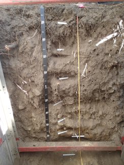
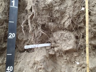
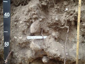
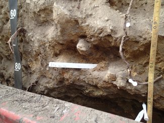
D17 TEAK megapit soil profile 0-200 cm
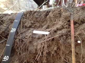
D17 TEAK megapit soil profile 0-30 cm
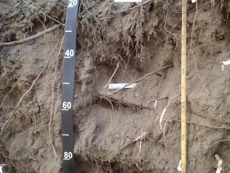
D17 TEAK megapit soil profile 20-70 cm
D17 TEAK megapit soil profile 65-105 cm
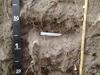
D17 TEAK megapit soil profile 97-133 cm
D17 TEAK megapit soil profile 128-165
D17 TEAK megapit soil profile 155-185 cm
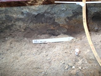
D17 TEAK megapit soil profile 185-200 cm
Megapit Pedon Description
| Print Date | Feb 22 2018 |
|---|---|
| Description Date | Aug 9 2016 |
| Describer | Phil Smith, Rafael Ortiz, Nelson Velazquez |
| Site ID | S2016CA019002 |
| Pedon ID | S2016CA019001 |
| Lab Source ID | KSSL |
| Lab Pedon # | 16N1950 |
| Soil Name as Described/Sampled | Deadman |
| Classification | Coarse-loamy, mixed, superactive, frigid Pachic Humixerepts |
| Pedon Type | undefined observation |
| Pedon Purpose | laboratory sampling site |
| Taxon Kind | family |
| Associated Soils | Sirretta |
| Physiographic Division | Pacific Mountain |
| Physiographic Province | Pacific Border Province |
| Physiographic Section | Sierra Nevada |
| Geomorphic Setting | on backslope of side slope of mountain on mountains |
| Upslope Shape | linear |
| Cross Slope Shape | convex |
| Particle Size Control Section | 25 to 100 cm. |
| Description origin | NASIS |
| State | California |
| County | Fresno |
| MLRA | 22A -- Sierra Nevada Mountains |
| Soil Survey Area | CA750 -- Sierra National Forest Area Parts of Fresno, California 2-SON -- Sonora, California |
| Map Unit | 161 -- Sirretta family and Umpa family, wet, 2 to 25 percent slopes |
| Quad Name | Nelson Mountain, California |
| Std Latitude | 37.0065278 |
| Std Longitude | -119.0056667 |
| Latitude | 37 degrees 0 minutes 23.50 seconds north |
| Longitude | 119 degrees 0 minutes 20.40 seconds west |
| Datum | WGS84 |
| Primary Earth Cover | Tree cover |
| Secondary Earth Cover | Conifers |
| Bedrock Kind | granite |
| Bedrock Depth | 205 centimeters |
| Bedrock Hardness | strongly cemented |
| Surface Fragments | 5.0 percent nonflat subrounded indurated granite fragments and 4.0 percent nonflat subangular indurated 2- to 5-millimeter |
| Description database | KSSL |
| Diagnostic Features | umbric epipedon 0 to 132 cm. redox depletions with chroma 2 or less 162 to 205 cm. redox concentrations 162 to 205 cm. |
| Top Depth (cm) | 174 |
| Bottom Depth (cm) | 205 |
| Restriction Kind | densic material |
| Restriction Hardness | very weakly cemented |
| Top Depth (cm) | 205 |
| Bottom Depth (cm) | 230 |
| Restriction Kind | bedrock, paralithic |
| Restriction Hardness | strongly cemented |
| Slope (%) | 22.0 |
| Elevation (meters) | 2,157.0 |
| Aspect (deg) | 190 |
| MAAT (C) | 7.2 |
| MAP (mm) | 70 |
| Frost-Free Days | 150 |
| Drainage Class | excessively |
| Slope Length (meters) | 152 |
| Horizon Details |
A1--0 to 19 centimeters (0.0 to 7.5 inches); dark grayish brown (2.5Y 4/2) sandy loam, black (2.5Y 2.5/1), moist; 75 percent sand; 6 percent clay; weak fine granular structure; soft, very friable, nonsticky, nonplastic; very few very fine roots throughout and few medium roots throughout and few fine roots throughout and very few coarse roots throughout; common fine dendritic tubular pores; 1 percent subangular indurated 20 to 76-millimeter granite fragments and 3 percent subangular indurated 2 to 5-millimeter granite fragments and 7 percent subangular indurated 5 to 20-millimeter granite fragments; noneffervescent; very strongly acid, pH 4.6, pH meter smooth boundary. A2--19 to 67 centimeters (7.5 to 26.4 inches); dark grayish brown (2.5Y 4/2) gravelly sandy loam, very dark gray (2.5Y 3/1), moist; 75 percent sand; 6 percent clay; structureless massive; soft, very friable, nonsticky, nonplastic; very few very fine roots throughout and common very coarse roots throughout and common medium roots throughout and very few fine roots throughout and very few coarse roots throughout; common very fine dendritic tubular and common fine dendritic tubular pores; 2 percent subangular indurated 20 to 76-millimeter granite fragments and 4 percent subangular indurated 2 to 5-millimeter granite fragments and 10 percent subangular indurated 5 to 20-millimeter granite fragments; noneffervescent; strongly acid, pH 5.5, pH meter wavy boundary. A3--67 to 101 centimeters (26.4 to 39.8 inches); dark grayish brown (2.5Y 4/2) gravelly sandy loam, very dark grayish brown (2.5Y 3/2), moist; 75 percent sand; 6 percent clay; structureless massive; soft, very friable, nonsticky, nonplastic; very few very fine roots throughout and few very coarse roots throughout and common medium roots throughout and very few fine roots throughout and common coarse roots throughout; common fine dendritic tubular pores; 3 percent subangular indurated 20 to 76-millimeter granite fragments and 8 percent subangular indurated 2 to 5-millimeter granite fragments and 10 percent subangular indurated 5 to 20-millimeter granite fragments; noneffervescent; moderately acid, pH 5.6, pH meter wavy boundary. 2AC--101 to 132 centimeters (39.8 to 52.0 inches); light olive brown (2.5Y 5/3) extremely gravelly loamy sand, very dark grayish brown (2.5Y 3/2), moist; 80 percent sand; 3 percent clay; structureless massive; soft, very friable, nonsticky, nonplastic; few very coarse roots throughout and common medium roots throughout and few coarse roots throughout; few very fine dendritic tubular pores; 1 percent subangular indurated 250 to 600-millimeter granite fragments and 10 percent subangular indurated 20 to 250-millimeter granite fragments and 10 percent subangular indurated 5 to 20-millimeter granite fragments and 15 percent subangular indurated 20 to 76-millimeter granite fragments and 30 percent subangular indurated 2 to 5-millimeter granite fragments; noneffervescent; strongly acid, pH 5.5, pH meter wavy boundary. 2C1--132 to 162 centimeters (52.0 to 63.8 inches); light yellowish brown (2.5Y 6/3) extremely gravelly sandy loam, olive brown (2.5Y 4/3), moist; 75 percent sand; 6 percent clay; structureless massive; soft, very friable, nonsticky, nonplastic; very few medium roots throughout and very few coarse roots throughout; common fine interstitial pores; 5 percent subangular indurated 76 to 250-millimeter granite fragments and 15 percent subangular indurated 20 to 76-millimeter granite fragments and 20 percent subangular indurated 5 to 20-millimeter granite fragments and 20 percent subangular indurated 2 to 5-millimeter granite fragments; noneffervescent; very strongly acid, pH 5.0, pH meter wavy boundary. 3C2--162 to 174 centimeters (63.8 to 68.5 inches); light yellowish brown (2.5Y 6/4) very gravelly sandy loam, olive brown (2.5Y 4/4), moist; 65 percent sand; 11 percent clay; structureless massive; slightly hard, friable, nonsticky, nonplastic; very few medium roots throughout and very few fine roots throughout; common fine interstitial pores; 3 percent fine irregular 5YR 4/6), moist, masses of oxidized iron and 15 percent medium irregular 2.5Y 5/2), moist, iron depletions; 5 percent subangular indurated 20 to 76-millimeter granite fragments and 20 percent subangular indurated 2 to 5-millimeter granite fragments and 25 percent subangular indurated 5 to 20-millimeter granite fragments; noneffervescent; very strongly acid, pH 4.7, pH meter wavy boundary. 3C3--174 to 185 centimeters (68.5 to 72.8 inches); light yellowish brown (2.5Y 6/3) very gravelly sandy loam, olive brown (2.5Y 4/3), moist; 65 percent sand; 11 percent clay; structureless massive; slightly hard, friable, nonsticky, nonplastic; brittle; very few medium roots throughout and very few fine roots throughout; common fine interstitial pores; 20 percent medium irregular 5YR 4/4), moist, masses of oxidized iron and 20 percent coarse irregular 2.5Y 5/2), moist, iron depletions; 10 percent subangular indurated 20 to 76-millimeter granite fragments and 12 percent subangular indurated 2 to 5-millimeter granite fragments and 20 percent subangular indurated 5 to 20-millimeter granite fragments; noneffervescent; strongly acid, pH 5.1, pH meter wavy boundary. 3C4--185 to 205 centimeters (72.8 to 80.7 inches); light brownish gray (2.5Y 6/2) very gravelly sandy loam, dark grayish brown (2.5Y 4/2), moist; 70 percent sand; 8 percent clay; structureless massive; slightly hard, friable, nonsticky, nonplastic; brittle; few very fine interstitial pores; 5 percent subangular indurated 20 to 76-millimeter granite fragments and 15 percent subangular indurated 5 to 20-millimeter granite fragments and 20 percent subangular indurated 2 to 5-millimeter granite fragments; noneffervescent; strongly acid, pH 5.4, pH meter; abrupt wavy boundary. R--205 to 225 centimeters (80.7 to 88.6 inches); strongly cemented granite bedrock; strongly cemented. |
Credits: This megapit soil pedon description was generously created by USDA Natural Resource Conservation Service staff, with particular thanks to Larry West, Jon Hempel, and numerous field staff.