North Sterling NEON (STER) Soil Descriptions
Distributed Soils Reports
Pedon Descriptions
Pit‐level observations and field measurements reported using the standard NRCS format. They contain volume estimates for coarse fragments > 20 mm where applicable.
Site Level Plot Summary
A narrative summary that places the sampled soil pedons in the broader context of soils and geomorphology for the entire NEON site.
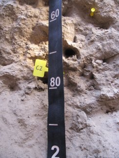
Megapit Images
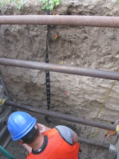
D10 STER megapit soil profile 0-200 cm
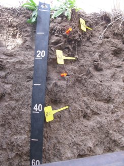
D10 STER megapit soil profile 0-58 cm
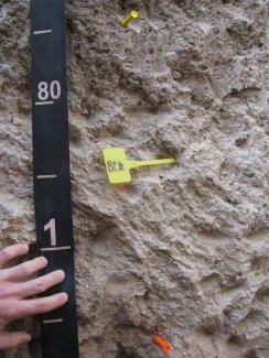
D10 STER megapit soil profile 65-115 cm
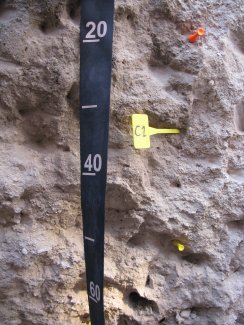
D10 STER megapit soil profile 115-165 cm
D10 STER megapit soil profile 155-199 cm
Megapit Pedon Description
| Print Date | Jul 22 2015 |
|---|---|
| Description Date | Apr 8 2013 |
| Describer | Andy Steinert |
| Site ID | S2013CO075001 |
| Site Note | Sterling NEON (National Ecological Observatory Network) pit |
| Pedon ID | S2013CO075001 |
| Lab Source ID | SSL |
| Lab Pedon # | 13N39573 |
| Soil Name as Described/Sampled | Goshen |
| Classification | Fine-silty, mixed, superactive, mesic Pachic Argiustolls |
| Pedon Type | correlates to named soil |
| Pedon Purpose | research site |
| Taxon Kind | series |
| Physiographic Division | Interior Plains |
| Physiographic Province | Great Plains Province |
| Physiographic Section | Colorado Piedmont |
| Geomorphic Setting | drainageway on upland |
| Upslope Shape | linear |
| Cross Slope Shape | concave |
| Particle Size Control Section | 28 to 78 cm. |
| Description origin | Pedon PC 5.1 |
| State | Colorado |
| County | Logan |
| MLRA | 72 -- Central High Tableland |
| Soil Survey Area | CO075 -- Logan County, Colorado 5-FTM -- Fort Morgan, Colorado |
| Map Unit | 126 -- Weld loam, 1 to 3 percent slopes |
| Quad Name | Buffalo Springs Ranch NE, Colorado |
| Std Latitude | 40.4598333 |
| Std Longitude | -103.0300833 |
| Latitude | 40 degrees 27 minutes 35.40 seconds north |
| Longitude | 103 degrees 1 minutes 48.30 seconds west |
| Datum | WGS84 |
| UTM Zone | 13 |
| UTM Easting | 667024 meters |
| UTM Northing | 4480661 meters |
| Primary Earth Cover | Crop cover |
| Secondary Earth Cover | Close-grown crop |
| Parent Material | local alluvium |
| Description database | KSSL |
| Diagnostic Features | mollic epipedon 0 to 70 cm. argillic horizon 28 to 121 cm. calcic horizon 70 to 121 cm. |
| Slope (%) | 2.0 |
| Elevation (meters) | 1,369.0 |
| Aspect (deg) | 0 |
| Drainage Class | well |
| Horizon Details |
Ap1--0 to 11 centimeters (0.0 to 4.3 inches); dark grayish brown (10YR 4/2) broken face clay loam, very dark gray (10YR 3/1) broken face, moist; 35 percent sand; 37 percent silt; 28 percent clay; weak fine granular, and weak fine subangular blocky structure; soft, very friable, moderately sticky, slightly plastic; common very fine roots throughout and common fine roots throughout; noneffervescent, by HCl, 1 normal; neutral, pH 6.8, pH meter; clear smooth boundary. Lab sample # 13N04681 Ap2--11 to 28 centimeters (4.3 to 11.0 inches); dark grayish brown (10YR 4/2) broken face clay loam, very dark gray (10YR 3/1) broken face, moist; 32 percent sand; 35 percent silt; 33 percent clay; strong medium angular blocky, and strong coarse angular blocky structure; very hard, firm, moderately sticky, moderately plastic; common very fine roots throughout and common fine roots throughout; 15 percent distinct pressure faces on all faces of peds; noneffervescent, by HCl, 1 normal; neutral, pH 6.7, pH meter; clear smooth boundary. Lab sample # 13N04682 Bt--28 to 70 centimeters (11.0 to 27.6 inches); grayish brown (10YR 5/2) broken face silty clay loam, very dark grayish brown (10YR 3/2) broken face, moist; 15 percent sand; 51 percent silt; 34 percent clay; strong coarse prismatic parts to strong medium angular blocky, and strong medium prismatic parts to strong medium angular blocky structure; very hard, firm, very sticky, moderately plastic; common very fine roots throughout; 20 percent prominent clay films on all faces of peds; noneffervescent, by HCl, 1 normal; neutral, pH 6.9, pH meter; clear wavy boundary. Lab sample # 13N04683 Btk--70 to 121 centimeters (27.6 to 47.6 inches); light gray (10YR 7/2) broken face silty clay loam, brown (10YR 5/3) broken face, moist; 15 percent sand; 55 percent silt; 30 percent clay; strong coarse prismatic parts to moderate medium angular blocky, and strong medium prismatic parts to moderate medium angular blocky structure; very hard, friable, moderately sticky, moderately plastic; common very fine roots throughout; 5 percent distinct clay films on all faces of peds; carbonate, finely disseminated throughout and 1 percent fine irregular carbonate masses on faces of peds and 2 percent medium irregular carbonate masses on faces of peds; 18.0 Percent CaCO3 (Exists in NASIS Horizon); strong effervescence, by HCl, 1 normal; moderately alkaline, pH 8.1, pH meter; clear wavy boundary. Lab sample # 13N04684 C1--121 to 159 centimeters (47.6 to 62.6 inches); pale brown (10YR 6/3) broken face sandy loam, brown (10YR 4/3) broken face, moist; 70 percent sand; 20 percent silt; 10 percent clay; massive; soft, very friable, slightly sticky, nonplastic; common very fine roots throughout; carbonate, finely disseminated throughout; 2 percent nonflat subrounded 2 to 5-millimeter calcareous conglomerate fragments; 11.0 Percent CaCO3 (Exists in NASIS Horizon); strong effervescence, by HCl, 1 normal; moderately alkaline, pH 8.2, pH meter; gradual wavy boundary. Lab sample # 13N04685 C2--159 to 213 centimeters (62.6 to 83.9 inches); very pale brown (10YR 7/3) broken face loamy sand, brown (10YR 5/3) broken face, moist; 86 percent sand; 10 percent silt; 4 percent clay; massive; soft, very friable, nonsticky, nonplastic; carbonate, finely disseminated throughout; 7 percent nonflat subrounded 2 to 75-millimeter calcareous conglomerate fragments; 17.0 Percent CaCO3 (Exists in NASIS Horizon); strong effervescence, by HCl, 1 normal; moderately alkaline, pH 8.4, pH meter. Lab sample # 13N04686 |
Credits: This megapit soil pedon description was generously created by USDA Natural Resource Conservation Service staff, with particular thanks to Larry West, Jon Hempel, and numerous field staff.