San Joaquin Experimental Range NEON (SJER) Soil Descriptions
Distributed Soils Reports
Pedon Descriptions
Pit‐level observations and field measurements reported using the standard NRCS format. They contain volume estimates for coarse fragments > 20 mm where applicable.
Site Level Plot Summary
A narrative summary that places the sampled soil pedons in the broader context of soils and geomorphology for the entire NEON site.
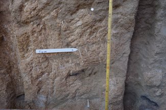
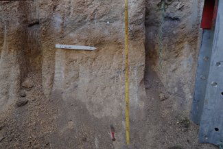
Megapit Images
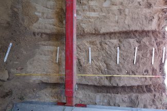
D17 SJER megapit soil profile 0-176 cm
D17 SJER megapit soil profile 0-36 cm
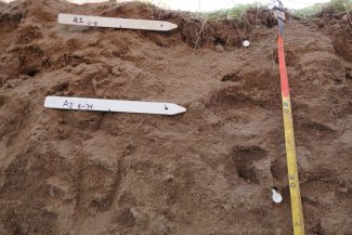
D17 SJER megapit soil profile 16-57 cm
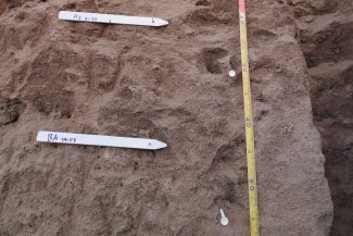
D17 SJER megapit soil profile 39-81 cm
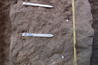
D17 SJER megapit soil profile 75-118 cm
D17 SJER megapit soil 117-175 cm
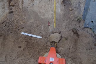
D17 SJER megapit soil profile 150-175 cm
Megapit Pedon Description
| Print Date | Feb 21 2018 |
|---|---|
| Description Date | Nov 15 2016 |
| Describer | Julie Baker |
| Site ID | S2016CA019003_MP |
| Pedon ID | S2016CA039001 |
| Lab Source ID | KSSL |
| Lab Pedon # | 17N0137 |
| Soil Name as Described/Sampled | SJER |
| Geomorphic Setting | on backslope of interfluve of hillslope on backslope of interfluve of hills |
| Upslope Shape | convex |
| Cross Slope Shape | convex |
| Particle Size Control Section | 25 to 100 cm. |
| Description origin | NASIS |
| State | California |
| County | Fresno |
| MLRA | 18 -- Sierra Nevada Foothills |
| Latitude | 37 degrees 6 minutes 25.56 seconds north |
| Longitude | 119 degrees 43 minutes 58.80 seconds west |
| Datum | WGS84 |
| UTM Zone | 11 |
| UTM Easting | 257145 meters |
| UTM Northing | 4110249 meters |
| Primary Earth Cover | Tree cover |
| Secondary Earth Cover | Intermixed conifers and hardwoods |
| Parent Material | sandy eolian deposits over alluvium |
| Bedrock Kind | granite |
| Bedrock Depth | 170 centimeters |
| Bedrock Hardness | strongly cemented |
| Bedrock Fracture Interval | 200 centimeters or more |
| Description database | KSSL |
| Diagnostic Features | mollic epipedon 0 to 57 cm. |
| Top Depth (cm) | 129 |
| Bottom Depth (cm) | 170 |
| Restriction Kind | bedrock, paralithic |
| Restriction Hardness | weakly cemented |
| Top Depth (cm) | 170 |
| Bottom Depth (cm) | 185 |
| Restriction Kind | bedrock, lithic |
| Restriction Hardness | strongly cemented |
| Slope (%) | 15.0 |
| Elevation (meters) | 374.0 |
| Aspect (deg) | 17 |
| Drainage Class | well |
| Horizon Details |
A1--0 to 8 centimeters (0.0 to 3.1 inches); dark brown (7.5YR 3/2) loamy sand, brown (10YR 5/3), dry; 82 percent sand; 3 percent clay; weak medium subangular blocky parts to moderate medium granular structure; soft, very friable, slightly sticky, nonplastic; common very fine roots throughout and common fine roots throughout; many very fine irregular and common fine tubular and common fine irregular pores; 7 percent nonflat subrounded very strongly cemented 2 to 75-millimeter granite fragments; noneffervescent; moderately acid, pH 6.0, pH indicator solutions; clear smooth boundary. Lab sample # 17N00822 A2--8 to 34 centimeters (3.1 to 13.4 inches); dark brown (7.5YR 3/2) loamy coarse sand, brown (10YR 5/3), dry; 83 percent sand; 2 percent clay; weak medium subangular blocky structure; slightly hard, friable, slightly sticky, nonplastic; common very fine roots throughout; many very fine irregular and common medium irregular and common fine irregular pores; 7 percent nonflat subrounded very strongly cemented 2 to 75-millimeter granite fragments; noneffervescent; moderately acid, pH 5.8, pH indicator solutions; gradual smooth boundary. Lab sample # 17N00823 BA--34 to 57 centimeters (13.4 to 22.4 inches); dark brown (7.5YR 3/3) loamy coarse sand, brown (10YR 5/3), dry; 84 percent sand; 3 percent clay; weak coarse subangular blocky structure; slightly hard, friable, slightly sticky, nonplastic; common very fine roots throughout; many very fine irregular and common fine irregular pores; 5 percent nonflat subrounded very strongly cemented 2 to 75-millimeter granite fragments; noneffervescent; moderately acid, pH 5.8, pH indicator solutions; gradual smooth boundary. Lab sample # 17N00824 Bw--57 to 81 centimeters (22.4 to 31.9 inches); brown (7.5YR 4/3) loamy coarse sand, brown (10YR 5/3), dry; 79 percent sand; 4 percent clay; weak medium subangular blocky, and weak coarse subangular blocky structure; moderately hard, firm, slightly sticky, nonplastic; few very fine roots throughout; common very fine irregular and common fine irregular pores; 5 percent nonflat rounded very strongly cemented 2 to 75-millimeter granite fragments; noneffervescent; moderately acid, pH 5.6, pH indicator solutions; abrupt smooth boundary. Lab sample # 17N00825 C--81 to 129 centimeters (31.9 to 50.8 inches); brown (7.5YR 4/4) coarse sand, light brown (7.5YR 6/4), dry; 97 percent sand; 1 percent clay; weak very thick platy structure; hard, very firm, nonsticky, nonplastic; very few very fine roots throughout; common very fine irregular pores; 10 percent nonflat rounded very strongly cemented 2 to 75-millimeter granite fragments; 20 percent krotovinas (volume percent); noneffervescent; moderately acid, pH 6.0, pH indicator solutions; gradual smooth boundary. Lab sample # 17N00826 Cr--129 to 170 centimeters (50.8 to 66.9 inches); bedrock; structureless massive. Lab sample # 17N00827 R--170 to 185 centimeters (66.9 to 72.8 inches); strongly cemented granite bedrock, fractured at intervals of 200 centimeters or more |
Credits: This megapit soil pedon description was generously created by USDA Natural Resource Conservation Service staff, with particular thanks to Larry West, Jon Hempel, and numerous field staff.