Smithsonian Environmental Research Center NEON (SERC) Soil Descriptions
Distributed Soils Reports
Pedon Descriptions
Pit‐level observations and field measurements reported using the standard NRCS format. They contain volume estimates for coarse fragments > 20 mm where applicable.
Site Level Plot Summary
A narrative summary that places the sampled soil pedons in the broader context of soils and geomorphology for the entire NEON site.
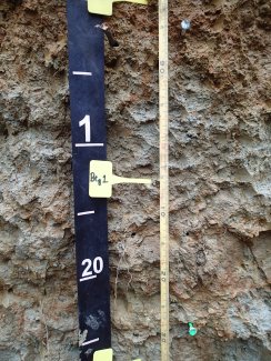
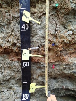
Megapit Images
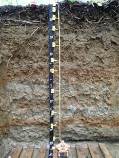
D02 SERC megapit soil profile 0-180 cm
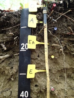
D02 SERC megapit soil profile 0-39 cm
D02 SERC megapit soil profile 21-62 cm
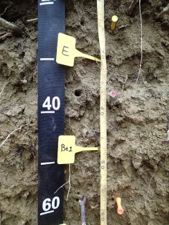
D02 SERC megapit soil profile 56-95 cm
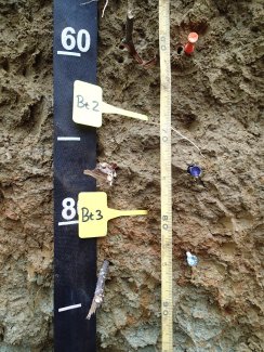
D02 SERC megapit soil profile 82-134 cm
D02 SERC megapit soil profile 128-180 cm
Megapit Pedon Description
| Print Date | Apr 8 2015 |
|---|---|
| Description Date | May 5 2014 |
| Describer | Jim Brewer |
| Site ID | S2014MD003001 |
| Pedon ID | S2014MD003001 |
| Lab Source ID | KSSL |
| Lab Pedon # | 14N0516 |
| Soil Name as Correlated | Adelphia |
| Classification | Fine-loamy, mixed, active, mesic Aquic Hapludults |
| Pedon Type | correlates to named soil |
| Pedon Purpose | research site |
| Taxon Kind | taxadjunct |
| Physiographic Division | Atlantic Plain |
| Physiographic Province | Coastal Plain |
| Physiographic Section | Embayed section |
| Geomorphic Setting | on talf flat on talf coastal plain |
| Particle Size Control Section | 37 to 87 cm. |
| Description origin | NASIS |
| Country | United States |
| State | Maryland |
| County | Anne Arundel |
| MLRA | 149A -- Northern Coastal Plain |
| Soil Survey Area | MD003 -- Anne Arundel County, Maryland 3-HAM -- Hammonton, New Jersey |
| Map Unit | CoC -- Collington-Wist complex, 5 to 10 percent slopes |
| Quad Name | South River, Maryland |
| Std Latitude | 38.8983028 |
| Std Longitude | -76.5588333 |
| Latitude | 38 degrees 53 minutes 53.89 seconds north |
| Longitude | 76 degrees 33 minutes 31.80 seconds west |
| Datum | NAD83 |
| UTM Zone | 18 |
| UTM Easting | 364821 meters |
| UTM Northing | 4306646 meters |
| Primary Earth Cover | Tree cover |
| Secondary Earth Cover | Intermixed conifers and hardwoods |
| Parent Material | glauconite bearing loamy marine deposits and/or fluviomarine deposits |
| Description database | KSSL |
| Diagnostic Features | ochric epipedon 0 to 37 cm. argillic horizon 37 to 147 cm. aquic conditions 37 to 200 cm. |
| Elevation (meters) | 10.6 |
| Aspect | 270 |
| Drainage Class | somewhat poorly |
| Horizon Details |
Oe--0 to 2 centimeters (0.0 to 0.8 inches); very dark grayish brown (10YR 3/2) moderately decomposed plant material; abrupt smooth boundary. Lab sample # 14N02749 A--2 to 13 centimeters (0.8 to 5.1 inches); very dark gray (10YR 3/1) loam; 10 percent clay; strong very fine subangular blocky, and strong fine subangular blocky structure; common very fine roots and common fine roots; abrupt wavy boundary. Lab sample # 14N02750 EA--13 to 23 centimeters (5.1 to 9.1 inches); yellowish brown (10YR 5/4) fine sandy loam; 12 percent clay; weak coarse subangular blocky, and weak medium subangular blocky structure; common very fine roots and common medium roots and common fine roots and common coarse roots; clear wavy boundary. Lab sample # 14N02751 E--23 to 37 centimeters (9.1 to 14.6 inches); brown (10YR 5/3) fine sandy loam; 15 percent clay; moderate fine single grain; common very fine roots and common medium roots and common fine roots; clear wavy boundary. Lab sample # 14N02752 Bt1--37 to 60 centimeters (14.6 to 23.6 inches); dark yellowish brown (10YR 4/4) sandy clay loam; 25 percent clay; weak medium prismatic parts to moderate medium subangular blocky structure; common very fine roots and common medium roots and common fine roots; 2 percent fine distinct irregular 7.5YR 5/4), moist, iron-manganese masses on faces of peds and 4 percent fine distinct irregular 7.5YR 6/2), moist, iron depletions on faces of peds; gradual wavy boundary. Lab sample # 14N02753 Bt2--60 to 75 centimeters (23.6 to 29.5 inches); dark yellowish brown (10YR 4/4) sandy clay loam; 25 percent clay; moderate medium prismatic parts to strong medium subangular blocky structure; common medium roots and common fine roots; 10 percent fine distinct irregular 7.5YR 6/2), moist, iron depletions on faces of peds and 15 percent fine distinct irregular 7.5YR 5/4), moist, iron-manganese masses on faces of peds; clear wavy boundary. Lab sample # 14N02754 Bt3--75 to 85 centimeters (29.5 to 33.5 inches); yellowish brown (10YR 5/4) loam; 25 percent clay; moderate medium prismatic parts to strong medium subangular blocky structure; common very fine roots; 20 percent fine distinct irregular 7.5YR 6/2), moist, iron depletions on faces of peds and 40 percent fine distinct irregular 5YR 5/4), moist, iron-manganese masses on faces of peds; clear smooth boundary. Lab sample # 14N02755 Btg1--85 to 131 centimeters (33.5 to 51.6 inches); light brownish gray (10YR 6/2) loam; 26 percent clay; moderate medium prismatic parts to strong medium subangular blocky structure; common very fine roots; 15 percent fine prominent irregular 5YR 6/6), moist, iron-manganese masses on faces of peds and 25 percent fine distinct irregular 5YR 6/3), moist, iron-manganese masses on faces of peds; clear wavy boundary. Lab sample # 14N02756 Btg2--131 to 147 centimeters (51.6 to 57.9 inches); light brownish gray (10YR 6/2) sandy clay loam; 25 percent clay; weak medium prismatic parts to moderate medium subangular blocky structure; common very fine roots; 15 percent fine prominent irregular 5YR 6/6), moist, iron-manganese masses on faces of peds and 25 percent fine distinct irregular 5YR 6/3), moist, iron-manganese masses on faces of peds. Lab sample # 14N02757 C--147 to 156 centimeters (57.9 to 61.4 inches); reddish yellow (5YR 7/6) loamy sand; 6 percent clay; structureless massive; common fine roots; 20 percent fine prominent irregular 5YR 4/1), moist, iron depletions and 25 percent fine distinct irregular 5YR 5/4), moist, iron-manganese masses. Lab sample # 14N02758 Cg--156 to 187 centimeters (61.4 to 73.6 inches); light gray (7.5YR 7/1) sandy loam; 13 percent clay; moderate medium platy structure; common fine roots; 15 percent fine prominent irregular 5YR 5/6), moist, iron-manganese masses; 8 percent nonflat subrounded indurated 2 to 5-millimeter quartzite fragments. Lab sample # 14N02759 C'--187 to 200 centimeters (73.6 to 78.7 inches); very dark gray (5Y 3/1) and 10Y 8/6 (10Y 8/6) and reddish yellow (5YR 6/8) stratified sand to loamy sand; structureless single grain; . Lab sample # 14N02760 |
Credits: This megapit soil pedon description was generously created by USDA Natural Resource Conservation Service staff, with particular thanks to Larry West, Jon Hempel, and numerous field staff.