Rocky Mountains NEON (RMNP) Soil Descriptions
Distributed Soils Reports
Pedon Descriptions
Pit‐level observations and field measurements reported using the standard NRCS format. They contain volume estimates for coarse fragments > 20 mm where applicable.
Site Level Plot Summary
A narrative summary that places the sampled soil pedons in the broader context of soils and geomorphology for the entire NEON site.
Megapit Images
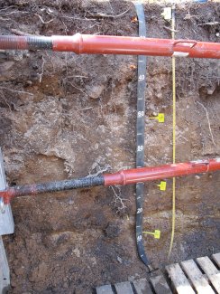
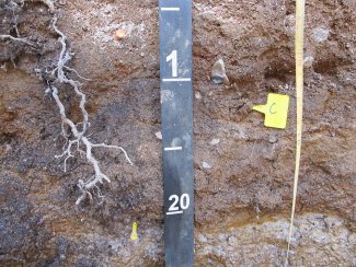
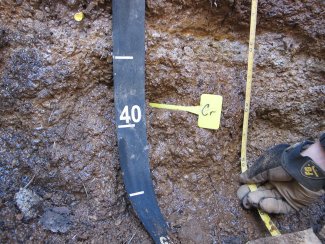
D10 RMNP megapit soil profile 0-155 cm
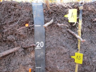
D10 RMNP megapit soil profile 0-33 cm
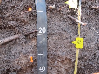
D10 RMNP megapit soil profile 5-43 cm
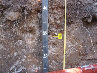
D10 RMNP megapit soil profile 34-92 cm
D10 RMNP megapit soil profile 90-127 cm
D10 RMNP megapit soil profil 124-155 cm
Megapit Pedon Description
| Print Date | Jul 22 2015 |
|---|---|
| Description Date | May 31 2013 |
| Describer | Andy Steinert |
| Site ID | 2013CO069001 |
| Site Note | Castnet NEON Soil Pit; This pedon has a seasonal, perched water table on top of the Cr horizon. This seasonal water table is from snow melt. There is no hydrophytic vegetation to suggest this is a permanent water table. |
| Pedon ID | S2013CO069001 |
| Pedon Note | The backhoe was able to scrape/dig through the Cr horizon, but not dig straight down. |
| Lab Source ID | SSL |
| Lab Pedon # | 13N61307 |
| Soil Name as Described/Sampled | Ustic Haplocryolls |
| Classification | Loamy-skeletal, mixed, superactive Ustic Haplocryolls |
| Pedon Purpose | laboratory sampling site |
| Taxon Kind | family |
| Physiographic Division | Rocky Mountain System |
| Physiographic Province | Southern Rocky Mountains |
| Geomorphic Setting | on mountainflank, lower third of mountains on mountain slope |
| Upslope Shape | convex |
| Cross Slope Shape | linear |
| Particle Size Control Section | 25 to 100 cm. |
| Description origin | NASIS |
| State | Colorado |
| County | Larimer |
| MLRA | 48A -- Southern Rocky Mountains |
| Soil Survey Area | 4-FTC -- Fort Collins, Colorado CO642 -- Estes Park Area, Colorado, Parts of Boulder and Larimer Counties |
| Map Unit | 7702B -- Frisco-Catamount, moist families complex, 5 to 40 percent slopes |
| Quad Name | Longs Peak, Colorado |
| Std Latitude | 40.2770556 |
| Std Longitude | -105.5452500 |
| Latitude | 40 degrees 16 minutes 37.40 seconds north |
| Longitude | 105 degrees 32 minutes 42.90 seconds west |
| Datum | WGS84 |
| UTM Zone | 13 |
| UTM Easting | 453647 meters |
| UTM Northing | 4458653 meters |
| Primary Earth Cover | Tree cover |
| Secondary Earth Cover | Conifers |
| Existing Vegetation | Arizona fescue, common juniper, Engelmann spruce, kinnikinnick, lodgepole pine, quaking aspen |
| Parent Material | residuum weathered from granite |
| Bedrock Kind | granite |
| Bedrock Depth | 123 centimeters |
| Bedrock Hardness | moderately cemented |
| Bedrock Fracture Interval | less than 10 centimeters |
| Surface Fragments | 2.0 percent nonflat subangular indurated 2- to 75-millimeter granite fragments and 3.0 percent nonflat subangular indurated 75- to 250-millimeter granite fragments |
| Description database | KSSL |
| Diagnostic Features | mollic epipedon 0 to 33 cm. paralithic contact 123 to 198 cm. lithic contact 198 to cm. |
| Top Depth (cm) | 123 |
| Bottom Depth (cm) | 198 |
| Restriction Kind | bedrock, paralithic |
| Restriction Hardness | moderately cemented |
| Top Depth (cm) | 198 |
| Bottom Depth (cm) | |
| Restriction Kind | bedrock, lithic |
| Restriction Hardness | indurated |
| Slope (%) | 3.0 |
| Elevation (meters) | 2,758.0 |
| Aspect (deg) | 46 |
| Drainage Class | moderately well |
| Horizon Details |
A--0 to 10 centimeters (0.0 to 3.9 inches); black (7.5YR 2.5/1) broken face loam, very dark gray (7.5YR 3/1) broken face, dry; 30 percent sand; 48 percent silt; 22 percent clay; weak fine granular structure; hard, very friable, slightly sticky, slightly plastic; common very fine roots throughout and common medium roots throughout and common fine roots throughout; 2 percent nonflat subangular indurated 2 to 5-millimeter granite fragments; noneffervescent, by HCl, 1 normal; moderately acid, pH 5.8, pH meter; a thin Oe horizon exists in places; clear smooth boundary. Lab sample # 13N06268 A--0 to 10 centimeters (0.0 to 3.9 inches); black (7.5YR 2.5/1) broken face loam, very dark gray (7.5YR 3/1) broken face, dry; 30 percent sand; 48 percent silt; 22 percent clay; weak fine granular structure; hard, very friable, slightly sticky, slightly plastic; common very fine roots throughout and common medium roots throughout and common fine roots throughout; 2 percent nonflat subangular indurated 2 to 5-millimeter granite fragments; noneffervescent, by HCl, 1 normal; moderately acid, pH 5.8, pH meter; a thin Oe horizon exists in places; clear smooth boundary. Lab sample # 13N06268 AB--10 to 33 centimeters (3.9 to 13.0 inches); very dark brown (10YR 2/2) broken face gravelly sandy clay loam, very dark grayish brown (10YR 3/2) broken face, dry; 65 percent sand; 13 percent silt; 22 percent clay; weak fine granular, and weak fine subangular blocky, and weak medium subangular blocky structure; very hard, very friable, slightly sticky, slightly plastic; common very fine roots throughout and common medium roots throughout and common fine roots throughout and common coarse roots throughout; 28 percent nonflat subangular indurated 2 to 20-millimeter granite fragments; noneffervescent, by HCl, 1 normal; slightly acid, pH 6.1, pH meter; clear wavy boundary. Lab sample # 13N06269 AB--10 to 33 centimeters (3.9 to 13.0 inches); very dark brown (10YR 2/2) broken face gravelly sandy clay loam, very dark grayish brown (10YR 3/2) broken face, dry; 65 percent sand; 13 percent silt; 22 percent clay; weak fine granular, and weak fine subangular blocky, and weak medium subangular blocky structure; very hard, very friable, slightly sticky, slightly plastic; common very fine roots throughout and common medium roots throughout and common fine roots throughout and common coarse roots throughout; 28 percent nonflat subangular indurated 2 to 20-millimeter granite fragments; noneffervescent, by HCl, 1 normal; slightly acid, pH 6.1, pH meter; clear wavy boundary. Lab sample # 13N06269 C/B--33 to 84 centimeters (13.0 to 33.1 inches); 60 percent dark yellowish brown (10YR 4/4) broken face gravelly loamy coarse sand, 60 percent light yellowish brown (10YR 6/4) broken face, dry; 80 percent sand; 16 percent silt; 4 percent clay; weak fine subangular blocky parts to weak fine granular, and weak medium subangular blocky parts to weak fine granular, and weak coarse subangular blocky parts to weak fine granular structure; soft, very friable, nonsticky, nonplastic; common medium roots throughout and common fine roots throughout; 2 percent nonflat subangular indurated 75 to 250-millimeter granite fragments and 32 percent nonflat subangular indurated 2 to 75-millimeter granite fragments; noneffervescent, by HCl, 1 normal; slightly acid, pH 6.1, pH meter; the C makes up 60% of this C/B horizon(all data for this row is for the C portion of this horizon). Lab sample # 13N06270 C/B--33 to 84 centimeters (13.0 to 33.1 inches); 60 percent dark yellowish brown (10YR 4/4) broken face gravelly loamy coarse sand, 60 percent light yellowish brown (10YR 6/4) broken face, dry; 80 percent sand; 16 percent silt; 4 percent clay; weak fine subangular blocky parts to weak fine granular, and weak medium subangular blocky parts to weak fine granular, and weak coarse subangular blocky parts to weak fine granular structure; soft, very friable, nonsticky, nonplastic; common medium roots throughout and common fine roots throughout; 2 percent nonflat subangular indurated 75 to 250-millimeter granite fragments and 32 percent nonflat subangular indurated 2 to 75-millimeter granite fragments; noneffervescent, by HCl, 1 normal; slightly acid, pH 6.1, pH meter; the C makes up 60% of this C/B horizon(all data for this row is for the C portion of this horizon). Lab sample # 13N06270 C/B--33 to 84 centimeters (13.0 to 33.1 inches); 40 percent very dark grayish brown (10YR 3/2) broken face gravelly coarse sandy loam, 40 percent grayish brown (10YR 5/2) broken face, dry; 70 percent sand; 12 percent silt; 18 percent clay; moderate medium subangular blocky parts to weak fine granular, and moderate coarse subangular blocky parts to weak fine granular structure; hard, very friable, slightly sticky, slightly plastic; common medium roots throughout and common fine roots throughout; 2 percent nonflat subangular indurated 75 to 250-millimeter granite fragments and 31 percent nonflat subangular indurated 2 to 75-millimeter granite fragments; noneffervescent, by HCl, 1 normal; moderately acid, pH 5.8, pH meter; the B makes up 40% of the C/B horizon(all data for this row relates to the B portion of the horizon); clear wavy boundary. Lab sample # 13N06271 C/B--33 to 84 centimeters (13.0 to 33.1 inches); 40 percent very dark grayish brown (10YR 3/2) broken face gravelly coarse sandy loam, 40 percent grayish brown (10YR 5/2) broken face, dry; 70 percent sand; 12 percent silt; 18 percent clay; moderate medium subangular blocky parts to weak fine granular, and moderate coarse subangular blocky parts to weak fine granular structure; hard, very friable, slightly sticky, slightly plastic; common medium roots throughout and common fine roots throughout; 2 percent nonflat subangular indurated 75 to 250-millimeter granite fragments and 31 percent nonflat subangular indurated 2 to 75-millimeter granite fragments; noneffervescent, by HCl, 1 normal; moderately acid, pH 5.8, pH meter; the B makes up 40% of the C/B horizon(all data for this row relates to the B portion of the horizon); clear wavy boundary. Lab sample # 13N06271 C--84 to 123 centimeters (33.1 to 48.4 inches); brown (7.5YR 4/4) broken face very gravelly coarse sand, light brown (7.5YR 6/4) broken face, dry; 90 percent sand; 8 percent silt; 2 percent clay; massive; soft, very friable, nonsticky, nonplastic; common medium roots throughout and common fine roots throughout; 47 percent nonflat subangular indurated 2 to 75-millimeter granite fragments; noneffervescent, by HCl, 1 normal; moderately acid, pH 6.0, pH meter; clear smooth boundary. Lab sample # 13N06272 C--84 to 123 centimeters (33.1 to 48.4 inches); brown (7.5YR 4/4) broken face very gravelly coarse sand, light brown (7.5YR 6/4) broken face, dry; 90 percent sand; 8 percent silt; 2 percent clay; massive; soft, very friable, nonsticky, nonplastic; common medium roots throughout and common fine roots throughout; 47 percent nonflat subangular indurated 2 to 75-millimeter granite fragments; noneffervescent, by HCl, 1 normal; moderately acid, pH 6.0, pH meter; clear smooth boundary. Lab sample # 13N06272 Cr--123 to 198 centimeters (48.4 to 78.0 inches); moderately cemented granite bedrock, fractured at intervals of less than 10 centimeters; very high excavation difficulty; 2 percent fine distinct 7.5YR 5/6) and 7.5YR 3/4) masses of oxidized iron at top of horizon and 3 percent medium distinct 7.5YR 5/6) and 7.5YR 3/4) masses of oxidized iron at top of horizon; noneffervescent, by HCl, 1 normal; some pockets of sandy clay material within Cr horizon. Lab sample # 13N06273 Cr--123 to 198 centimeters (48.4 to 78.0 inches); bedrock; very high excavation difficulty; 2 percent fine distinct 7.5YR 5/6) and 7.5YR 3/4) masses of oxidized iron at top of horizon and 3 percent medium distinct 7.5YR 5/6) and 7.5YR 3/4) masses of oxidized iron at top of horizon; noneffervescent, by HCl, 1 normal; some pockets of sandy clay material within Cr horizon. Lab sample # 13N06273 R--198 centimeters (78.0 inches); bedrock; extremely high excavation difficulty; noneffervescent, by HCl, 1 normal. R--198 centimeters (78.0 inches); indurated granite bedrock; extremely high excavation difficulty; noneffervescent, by HCl, 1 normal. |
Credits: This megapit soil pedon description was generously created by USDA Natural Resource Conservation Service staff, with particular thanks to Larry West, Jon Hempel, and numerous field staff.