Oak Ridge NEON (ORNL) Soil Descriptions
Distributed Soils Reports
Pedon Descriptions
Pit‐level observations and field measurements reported using the standard NRCS format. They contain volume estimates for coarse fragments > 20 mm where applicable.
Site Level Plot Summary
A narrative summary that places the sampled soil pedons in the broader context of soils and geomorphology for the entire NEON site.
Megapit Images
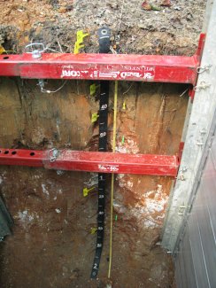
D07 ORNL megapit soil profile 0-200 cm
D07 ORNL megapit soil profile 11-128 cm
D07 ORNL megapit soil profile 73-193 cm
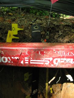
D07 ORNL megapit soil profile 0-3 cm
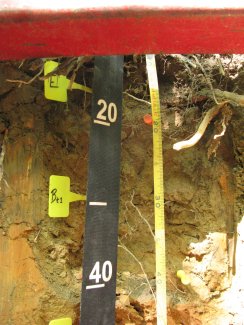
D07 ORNL megapit soil profile 9-45 cm
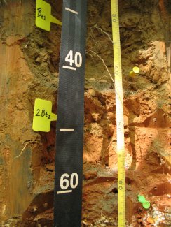
D07 ORNL megapit soil profile 27-67 cm
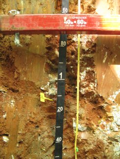
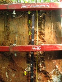
D07 ORNL megapit soil profile 55-153 cm
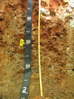
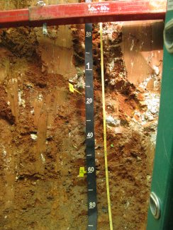
D07 ORNL megapit soil profile 124-200 cm
Megapit Pedon Description
| Print Date | Jul 22 2015 |
|---|---|
| Description Date | Sep 23 2013 |
| Describer | D. Moore, J. Mason, N. Hartgrove, B. Esham |
| Site ID | S2013TN001001 |
| Site Note | This is a long term ecological monitoring plot being installed by the National Ecological Observatory Network (NEON). The existing vegetation at the site consists of northern red oak, chestnut oak, red maple, virginia pine, hickory, yellow poplar, sassafras, serviceberry, christmas fern. |
| Pedon ID | S2013TN001001 |
| Lab Source ID | KSSL |
| Lab Pedon # | 14N0042 |
| Soil Name as Described/Sampled | Fullerton |
| Classification | Fine, kaolinitic, thermic Typic Paleudults |
| Pedon Type | undefined observation |
| Pedon Purpose | research site |
| Taxon Kind | series |
| Physiographic Division | Appalachian Highlands |
| Physiographic Province | Valley and Ridge Province |
| Physiographic Section | Tennessee section |
| Geomorphic Setting | on shoulder of crest of river valley on ridge |
| Upslope Shape | convex |
| Cross Slope Shape | concave |
| Particle Size Control Section | 19 to 69 cm. |
| Description origin | NASIS |
| Country | United States |
| State | Tennessee |
| County | Anderson |
| MLRA | 128 -- Southern Appalachian Ridges and Valleys |
| Soil Survey Area | TN001 -- Anderson County, Tennessee 6-KNO -- Knoxville, Tennessee |
| Map Unit | FoC -- Fullerton-Pailo complex, 5 to 12 percent slopes |
| Quad Name | Bethel Valley, Tennessee |
| Std Latitude | 35.9645830 |
| Std Longitude | -84.2828060 |
| Latitude | 35 degrees 57 minutes 52.50 seconds north |
| Longitude | 84 degrees 16 minutes 58.10 seconds west |
| Datum | WGS84 |
| UTM Zone | 16 |
| UTM Easting | 745032 meters |
| UTM Northing | 3983434 meters |
| Primary Earth Cover | Tree cover |
| Secondary Earth Cover | Hardwoods |
| Parent Material | loamy colluvium derived from cherty limestone over clayey residuum weathered from cherty limestone |
| Description database | KSSL |
| Diagnostic Features | ochric epipedon 0 to 19 cm. argillic horizon 19 to 180 cm. |
| Slope (%) | 6.0 |
| Elevation (meters) | 348.0 |
| Aspect (deg) | 18 |
| Drainage Class | well |
| Horizon Details |
Oi--0 to 1 centimeters (0.0 to 0.4 inches); moderately decomposed plant material; . Lab sample # 14N00163 A--1 to 10 centimeters (0.4 to 3.9 inches); very dark grayish brown (10YR 3/2) silt loam; weak fine granular structure; very friable; many very fine roots and few medium roots and many fine roots; 10 percent nonflat subrounded strongly cemented 2 to 38-millimeter chert fragments; abrupt smooth boundary. Lab sample # 14N00164 E--10 to 19 centimeters (3.9 to 7.5 inches); brown (10YR 4/3) gravelly silt loam; weak fine subangular blocky structure; very friable; many very fine roots and many medium roots and common fine roots; tubular and dendritic tubular pores; 18 percent nonflat subrounded very strongly cemented 2 to 76-millimeter chert fragments; very strongly acid, pH 4.5, pH indicator solutions; clear smooth boundary. Lab sample # 14N00165 Bt1--19 to 40 centimeters (7.5 to 15.7 inches); yellowish brown (10YR 5/4) gravelly silty clay loam; 28 percent clay; 15 percent medium faint (10YR 5/6) mottles; moderate medium subangular blocky structure; friable; common very fine roots and common fine roots; 30 percent faint clay films; 18 percent nonflat subrounded very strongly cemented 2 to 76-millimeter chert fragments; very strongly acid, pH 4.5, pH indicator solutions; clear smooth boundary. Lab sample # 14N00166 2Bt2--40 to 65 centimeters (15.7 to 25.6 inches); yellowish red (5YR 5/6) silty clay loam; 37 percent clay; 25 percent coarse distinct (7.5YR 6/6) mottles; moderate medium subangular blocky structure; friable; few fine roots; 60 percent distinct clay films; 5 percent nonflat subrounded very strongly cemented 2 to 76-millimeter chert fragments; very strongly acid, pH 4.5, pH indicator solutions; clear smooth boundary. Lab sample # 14N00167 2Bt3--65 to 147 centimeters (25.6 to 57.9 inches); red (2.5YR 4/6) extremely cobbly clay; 53 percent clay; strong medium angular blocky structure; firm; few very fine roots and few fine roots; 60 percent distinct clay films; 15 percent nonflat subangular very strongly cemented 2 to 76-millimeter chert fragments and 47 percent nonflat subrounded very strongly cemented 76 to 250-millimeter chert fragments; very strongly acid, pH 4.5, pH indicator solutions; gradual smooth boundary. Lab sample # 14N00168 2Bt4--147 to 180 centimeters (57.9 to 70.9 inches); red (2.5YR 5/6) extremely gravelly clay; 55 percent clay; 15 percent medium distinct (5YR 5/8) and 15 percent medium prominent (7.5YR 6/8) mottles; strong medium angular blocky structure; firm; 60 percent distinct clay films; 10 percent nonflat subrounded very strongly cemented 76 to 250-millimeter chert fragments and 55 percent nonflat subangular very strongly cemented 2 to 76-millimeter chert fragments; very strongly acid, pH 4.5, pH indicator solutions. Lab sample # 14N00169 |
Credits: This megapit soil pedon description was generously created by USDA Natural Resource Conservation Service staff, with particular thanks to Larry West, Jon Hempel, and numerous field staff.