Niwot Ridge NEON (NIWO) Soil Descriptions
Distributed Soils Reports
Pedon Descriptions
Pit‐level observations and field measurements reported using the standard NRCS format. They contain volume estimates for coarse fragments > 20 mm where applicable.
Site Level Plot Summary
A narrative summary that places the sampled soil pedons in the broader context of soils and geomorphology for the entire NEON site.
Megapit Images
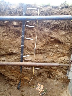
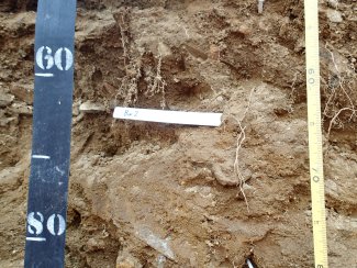
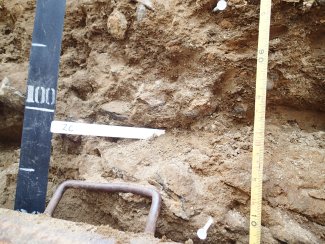
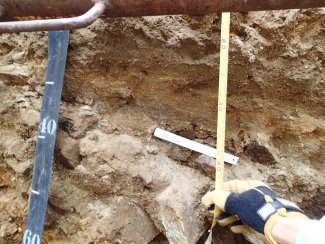
D13 NIWO megapit soil profile 0-200 cm
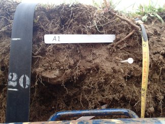
D13 NIWO megapit soil profile 0-25 cm
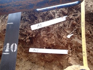
D13 NIWO megapit soil profile 024-44 cm
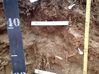
D13 NIWO megapit soil profile 33-60 cm
D13 NIWO megapit soil profile 53-79 cm
D13 NIWO megapit soil profile 84-133 cm
D13 NIWO megapit soil profile 84-113 cm
Megapit Pedon Description
| Print Date | Jul 22 2015 |
|---|---|
| Description Date | Aug 19 2014 |
| Describer | Andy Steinert, Clark Harshbarger, Willian Shoup |
| Site ID | 2014CO013001 |
| Site Note | This site is the location of the Niwot Ridge NEON (National Ecological Observatory Network) site. All location information was measured at the soil pit. |
| Pedon ID | S2014CO013501 |
| Pedon Note | At the time of this description there were no series to fit the classification of coarse-loamy, mixed, superactive Typic Haplocryolls. The best fit at this time was to use the 'taxon above family' and call it the Moran Family from the map unit, Moran family-Lithic Cryorthents-Rubble land complex, 5 to 40 percent slopes (MUSYM 8776B). The soil pit was located within this map unit. The Moran family is classified as a loamy-skeletal, mixed, superactive Humic Dystrocryepts in the Arapahoe-Roosevelt National Forest Soil Survey (v3, Dec. 23, 2013). The differences in this pedon are the amount of rock fragments, the paralithic contact, and the mollic epipedon. This pedon has a paralithic contact at 110 centimenters and the rock fragments are less than 35 percent in the particle size control section. The mollic epipedon was very high in organic matter (decompossed) and would be similar to the 'Humic' subgroup for the Dystrocryepts. Please note, that the classification on the OSD for the Moran series has been updated to loamy-skeletal, mixed, superactive Typic Humicryepts. |
| Lab Source ID | KSSL |
| Lab Pedon # | 14N0993 |
| Soil Name as Described/Sampled | Moran |
| Classification | Coarse-loamy, mixed, superactive Typic Haplocryolls |
| Pedon Type | undefined observation |
| Pedon Purpose | research site |
| Taxon Kind | taxon above family |
| Associated Soils | Leighcan family, Lithic Cryorthents, Moran family |
| Physiographic Division | Rocky Mountain System |
| Physiographic Province | Southern Rocky Mountains |
| Local Physiographic Area | Niwot Ridge |
| Geomorphic Setting | on mountainflank, center third of mountain slope on mountain range |
| Upslope Shape | convex |
| Cross Slope Shape | convex |
| Particle Size Control Section | 25 to 100 cm. |
| Description origin | NASIS |
| State | Colorado |
| County | Boulder |
| MLRA | 48A -- Southern Rocky Mountains |
| Soil Survey Area | CO645 -- Arapaho-Roosevelt National Forest Area, Colorado, Parts of Boulder, Clear Creek, Gilpin, Grand, Park and Larimer Counties 4-FTC -- Fort Collins, Colorado |
| Map Unit | 8776B -- Moran family-Lithic Cryorthents-Rubble land complex, 5 to 40 percent slopes |
| Quad Name | Ward, Colorado |
| Std Latitude | 40.0523600 |
| Std Longitude | -105.5832400 |
| Latitude | 40 degrees 3 minutes 8.50 seconds north |
| Longitude | 105 degrees 34 minutes 59.70 seconds west |
| Datum | WGS84 |
| UTM Zone | 13 |
| UTM Easting | 450252 meters |
| UTM Northing | 4433732 meters |
| Primary Earth Cover | Grass/herbaceous cover |
| Secondary Earth Cover | Tundra rangeland |
| Existing Vegetation | alpine bluegrass, alpine clover, alpine sagebrush, elk sedge, Fern or Fern Ally, fir, moss campion, phlox, Pyrenean sedge, Ross' avens, snow cinquefoil, timber oatgrass |
| Parent Material | glaciofluvial deposits over residuum weathered from granite, gneiss, schist |
| Bedrock Kind | granite |
| Bedrock Depth | 110 centimeters |
| Bedrock Hardness | indurated |
| Surface Fragments | 3.0 percent nonflat subangular indurated 2- to 75-millimeter granite fragments |
| Description database | KSSL |
| Diagnostic Features | mollic epipedon 0 to 30 cm. cambic horizon 30 to 79 cm. paralithic contact 110 to cm. |
| Top Depth (cm) | 110 |
| Restriction Kind | bedrock, paralithic |
| Slope (%) | 13.0 |
| Elevation (meters) | 3,474.0 |
| Aspect (deg) | 135 |
| Drainage Class | well |
| Horizon Details |
A1--0 to 14 centimeters (0.0 to 5.5 inches); black (7.5YR 2.5/1) broken face loam, brown (7.5YR 4/2) broken face, dry; 45 percent sand; 40 percent silt; 15 percent clay; moderate medium granular, and weak fine subangular blocky structure; soft, very friable, nonsticky, nonplastic; many very fine roots throughout and common medium roots throughout and common fine roots throughout; 3 percent nonflat subrounded indurated 2 to 75-millimeter granite fragments; noneffervescent, by HCl, 1 normal; strongly acid, pH 5.3, pH meter; this horizon is very high in highly decompossed organic matter; clear smooth boundary. Lab sample # 14N04815 A2--14 to 30 centimeters (5.5 to 11.8 inches); dark brown (7.5YR 3/2) broken face loam, brown (7.5YR 4/2) broken face, dry; 45 percent sand; 40 percent silt; 15 percent clay; moderate medium granular, and weak fine subangular blocky, and moderate fine granular structure; soft, very friable, nonsticky, nonplastic; many very fine roots throughout and common medium roots throughout and common fine roots throughout; 3 percent nonflat subrounded indurated 2 to 75-millimeter granite fragments; noneffervescent, by HCl, 1 normal; strongly acid, pH 5.3, pH meter; gradual wavy boundary. Lab sample # 14N04816 Bw1--30 to 49 centimeters (11.8 to 19.3 inches); brown (7.5YR 4/3) broken face gravelly sandy loam, dark yellowish brown (10YR 4/4) broken face, dry; 70 percent sand; 22 percent silt; 8 percent clay; weak medium subangular blocky, and weak coarse subangular blocky structure; slightly hard, very friable, nonsticky, nonplastic; common very fine roots throughout and common medium roots throughout and common fine roots throughout; 1 percent nonflat subrounded indurated 380 to 600-millimeter granite fragments and 2 percent nonflat subrounded indurated 76 to 250-millimeter granite fragments and 20 percent nonflat subrounded indurated 2 to 75-millimeter granite fragments; noneffervescent, by HCl, 1 normal; strongly acid, pH 5.4, pH meter; this horizon has a partial stone line that is very gravelly to extremely gravelly in the left side of the pit, it does not show on the right side of the pit; gradual wavy boundary. Lab sample # 14N04817 Bw2--49 to 79 centimeters (19.3 to 31.1 inches); brown (7.5YR 4/4) broken face sandy loam, yellowish brown (10YR 5/4) broken face, dry; 70 percent sand; 22 percent silt; 8 percent clay; weak very coarse subangular blocky, and weak coarse subangular blocky structure; slightly hard, very friable, nonsticky, nonplastic; common very fine roots throughout and common fine roots throughout; common very fine pores; 1 percent nonflat subrounded indurated 380 to 600-millimeter granite fragments and 2 percent nonflat subrounded indurated 76 to 250-millimeter granite fragments and 8 percent nonflat subrounded indurated 2 to 75-millimeter granite fragments; noneffervescent, by HCl, 1 normal; strongly acid, pH 5.4, pH meter; gradual wavy boundary. Lab sample # 14N04818 2C--79 to 110 centimeters (31.1 to 43.3 inches); brown (7.5YR 4/4) broken face sandy loam, yellowish brown (10YR 5/4) broken face, dry; 75 percent sand; 17 percent silt; 8 percent clay; massive; soft, very friable, nonsticky, nonplastic; common very fine roots throughout; 1 percent nonflat subrounded indurated 380 to 600-millimeter granite fragments and 5 percent nonflat subrounded indurated 76 to 250-millimeter granite fragments and 7 percent nonflat subrounded indurated 2 to 75-millimeter granite fragments; noneffervescent, by HCl, 1 normal; moderately acid, pH 5.6, pH meter; gradual wavy boundary. Lab sample # 14N04819 2(C)/Cr--110 to 200 centimeters (43.3 to 78.7 inches); indurated granite bedrock; This horizon has a good example of the uplift of the granite, gniess, and schist in this area. The paralithic material (Cr) is angled upward in the lower left-hand part of the pit, while the C and Cr material in the right-hand side of the it is relatively horizontal. It was very evident in the pit that the Cr and C material at one point in time was horizontal and connected. Lab sample # 14N04820 2C/(Cr)--110 to 200 centimeters (43.3 to 78.7 inches); brown (7.5YR 4/4) broken face loamy sand, light yellowish brown (10YR 6/4) broken face, dry; 80 percent sand; 14 percent silt; 6 percent clay; 2 percent coarse prominent (7.5YR 6/8) and 3 percent medium prominent (7.5YR 6/8) mottles; massive; soft, very friable, nonsticky, nonplastic; 1 percent nonflat subrounded indurated 380 to 600-millimeter granite fragments and 2 percent nonflat subrounded indurated 76 to 250-millimeter granite fragments and 5 percent nonflat subrounded indurated 2 to 75-millimeter granite fragments; noneffervescent, by HCl, 1 normal; moderately acid, pH 5.9, pH meter. Lab sample # 14N04820 |
Credits: This megapit soil pedon description was generously created by USDA Natural Resource Conservation Service staff, with particular thanks to Larry West, Jon Hempel, and numerous field staff.