NSF NEON, Operated by Battelle

Main navigation

  • About
    • NEON Overview
      • Vision and Management
      • Spatial and Temporal Design
      • History
    • About the NEON Biorepository
      • ASU Biorepository Staff
      • Contact the NEON Biorepository
    • Observatory Blog
    • Newsletters
    • Staff
    • FAQ
    • Contact Us

    About

  • Data
    • Data Portal
      • Data Availability Charts
      • API & GraphQL
      • Prototype Data
      • Externally Hosted Data
    • Data Collection Methods
      • Airborne Observation Platform (AOP)
      • Instrument System (IS)
        • Instrumented Collection Types
        • Aquatic Instrument System (AIS)
        • Terrestrial Instrument System (TIS)
      • Observational System (OS)
        • Observation Types
        • Observational Sampling Design
        • Sampling Schedules
        • Taxonomic Lists Used by Field Staff
        • Optimizing the Observational Sampling Designs
      • Protocols & Standardized Methods
    • Getting Started with NEON Data
      • neonUtilities for R and Python
      • Learning Hub
      • Code Hub
    • Using Data
      • Data Formats and Conventions
      • Released, Provisional, and Revised Data
      • Data Product Bundles
      • Usage Policies
      • Acknowledging and Citing NEON
      • Publishing Research Outputs
    • Data Notifications
    • NEON Data Management
      • Data Availability
      • Data Processing
      • Data Quality

    Data

  • Samples & Specimens
    • Biorepository Sample Portal at ASU
    • About Samples
      • Sample Types
      • Sample Repositories
      • Megapit and Distributed Initial Characterization Soil Archives
    • Finding and Accessing Sample Data
      • Species Checklists
      • Sample Explorer - Relationships and Data
      • Biorepository API
    • Requesting and Using Samples
      • Loans & Archival Requests
      • Usage Policies

    Samples & Specimens

  • Field Sites
    • Field Site Map and Info
    • Spatial Layers & Printable Maps

    Field Sites

  • Resources
    • Getting Started with NEON Data
    • Research Support Services
      • Field Site Coordination
      • Letters of Support
      • Mobile Deployment Platforms
      • Permits and Permissions
      • AOP Flight Campaigns
      • Research Support FAQs
      • Research Support Projects
    • Code Hub
      • neonUtilities for R and Python
      • Code Resources Guidelines
      • Code Resources Submission
      • NEON's GitHub Organization Homepage
    • Learning Hub
      • Tutorials
      • Workshops & Courses
      • Science Videos
      • Teaching Modules
    • Science Seminars and Data Skills Webinars
    • Document Library
    • Funding Opportunities

    Resources

  • Impact
    • Research Highlights
    • Papers & Publications
    • NEON in the News

    Impact

  • Get Involved
    • Upcoming Events
    • Research and Collaborations
      • Environmental Data Science Innovation and Inclusion Lab
      • Collaboration with DOE BER User Facilities and Programs
      • EFI-NEON Ecological Forecasting Challenge
      • NEON Great Lakes User Group
      • NCAR-NEON-Community Collaborations
    • Advisory Groups
      • Science, Technology & Education Advisory Committee
      • Technical Working Groups
    • NEON Ambassador Program
      • Exploring NEON-Derived Data Products Workshop Series
    • Partnerships
    • Community Engagement
    • Work Opportunities

    Get Involved

  • My Account
  • Search

Search

Breadcrumb

  1. Data Collection Methods
  2. Soils
  3. Soil Descriptions
  4. Mountain Lake Biological Station NEON (MLBS) Soil Descriptions

Mountain Lake Biological Station NEON (MLBS) Soil Descriptions

Distributed Soils Reports

Pedon Descriptions

Pit‐level observations and field measurements reported using the standard NRCS format. They contain volume estimates for coarse fragments > 20 mm where applicable.

Download

Site Level Plot Summary

A narrative summary that places the sampled soil pedons in the broader context of soils and geomorphology for the entire NEON site.

Download

Megapit Images

soil profile

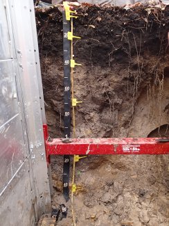
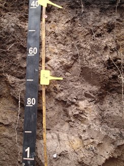
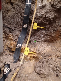
D07 MLBS megapit soil profile 0-150 cm

soil profile

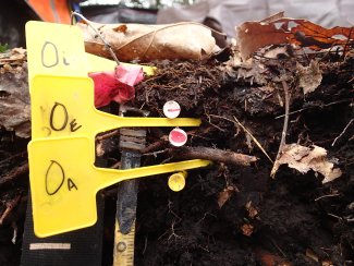
D07 MLBS megapit soil profile 0-11 cm

soil profile

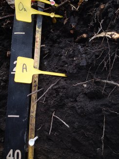
D07 MLBS megapit soil profile 2-39 cm

soil profile

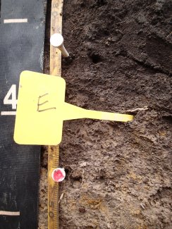
D07 MLBS megapit soil profile 30-51 cm

soil profile

D07 MLBS megapit soil profile 40-102 cm

soil profile

D07 MLBS megapit soil profile 98-150 cm

Download All Images

Megapit Pedon Description

Print Date Jul 22 2015
Description Date Dec 2 2013
Describer R. Pate and J.C. Freyman
Site ID S201351071001
Pedon ID S2013VA071001
Lab Source ID KSSL
Lab Pedon # 14N0249
Soil Name as Described/Sampled SND
Classification Coarse-loamy, siliceous, semiactive, frigid Fluvaquents
Pedon Type undefined observation
Pedon Purpose research site
Taxon Kind family
Geomorphic Setting ridge
Description origin NASIS
Quad Name Interior, Virginia
Latitude 37 degrees 22 minutes 40.20 seconds north
Longitude 80 degrees 31 minutes 27.30 seconds west
Datum NAD83
Existing Vegetation eastern white pine, hemlock, mountain laurel, northern red oak, pitch pine, red maple, striped maple, white oak
Description database KSSL
Horizon Details

Oi--0 to 5 centimeters (0.0 to 2.0 inches); slightly decomposed plant material; 0 percent unspecified fragments; abrupt smooth boundary. Lab sample # 14N00748

Oe--5 to 8 centimeters (2.0 to 3.1 inches); moderately decomposed plant material; very fine roots; 0 percent unspecified fragments; abrupt smooth boundary. Lab sample # 14N00740

Oa--8 to 11 centimeters (3.1 to 4.3 inches); highly decomposed plant material; very fine roots and medium roots and fine roots; 0 percent unspecified fragments; abrupt smooth boundary. Lab sample # 14N00741 A--11 to 44 centimeters (4.3 to 17.3 inches); black (10YR 2/1) sandy loam; moderate fine granular, and weak coarse subangular blocky structure; medium roots and fine roots and coarse roots; 0 percent unspecified fragments; abrupt smooth boundary. Lab sample # 14N00742

E--44 to 56 centimeters (17.3 to 22.0 inches); loam; weak coarse subangular blocky structure; fine roots; 0 percent unspecified fragments; abrupt smooth boundary. Lab sample # 14N00743

Bw1--56 to 105 centimeters (22.0 to 41.3 inches); loam; weak medium subangular blocky structure; very fine roots and fine roots; 15 percent medium distinct 5YR 5/4), moist, iron-manganese masses with clear boundaries in matrix and 85 percent coarse faint 10YR 5/2), moist, clay depletions with diffuse boundaries in matrix; 0 percent unspecified fragments; gradual wavy boundary. Lab sample # 14N00744

Bw2--105 to 140 centimeters (41.3 to 55.1 inches); loam; weak very coarse subangular blocky structure; very fine roots; 0 percent unspecified fragments; gradual irregular boundary. Lab sample # 14N00745

2C1--140 to 165 centimeters (55.1 to 65.0 inches); sandy clay loam; structureless coarse single grain; very few roots; 15 percent nonflat subangular sandstone fragments; abrupt smooth boundary. Lab sample # 14N00746

2Cg2--165 to 205 centimeters (65.0 to 80.7 inches); sandy clay; structureless very fine massive; very few roots; 25 percent nonflat subangular sandstone fragments; abrupt smooth boundary. Lab sample # 14N00747

Credits: This megapit soil pedon description was generously created by USDA Natural Resource Conservation Service staff, with particular thanks to Larry West, Jon Hempel, and numerous field staff.

NSF NEON, Operated by Battelle

Follow Us:

Join Our Newsletter

Get updates on events, opportunities, and how NEON is being used today.

Subscribe Now

Footer

  • About Us
  • Contact Us
  • Terms & Conditions
  • Careers
  • Code of Conduct

Copyright © Battelle, 2026

The National Ecological Observatory Network is a major facility fully funded by the U.S. National Science Foundation.

Any opinions, findings and conclusions or recommendations expressed in this material do not necessarily reflect the views of the U.S. National Science Foundation.