Lenoir Landing NEON (LENO) Soil Descriptions
Distributed Soils Reports
Pedon Descriptions
Pit‐level observations and field measurements reported using the standard NRCS format. They contain volume estimates for coarse fragments > 20 mm where applicable.
Site Level Plot Summary
A narrative summary that places the sampled soil pedons in the broader context of soils and geomorphology for the entire NEON site.
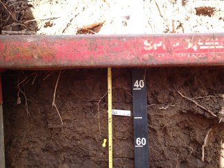
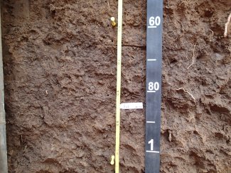
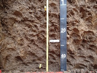
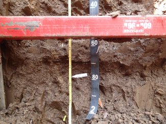
Megapit Images
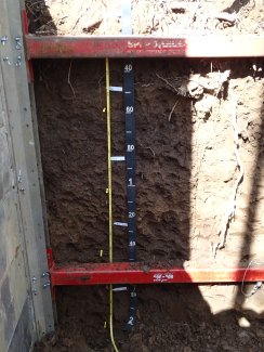
D08 LENO megapit soil profile 0-200 cm
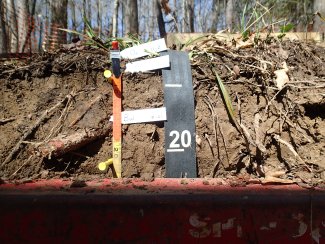
D08 LENO megapit soil profile 0-23 cm
D08 LENO megapit soil profile 32-67 cm
D08 LENO megapit soil profile 54-107 cm
D08 LENO megapit soil 97-149 cm
D08 LENO megapit soil profile 137-200 cm
Megapit Pedon Description
| Print Date | Feb 18 2016 |
|---|---|
| Description Date | Mar 17 2015 |
| Describer | C. Hatcher, J. Velazquez |
| Site ID | S2015AL023004 |
| Pedon ID | S2015AL023004 |
| Lab Source ID | KSSL |
| Lab Pedon # | 15N0527 |
| Soil Name as Described/Sampled | Urbo |
| Classification | Fine, mixed, active, acid, thermic Vertic Epiaquepts |
| Pedon Type | confirmation description |
| Pedon Purpose | ecological site data |
| Taxon Kind | series |
| Associated Soils | Annemaine, Bigbee, Cahaba, Latonia, Lenoir, Mooreville, Riverview, Una |
| Local Physiographic Area | Tombigbee River Floodplain |
| Geomorphic Setting | on talf alluvial plain on talf flood plain |
| Upslope Shape | linear |
| Cross Slope Shape | linear |
| Particle Size Control Section | 8 to 84 cm. |
| Description origin | NASIS |
| Country | United States |
| State | Alabama |
| County | Choctaw |
| MLRA | 133A -- Southern Coastal Plain |
| Soil Survey Area | AL023 -- Choctaw County, Alabama 7-MER -- Meridian, Mississippi |
| Map Unit | UrB -- Urbo-Mooreville-Una complex, gently undulating, frequently flooded |
| Quad Name | Coffeeville Lock And Dam, Alabama |
| Std Latitude | 31.8531111 |
| Std Longitude | -88.1610278 |
| Latitude | 31 degrees 51 minutes 11.20 seconds north |
| Longitude | 88 degrees 9 minutes 39.70 seconds west |
| Datum | WGS84 |
| UTM Zone | 16 |
| UTM Easting | 390157 meters |
| UTM Northing | 3524742 meters |
| Primary Earth Cover | Tree cover |
| Secondary Earth Cover | Intermixed conifers and hardwoods |
| Parent Material | clayey alluvium |
| Description database | KSSL |
| Diagnostic Features | fibers 0 to 2 cm. ochric epipedon 2 to 8 cm. cambic horizon 8 to 21 cm. aquic conditions 21 to 203 cm. |
| Slope (%) | 1.0 |
| Elevation (meters) | 8.0 |
| Aspect (deg) | 270 |
| MAAT (C) | 18.0 |
| MSAT (C) | 28.2 |
| MWAT (C) | 9.2 |
| MAP (mm) | 1,448 |
| Frost-Free Days | 250 |
| Drainage Class | somewhat poorly |
| Slope Length (meters) | 100 |
| Upslope Length (meters) | 100.0 |
| Horizon Details |
Oi--0 to 2 centimeters (0.0 to 0.8 inches); very dark brown (10YR 2/2); friable; deformable; many very fine roots throughout and common very coarse roots throughout and many medium roots throughout and many fine roots throughout and common coarse roots throughout; 75.0 percent after rubbing Fibric Materials; very abrupt smooth boundary. Lab sample # 15N02698 A--2 to 8 centimeters (0.8 to 3.1 inches); dark grayish brown (10YR 4/2) loam; weak fine granular structure; very friable, nonsticky, nonplastic; semideformable; many very fine roots throughout and many medium roots throughout and many fine roots throughout and common coarse roots throughout and common coarse roots throughout; clear smooth boundary. Lab sample # 15N02699 Bw--8 to 21 centimeters (3.1 to 8.3 inches); dark yellowish brown (10YR 4/4) loam; weak fine subangular blocky, and weak medium subangular blocky structure; friable, slightly sticky, slightly plastic; nonfluid; few very coarse roots throughout and common medium roots throughout and few coarse roots throughout; few fine dendritic tubular pores; 15 percent medium faint irregular 10YR 4/3), moist, masses of oxidized iron with clear boundaries in matrix and 15 percent medium distinct irregular 10YR 5/6), moist, masses of oxidized iron with clear boundaries in matrix; clear wavy boundary. Lab sample # 15N02700 Bg1--21 to 58 centimeters (8.3 to 22.8 inches); dark grayish brown (10YR 4/2) clay loam; weak medium subangular blocky structure; firm, moderately sticky, moderately plastic; nonfluid; few medium roots throughout and few fine roots throughout; 15 percent medium faint irregular 10YR 4/3), moist, masses of oxidized iron with clear boundaries in matrix and 15 percent medium distinct irregular 10YR 6/2), moist, masses of reduced iron with clear boundaries in matrix and 15 percent medium distinct irregular 2.5Y 5/2), moist, masses of reduced iron with clear boundaries in matrix; gradual wavy boundary. Lab sample # 15N02701 Bg2--58 to 102 centimeters (22.8 to 40.2 inches); dark grayish brown (10YR 4/2) clay loam; weak medium subangular blocky structure; firm, moderately sticky, moderately plastic; nonfluid; few very fine roots throughout; 15 percent medium faint irregular 10YR 5/6), moist, masses of oxidized iron with clear boundaries in matrix and 15 percent medium distinct irregular 2.5Y 6/2), moist, masses of reduced iron with clear boundaries in matrix; gradual wavy boundary. Lab sample # 15N02702 Bg3--102 to 147 centimeters (40.2 to 57.9 inches); dark yellowish brown (10YR 4/4) silty clay; weak medium subangular blocky structure; firm, moderately sticky, moderately plastic; nonfluid; 15 percent medium prominent irregular 7.5YR 5/8), moist, masses of oxidized iron with clear boundaries in matrix and 15 percent medium faint irregular 10YR 5/6), moist, masses of oxidized iron with clear boundaries in matrix and 25 percent medium distinct irregular 2.5Y 6/2), moist, masses of reduced iron with clear boundaries in matrix; gradual wavy boundary. Lab sample # 15N02703 Bg4--147 to 203 centimeters (57.9 to 79.9 inches); dark brown (10YR 3/3) clay; weak medium subangular blocky structure; firm, very sticky, very plastic; nonfluid; 15 percent medium faint irregular 10YR 4/4), moist, masses of oxidized iron with clear boundaries in matrix and 25 percent medium distinct irregular 10YR 6/2), moist, masses of reduced iron with clear boundaries in matrix. Lab sample # 15N02704. |
Credits: This megapit soil pedon description was generously created by USDA Natural Resource Conservation Service staff, with particular thanks to Larry West, Jon Hempel, and numerous field staff.