Konza Prairie Biological Station NEON (KONZ) Soil Descriptions
Distributed Soils Reports
Pedon Descriptions
Pit‐level observations and field measurements reported using the standard NRCS format. They contain volume estimates for coarse fragments > 20 mm where applicable.
Site Level Plot Summary
A narrative summary that places the sampled soil pedons in the broader context of soils and geomorphology for the entire NEON site.
Megapit Images
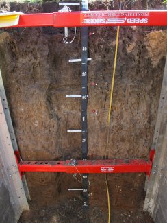
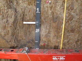
D06 KONZ megapit soil profile 0-200 cm

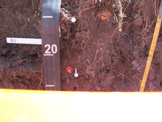
D06 KONZ megapit soil profile 0-22 cm
D05 KONZ megapit soil profile 5-31 cm
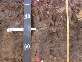
D06 KONZ megapit soil profile 28-68 cm
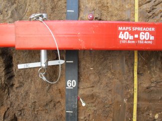
D06 KONZ megapit soil profile 62-100 cm
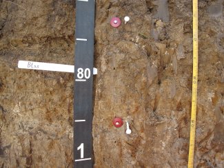
D06 KONZ megapit soil profile 89-136 cm
D06 KONZ megapit soil profile 126-171 cm
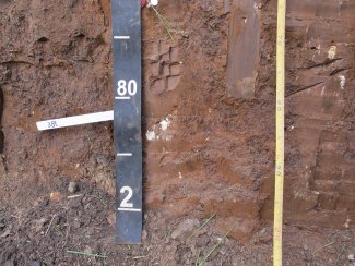
D06 KONZ megapit soil profile 165-200 cm
Megapit Pedon Description
| Print Date | Jul 22 2015 |
|---|---|
| Description Date | Jun 24 2014 |
| Describer | J. Anderson, B. Wehmueller, A. Baldwin, C. Remley |
| Site ID | S2014KS161502 |
| Site Note | This site is the representative soil for the NEON instrumentation located in the Konza Prairie Biological Experiment Station and represents the sites that will have instrumentation installed. |
| Pedon ID | S2014KS161502 |
| Pedon Note | There was weathered limestone being exposed just below 2 meters. This is likely the Schroyer Limestone member of the Wreford Limestone formation in the Chase Group. The lithologic discountinity at 132 cm is based on the chert fragments in the material that appears to be reworked loess. This site is a taxadjunct to Konza since it has a clay decrease and won't meet the "pale" requirements. |
| Lab Source ID | KSSL |
| Lab Pedon # | 14N0855 |
| Soil Name as Described/Sampled | Konza |
| Classification | Fine, smectitic, mesic Pachic Udertic Argiustolls |
| Pedon Type | taxadjunct to the series |
| Pedon Purpose | laboratory sampling site |
| Taxon Kind | series |
| Physiographic Division | Interior Plains |
| Physiographic Province | Central Lowland Province |
| Physiographic Section | Dissected till plains |
| State Physiographic Area | Flint Hills Upland |
| Geomorphic Setting | on shoulder of interfluve of hillslope on upland |
| Upslope Shape | convex |
| Cross Slope Shape | convex |
| Particle Size Control Section | 10 to 60 cm. |
| Description origin | NASIS |
| State | Kansas |
| County | Riley |
| MLRA | 76 -- Bluestem Hills |
| Soil Survey Area | KS161 -- Riley County, Kansas 5-SAL -- Salina, Kansas |
| Map Unit | 4625 -- Dwight-Irwin complex, 1 to 3 percent slopes |
| Quad Name | Swede Creek, Kansas |
| Std Latitude | 39.1007100 |
| Std Longitude | -96.5622500 |
| Latitude | 39 degrees 6 minutes 2.55 seconds north |
| Longitude | 96 degrees 33 minutes 44.10 seconds west |
| Datum | WGS84 |
| UTM Zone | 14 |
| UTM Easting | 710803 meters |
| UTM Northing | 4330782 meters |
| Primary Earth Cover | Grass/herbaceous cover |
| Secondary Earth Cover | Grassland rangeland |
| Parent Material | loess over reworked loess over residuum weathered from cherty limestone |
| Description database | KSSL |
| Diagnostic Features | mollic epipedon 0 to 66 cm. argillic horizon 10 to 132 cm. redox concentrations 66 to 200 cm. lithologic discontinuity 132 to 132 cm. lithologic discontinuity 164 to 164 cm. |
| Slope (%) | 2.0 |
| Elevation (meters) | 417.0 |
| Aspect (deg) | 45 |
| Drainage Class | moderately well |
| Horizon Details |
A--0 to 10 centimeters (0.0 to 3.9 inches); silt loam, very dark grayish brown (10YR 3/2), moist; moderate fine granular structure; friable; very fine roots throughout and fine roots throughout and coarse roots throughout; noneffervescent; abrupt wavy boundary. Lab sample # 14N04350. 3 bulk density clods sampled, no natural fabric clods sampled Bt1--10 to 26 centimeters (3.9 to 10.2 inches); silty clay loam, very dark grayish brown (10YR 3/2), moist; weak medium prismatic parts to moderate medium subangular blocky structure; firm; very fine roots throughout and fine roots throughout; 30 percent 10YR 3/2), moist, clay films on all faces of peds; noneffervescent; clear wavy boundary. Lab sample # 14N04351. 3 bulk density clods sampled, 2 natural fabric clods sampled Bt2--26 to 66 centimeters (10.2 to 26.0 inches); silty clay loam, dark brown (10YR 3/3), moist; weak coarse prismatic parts to moderate medium subangular blocky structure; firm; fine roots throughout and coarse roots throughout; 20 percent 10YR 3/2), moist, clay films on all faces of peds; noneffervescent; clear smooth boundary. Lab sample # 14N04352. 3 bulk density clods sampled, 2 natural fabric clods sampled Btkss--66 to 89 centimeters (26.0 to 35.0 inches); silty clay, dark grayish brown (10YR 4/2), moist; weak coarse prismatic parts to moderate medium subangular blocky structure; very firm; fine roots throughout; 2 percent 10YR 3/3), moist, slickensides (pedogenic) and 20 percent 10YR 3/3), moist, clay films on all faces of peds; 5 percent coarse irregular manganese coatings with sharp boundaries between peds and 10 percent medium irregular 7.5YR 4/4), moist, and 7.5YR 4/6), moist, masses of oxidized iron with diffuse boundaries in matrix; 3 percent fine threadlike carbonate masses with clear boundaries between peds and 2 percent medium irregular weakly cemented carbonate nodules with sharp boundaries between peds; noneffervescent; clear smooth boundary. Lab sample # 14N04353. 3 bulk density clods sampled, 2 natural fabric clods sampled Btky--89 to 132 centimeters (35.0 to 52.0 inches); silty clay loam, grayish brown (10YR 5/2), moist; weak coarse prismatic parts to moderate medium subangular blocky structure; friable; fine roots throughout; 5 percent 10YR 4/1), moist, clay films on surfaces along root channels; 3 percent medium irregular manganese coatings with sharp boundaries between peds and 10 percent coarse irregular 7.5YR 4/6), moist, masses of oxidized iron with clear boundaries in matrix; 5 percent fine threadlike gypsum masses with clear boundaries between peds and 2 percent medium irregular carbonate masses with clear boundaries between peds; noneffervescent; clear wavy boundary. Lab sample # 14N04354. 3 bulk density clods sampled, 2 natural fabric clods sampled 2BCy--132 to 164 centimeters (52.0 to 64.6 inches); silty clay loam, brown (7.5YR 4/3), moist; moderate medium subangular blocky structure; friable; 2 percent gypsum coats on all faces of peds; 5 percent fine irregular manganese coatings with sharp boundaries between peds and 10 percent medium irregular 7.5YR 4/6), moist, and 7.5YR 5/6), moist, masses of oxidized iron with diffuse boundaries in matrix; 3 percent fine threadlike gypsum masses with clear boundaries between peds; 2 percent nonflat rounded indurated 2 to 5-millimeter chert fragments; noneffervescent; clear wavy boundary. Lab sample # 14N04355. 3 bulk density clods sampled, 2 natural fabric clods sampled 3Bt--164 to 200 centimeters (64.6 to 78.7 inches); silty clay, reddish brown (5YR 4/4), moist; moderate coarse prismatic parts to moderate medium subangular blocky structure; very firm; 60 percent 5YR 3/2), moist, clay films on all faces of peds; 10 percent medium irregular manganese coatings with sharp boundaries between peds and 15 percent coarse irregular 7.5YR 4/6), moist, and 7.5YR 5/6), moist, masses of oxidized iron with diffuse boundaries in matrix; 5 percent nonflat rounded indurated 2 to 5-millimeter cherty limestone fragments; noneffervescent. Lab sample # 14N04356. fragments in this horizon are well weathered and rounded, 3 bulk density clods sampled, 2 natural fabric clods sampled |
Credits: This megapit soil pedon description was generously created by USDA Natural Resource Conservation Service staff, with particular thanks to Larry West, Jon Hempel, and numerous field staff.