Konza Prairie Agroecosystem NEON (KONA) Soil Descriptions
Distributed Soils Reports
Pedon Descriptions
Pit‐level observations and field measurements reported using the standard NRCS format. They contain volume estimates for coarse fragments > 20 mm where applicable.
Site Level Plot Summary
A narrative summary that places the sampled soil pedons in the broader context of soils and geomorphology for the entire NEON site.
Megapit Images
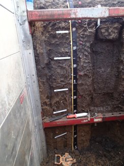
D06 KONA megapit soil profile 5-200 cm
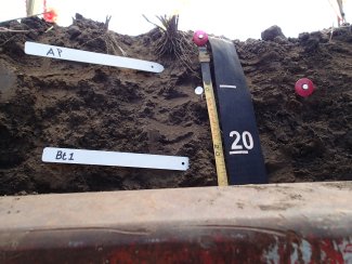
D06 KONA megapit soil profile 0-24 cm
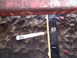
D06 KONA megapit soil profile 29-56 cm
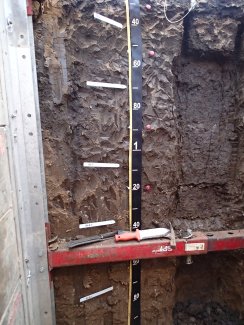
D06 KONA megapit soil profile 29-193 cm
Megapit Pedon Description
| Print Date | Jul 22 2015 |
|---|---|
| Description Date | Aug 4 2014 |
| Describer | D. Kohake, B. Wehmueller, C. Remley, J. Hellerich |
| Site ID | S2015PR055001 |
| Site Note | This site was sampled as a representative soil for the NEON instrumentation located in the Konza Prairie Biological Experiment Station. This site is located in an agricultural field that was currently in wheat stubble. The map unit describes the site as rarely flooded. Most agreed that the site was either rarely or possibly even very rarely flooded. |
| Pedon ID | S2014KS161503 |
| Pedon Note | This pedon description was classified as a Pachic Vertic Argiudoll which is a taxadjunct to the Chase series. It was felt that this Chase pedon would not have aquic conditions. It was also felt that it would not meet the requirements of oxyaquic (saturation for 20 or more consecutive days or 30 or more cumulative days) during normal years. The organoargillans that were described in the lower horizons were along old large root channels that were from before this field was farmed. |
| Lab Source ID | KSSL |
| Lab Pedon # | 14N0950 |
| Soil Name as Described/Sampled | Chase |
| Classification | Fine, smectitic, mesic Pachic Vertic Argiudolls |
| Pedon Type | taxadjunct to the series |
| Pedon Purpose | laboratory sampling site |
| Taxon Kind | taxadjunct |
| Physiographic Division | Interior Plains |
| Physiographic Province | Central Lowland Province |
| Physiographic Section | Dissected till plains |
| State Physiographic Area | Flint Hills Upland |
| Geomorphic Setting | on tread of terrace on river valley |
| Upslope Shape | linear |
| Cross Slope Shape | linear |
| Particle Size Control Section | 12 to 62 cm. |
| Description origin | NASIS |
| Country | United States |
| State | Kansas |
| County | Riley |
| MLRA | 76 -- Bluestem Hills |
| Soil Survey Area | KS161 -- Riley County, Kansas 5-SAL -- Salina, Kansas |
| Map Unit | 4350 -- Chase silty clay loam, rarely flooded |
| Quad Name | Swede Creek, Kansas |
| Std Latitude | 39.1082778 |
| Std Longitude | -96.6104722 |
| Latitude | 39 degrees 6 minutes 29.80 seconds north |
| Longitude | 96 degrees 36 minutes 37.70 seconds west |
| Datum | WGS84 |
| UTM Zone | 14 |
| UTM Easting | 706610 meters |
| UTM Northing | 4331511 meters |
| Primary Earth Cover | Crop cover |
| Secondary Earth Cover | Close-grown crop |
| Parent Material | Close-grown crop |
| Description database | KSSL |
| Diagnostic Features | mollic epipedon 0 to 119 cm. argillic horizon 12 to 200 cm. redox concentrations 31 to 119 cm. slickensides 89 to 156 cm. secondary carbonates 119 to 200 cm. |
| Slope (%) | 1.0 |
| Elevation (meters) | 328.0 |
| Aspect (deg) | 45 |
| Drainage Class | moderately well |
| Horizon Details |
Ap--0 to 12 centimeters (0.0 to 4.7 inches); very dark brown (10YR 2/2) silty clay loam, dark grayish brown (10YR 4/2), dry; 5 percent sand; 30 percent clay; weak coarse cloddy structure; slightly hard, friable; common fine roots throughout; noneffervescent; abrupt smooth boundary. Lab sample # 14N04703 Bt1--12 to 31 centimeters (4.7 to 12.2 inches); very dark brown (10YR 2/2) silty clay loam, dark grayish brown (10YR 4/2), dry; 5 percent sand; 36 percent clay; moderate fine subangular blocky structure; moderately hard, friable; common fine roots throughout; 20 percent faint 10YR 2/2), moist, clay films on all faces of peds; noneffervescent; clear smooth boundary. Lab sample # 14N04704 Bt2--31 to 54 centimeters (12.2 to 21.3 inches); very dark brown (10YR 2/2) silty clay, dark grayish brown (10YR 4/2), dry; 5 percent sand; 46 percent clay; weak medium prismatic parts to moderate medium subangular blocky structure; moderately hard, firm; common fine roots throughout; 25 percent faint 10YR 2/2), moist, clay films on all faces of peds; 1 percent fine distinct 7.5YR 4/4), moist, masses of oxidized iron; noneffervescent; gradual smooth boundary. Lab sample # 14N04705 Bt3--54 to 89 centimeters (21.3 to 35.0 inches); very dark grayish brown (10YR 3/2) silty clay, grayish brown (10YR 5/2), dry; 5 percent sand; 44 percent clay; weak medium prismatic parts to moderate medium subangular blocky structure; moderately hard, firm; common fine roots throughout; 30 percent faint 10YR 3/2), moist, clay films on all faces of peds; 2 percent fine distinct 7.5YR 5/6), moist, masses of oxidized iron; noneffervescent; gradual smooth boundary. Lab sample # 14N04706 Btss--89 to 119 centimeters (35.0 to 46.9 inches); dark brown (10YR 3/3) silty clay, brown (10YR 5/3), dry; 5 percent sand; 42 percent clay; moderate coarse prismatic parts to moderate medium subangular blocky structure; moderately hard, firm; few fine roots throughout; 1 percent prominent 10YR 2/1), moist, organoargillans on surfaces along root channels and 10 percent distinct slickensides (pedogenic) and 30 percent distinct 10YR 3/2), moist, clay films on all faces of peds; 1 percent fine distinct 7.5YR 5/6), moist, masses of oxidized iron; noneffervescent; clear smooth boundary. Lab sample # 14N04707 Btkss--119 to 156 centimeters (46.9 to 61.4 inches); brown (10YR 4/3) silty clay loam, pale brown (10YR 6/3), dry; 5 percent sand; 38 percent clay; moderate coarse prismatic parts to moderate medium subangular blocky structure; moderately hard, firm; 1 percent prominent 10YR 2/1), moist, organoargillans on surfaces along root channels and 10 percent distinct slickensides (pedogenic) and 30 percent distinct 10YR 3/2), moist, clay films on all faces of peds; 2 percent coarse moderately cemented 10YR 6/2), moist, carbonate concretions; noneffervescent; gradual smooth boundary. Lab sample # 14N04708 Btk--156 to 200 centimeters (61.4 to 78.7 inches); brown (10YR 4/3) silty clay loam, pale brown (10YR 6/3), dry; 5 percent sand; 35 percent clay; moderate coarse prismatic parts to moderate medium subangular blocky structure; slightly hard, firm; 2 percent prominent 10YR 2/1), moist, organoargillans on surfaces along root channels and 20 percent distinct 10YR 3/3), moist, clay films on all faces of peds; 1 percent medium weakly cemented carbonate concretions and 2 percent medium threadlike carbonate masses; noneffervescent. Lab sample # 14N04709 |
Credits: This megapit soil pedon description was generously created by USDA Natural Resource Conservation Service staff, with particular thanks to Larry West, Jon Hempel, and numerous field staff.