Jornada Experimental Range NEON (JORN) Soil Descriptions
Distributed Soils Reports
Pedon Descriptions
Pit‐level observations and field measurements reported using the standard NRCS format. They contain volume estimates for coarse fragments > 20 mm where applicable.
Site Level Plot Summary
A narrative summary that places the sampled soil pedons in the broader context of soils and geomorphology for the entire NEON site.
Megapit Images
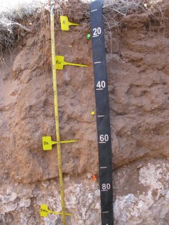
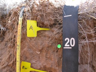
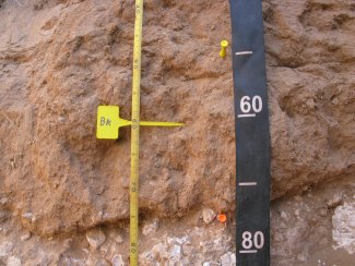
D14 JORN megapit soil profile 0-98 cm
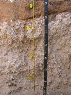
D14 JORN megapit soil profile 52-200 cm
D14 JORN megapit soil profile 0-28 cm
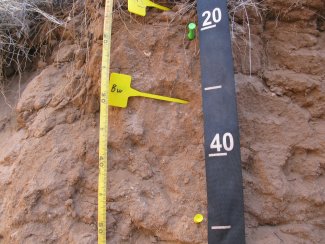
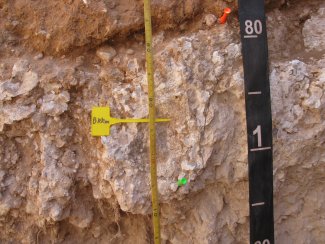
D14 JORN megapit soil profile 13-52 cm
D14 JORN megapit soil profile 39-83 cm
D14 JORN megapit soil profile 72-106 cm
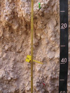
D14 JORN megapit soil profile 100-159 cm
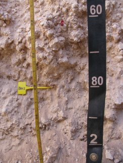
D14 JORN megapit soil profile 154-200 cm
Megapit Pedon Description
| Print Date | Jul 22 2015 |
|---|---|
| Description Date | Mar 5 2013 |
| Describer | Dave White |
| Site ID | S2013NM0135000 |
| Pedon ID | S2013NM013001 |
| Lab Source ID | SSL |
| Lab Pedon # | 13N8337 |
| Soil Name as Described/Sampled | Nations |
| Classification | Coarse-loamy, mixed, superactive, thermic Typic Petrocalcids |
| Pedon Type | undefined observation |
| Pedon Purpose | research site |
| Taxon Kind | series |
| Associated Soils | Copia, Onite, Pintura, Wink |
| Physiographic Division | Intermontane Plateaus |
| Physiographic Province | Basin and Range Province |
| Physiographic Section | Mexican Highland/td> |
| Local Physiographic Area | Jornada Del Muerto |
| Geomorphic Setting | on backslope of tread of fan remnant on fan piedmont |
| Upslope Shape | linear |
| Cross Slope Shape | concave |
| Particle Size Control Section | 25 to 78 cm. |
| Description origin | NASIS |
| Country | United States |
| State | New Mexico |
| County | Doña Ana |
| MLRA | 42 -- Southern Desertic Basins, Plains, and Mountains |
| Soil Survey Area | NM690 -- Dona Ana County Area, New Mexico 8-LAS -- Las Cruces, New Mexico |
| Map Unit | WP -- Wink-Pintura complex |
| Quad Name | Summerford Mountain, New Mexico |
| Std Latitude | 32.5905194 |
| Std Longitude | -106.8437722 |
| Latitude | 32 degrees 35 minutes 25.87 seconds north |
| Longitude | 106 degrees 50 minutes 37.58 seconds west |
| Datum | NAD83 |
| UTM Zone | 13 |
| UTM Easting | 326959 meters |
| UTM Northing | 3607393 meters |
| Primary Earth Cover | Grass/herbaceous cover |
| Secondary Earth Cover | Grassland rangeland |
| Existing Vegetation | alkali sacaton, black grama, desert zinnia, honey mesquite, longleaf jointfir, mesa dropseed, soaptree yucca |
| Parent Material | sandy eolian deposits over alluvium |
| Surface Fragments | 1.0 percent nonflat subrounded indurated 2- to 75-millimeter mixed rock fragments |
| Description database | KSSL |
| Diagnostic Features | ochric epipedon 0 to 18 cm. cambic horizon 18 to 78 cm. petrocalcic horizon 78 to 110 cm. calcic horizon 78 to 200 cm. |
| Top Depth (cm) | 78 |
| Bottom Depth (cm) | 110 |
| Restriction Kind | petrocalcic |
| Restriction Hardness | indurated |
| Slope (%) | 2.0 |
| Elevation (meters) | 1,327.0 |
| Aspect (deg) | 55 |
| MAAT (C) | 16.0 |
| MAP (mm) | 193 |
| Frost-Free Days | 210 |
| Drainage Class | moderately well |
| Slope Length (meters) | 152 |
| Horizon Details |
A--0 to 18 centimeters (0.0 to 7.1 inches); brown (7.5YR 5/4) crushed sandy loam, brown (7.5YR 4/4) crushed, moist; 65 percent sand; 25 percent silt; 10 percent clay; weak thick platy parts to weak medium subangular blocky, and weak thick platy parts to moderate fine subangular blocky structure; soft, very friable, slightly sticky, nonplastic; low excavation difficulty; common very fine roots throughout and common medium roots throughout and many fine roots throughout; common very fine irregular and common very fine tubular pores; noneffervescent, by HCl, 1 normal; neutral, pH 7.1, pH meter; clear smooth boundary. Lab sample # 13N03593 Bw--18 to 46 centimeters (7.1 to 18.1 inches); strong brown (7.5YR 5/6) crushed sandy loam, strong brown (7.5YR 4/6) crushed, moist; 65 percent sand; 27 percent silt; 8 percent clay; weak medium subangular blocky parts to moderate fine subangular blocky structure; soft, very friable, slightly sticky, nonplastic; low excavation difficulty; common very fine roots throughout; common very fine irregular and common fine tubular pores; carbonate, finely disseminated throughout; slight effervescence, by HCl, 1 normal; slightly alkaline, pH 7.7, pH meter; gradual smooth boundary. Lab sample # 13N03594 2Bk--46 to 78 centimeters (18.1 to 30.7 inches); strong brown (7.5YR 5/6) crushed and strong brown (7.5YR 4/6) crushed sandy clay loam; 70 percent sand; 8 percent silt; 22 percent clay; moderate medium subangular blocky structure; slightly hard, friable, moderately sticky, slightly plastic; moderate excavation difficulty; common very fine roots throughout and few medium roots throughout; common very fine irregular and common very fine tubular pores; carbonate, finely disseminated throughout and 10 percent fine prominent threadlike 7.5YR 9.5/1), dry, carbonate masses with clear boundaries lining pores; 1 percent nonflat subrounded indurated 2 to 75-millimeter mixed rock fragments; strong effervescence, by HCl, 1 normal; slightly alkaline, pH 7.8, pH meter; abrupt smooth boundary. Lab sample # 13N03595 2Bkkm--78 to 110 centimeters (30.7 to 43.3 inches); white (7.5YR 9.5/1) broken face cemented material, pale pinkish white (7.5YR 9/2) broken face, moist; indurated by carbonates; very high excavation difficulty; common very fine roots in cracks and common medium roots in cracks; 90 percent prominent 7.5YR 9.5/1), dry, carbonate coats on rock fragments; carbonate, finely disseminated throughout and 70 percent extremely coarse prominent irregular indurated cemented 7.5YR 9.5/1), dry, carbonate nodules with sharp boundaries in matrix; 6 percent nonflat subrounded indurated 2 to 75-millimeter mixed rock fragments; violent effervescence, by HCl, 1 normal; moderately alkaline, pH 7.9, pH meter; clear smooth boundary. Lab sample # 13N03596 2Bkk1--110 to 173 centimeters (43.3 to 68.1 inches); white (7.5YR 9.5/1) broken face sandy loam, pale pinkish white (7.5YR 9/2) broken face, moist; 60 percent sand; 34 percent silt; 6 percent clay; moderate medium subangular blocky, and weak fine subangular blocky structure; extremely hard, very rigid, slightly sticky, nonplastic; high excavation difficulty; many very fine roots throughout and common medium roots throughout and many fine roots throughout and common coarse roots throughout; many very fine irregular pores; 90 percent prominent 7.5YR 9.5/1), dry, carbonate coats on rock fragments; 50 percent extremely coarse prominent irregular indurated cemented 7.5YR 9.5/1), dry, carbonate nodules with sharp boundaries in matrix; 2 percent nonflat subrounded indurated 2 to 75-millimeter mixed rock fragments; violent effervescence, by HCl, 1 normal; moderately alkaline, pH 7.9, pH meter; gradual smooth boundary. Lab sample # 13N03597 2Bkk2--173 to 200 centimeters (68.1 to 78.7 inches); white (7.5YR 9/1) broken face sandy loam, pale pinkish white (7.5YR 9/2) broken face, moist; 65 percent sand; 27 percent silt; 8 percent clay; moderate medium subangular blocky, and weak fine subangular blocky structure; extremely hard, very rigid, slightly sticky, nonplastic; high excavation difficulty; many very fine roots throughout and common fine roots throughout; many very fine irregular pores; 90 percent prominent carbonate coats on rock fragments; carbonate, finely disseminated throughout and 35 percent extremely coarse prominent irregular indurated cemented 7.5YR 9/1), dry, carbonate nodules with sharp boundaries in matrix; 1 percent nonflat subrounded indurated 2 to 75-millimeter mixed rock fragments; violent effervescence, by HCl, 1 normal; slightly alkaline, pH 7.7, pH meter. Lab sample # 13N03598 |
Credits: This megapit soil pedon description was generously created by USDA Natural Resource Conservation Service staff, with particular thanks to Larry West, Jon Hempel, and numerous field staff.