NSF NEON, Operated by Battelle

Main navigation

  • About
    • NEON Overview
      • Vision and Management
      • Spatial and Temporal Design
      • History
    • About the NEON Biorepository
      • ASU Biorepository Staff
      • Contact the NEON Biorepository
    • Observatory Blog
    • Newsletters
    • Staff
    • FAQ
    • Contact Us

    About

  • Data
    • Data Portal
      • Data Availability Charts
      • API & GraphQL
      • Prototype Data
      • Externally Hosted Data
    • Data Collection Methods
      • Airborne Observation Platform (AOP)
      • Instrument System (IS)
        • Instrumented Collection Types
        • Aquatic Instrument System (AIS)
        • Terrestrial Instrument System (TIS)
      • Observational System (OS)
        • Observation Types
        • Observational Sampling Design
        • Sampling Schedules
        • Taxonomic Lists Used by Field Staff
        • Optimizing the Observational Sampling Designs
      • Protocols & Standardized Methods
    • Getting Started with NEON Data
      • neonUtilities for R and Python
      • Learning Hub
      • Code Hub
    • Using Data
      • Data Formats and Conventions
      • Released, Provisional, and Revised Data
      • Data Product Bundles
      • Usage Policies
      • Acknowledging and Citing NEON
      • Publishing Research Outputs
    • Data Notifications
    • NEON Data Management
      • Data Availability
      • Data Processing
      • Data Quality

    Data

  • Samples & Specimens
    • Biorepository Sample Portal at ASU
    • About Samples
      • Sample Types
      • Sample Repositories
      • Megapit and Distributed Initial Characterization Soil Archives
    • Finding and Accessing Sample Data
      • Species Checklists
      • Sample Explorer - Relationships and Data
      • Biorepository API
    • Requesting and Using Samples
      • Loans & Archival Requests
      • Usage Policies

    Samples & Specimens

  • Field Sites
    • Field Site Map and Info
    • Spatial Layers & Printable Maps

    Field Sites

  • Resources
    • Getting Started with NEON Data
    • Research Support Services
      • Field Site Coordination
      • Letters of Support
      • Mobile Deployment Platforms
      • Permits and Permissions
      • AOP Flight Campaigns
      • Research Support FAQs
      • Research Support Projects
    • Code Hub
      • neonUtilities for R and Python
      • Code Resources Guidelines
      • Code Resources Submission
      • NEON's GitHub Organization Homepage
    • Learning Hub
      • Tutorials
      • Workshops & Courses
      • Science Videos
      • Teaching Modules
    • Science Seminars and Data Skills Webinars
    • Document Library
    • Funding Opportunities

    Resources

  • Impact
    • Research Highlights
    • Papers & Publications
    • NEON in the News

    Impact

  • Get Involved
    • Upcoming Events
    • Research and Collaborations
      • Environmental Data Science Innovation and Inclusion Lab
      • Collaboration with DOE BER User Facilities and Programs
      • EFI-NEON Ecological Forecasting Challenge
      • NEON Great Lakes User Group
      • NCAR-NEON-Community Collaborations
    • Advisory Groups
      • Science, Technology & Education Advisory Committee
      • Technical Working Groups
    • NEON Ambassador Program
      • Exploring NEON-Derived Data Products Workshop Series
    • Partnerships
    • Community Engagement
    • Work Opportunities

    Get Involved

  • My Account
  • Search

Search

Breadcrumb

  1. Data Collection Methods
  2. Soils
  3. Soil Descriptions
  4. The Jones Center At Ichauway NEON (JERC) Soil Descriptions

The Jones Center At Ichauway NEON (JERC) Soil Descriptions

Distributed Soils Reports

Pedon Descriptions

Pit‐level observations and field measurements reported using the standard NRCS format. They contain volume estimates for coarse fragments > 20 mm where applicable.

Download

Site Level Plot Summary

A narrative summary that places the sampled soil pedons in the broader context of soils and geomorphology for the entire NEON site.

Download

Megapit Images

soil profile

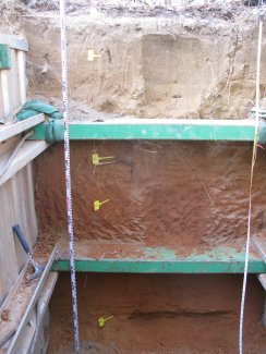
D03 JERC megapit soil profile 0-200 cm

soil profile

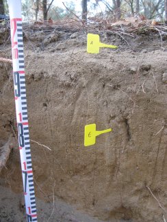
D03 JERC megapit soil profile 0-41 cm

soil profile

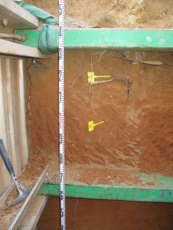
D03 JERC megapit soil profile 48-162 cm

soil profile

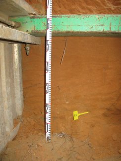
D03 JERC megapit soil profile 132-200 cm

Download All Images

Megapit Pedon Description

Print Date Jul 22 2015
Description Date Dec 10 2012
Describer Ken Monroe
Site ID S2012GA007002
Pedon ID S2012GA007002
Lab Source ID KSSL
Lab Pedon # 13N0259
Soil Name as Described/Sampled Lucy
Classification Loamy, kaolinitic, thermic Arenic Kandiudults
Pedon Type representative pedon for component
Pedon Purpose research site
Taxon Kind series
Associated Soils Norfork, Orangeburg, Troup, Wagram
Geomorphic Setting on summit of interfluve of ridge on upland on coastal plain coastal plain
Upslope Shape convex
Cross Slope Shape convex
Particle Size Control Section 68 to 118 cm.
Description origin NASIS
State Georgia
County Baker
MLRA 133A -- Southern Coastal Plain
Soil Survey Area GA603 -- Baker and Mitchell Counties, Georgia
7-TIF -- Tifton, Georgia
Map Unit TwB -- Troup sand, 0 to 5 percent slopes
Quad Name Hopeful, Georgia
Std Latitude 31.1960694
Std Longitude -84.4664694
Latitude 31 degrees 11 minutes 45.85 seconds north
Longitude 84 degrees 27 minutes 59.29 seconds west
Datum NAD83
UTM Zone 16
UTM Easting 741407 meters
UTM Northing 3454097 meters
Primary Earth Cover Grass/herbaceous cover
Secondary Earth Cover Intermixed conifers and hardwoods
Existing Vegetation broomsedge bluestem, longleaf pine, turkey oak, wiregrass gentian
Parent Material loamy marine deposits and/or sandy marine deposits
Description database KSSL
Diagnostic Features ochric epipedon 0 to 68 cm.
kandic horizon 68 to 203 cm.
argillic horizon 68 to 203 cm.
Slope (%) 2.0
Elevation (meters) 45.7
Aspect (deg) 90
MAAT (C) 27.2
MWAT (C) 11.1
MAP (mm) 1,312
Drainage Class well
Horizon Details

A--0 to 8 centimeters (0.0 to 3.1 inches); grayish brown (10YR 5/2) sand; weak fine granular structure; loose, very friable; very fine roots and fine roots; abrupt smooth boundary. Lab sample # 13N00561

E--8 to 68 centimeters (3.1 to 26.8 inches); yellowish brown (10YR 5/4) oxidized sand; single grain; loose, loose; medium roots and fine roots; clear smooth boundary. Lab sample # 13N00562

Bt1--68 to 105 centimeters (26.8 to 41.3 inches); brown (7.5YR 4/4) oxidized sandy loam; weak medium subangular blocky parts to weak fine subangular blocky structure; slightly hard, friable; medium roots and coarse roots; gradual wavy boundary. Lab sample # 13N00563

Bt2--105 to 185 centimeters (41.3 to 72.8 inches); yellowish red (5YR 4/6) oxidized sandy clay loam; weak medium subangular blocky structure; slightly hard, friable; medium roots; gradual wavy boundary. Lab sample # 13N00564

Bt3--185 to 203 centimeters (72.8 to 79.9 inches); reddish brown (5YR 5/4) oxidized sandy loam; weak fine subangular blocky structure; slightly hard, friable; . Lab sample # 13N00565

Credits: This megapit soil pedon description was generously created by USDA Natural Resource Conservation Service staff, with particular thanks to Larry West, Jon Hempel, and numerous field staff.

NSF NEON, Operated by Battelle

Follow Us:

Join Our Newsletter

Get updates on events, opportunities, and how NEON is being used today.

Subscribe Now

Footer

  • About Us
  • Contact Us
  • Terms & Conditions
  • Careers
  • Code of Conduct

Copyright © Battelle, 2026

The National Ecological Observatory Network is a major facility fully funded by the U.S. National Science Foundation.

Any opinions, findings and conclusions or recommendations expressed in this material do not necessarily reflect the views of the U.S. National Science Foundation.