Disney Wilderness Preserve NEON (DSNY) Soil Descriptions
Distributed Soils Reports
Pedon Descriptions
Pit‐level observations and field measurements reported using the standard NRCS format. They contain volume estimates for coarse fragments > 20 mm where applicable.
Site Level Plot Summary
A narrative summary that places the sampled soil pedons in the broader context of soils and geomorphology for the entire NEON site.
Megapit Images
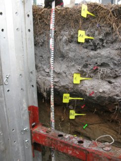
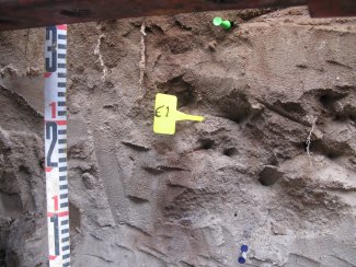
D03 DSNY megapit soil profile 0-65 cm
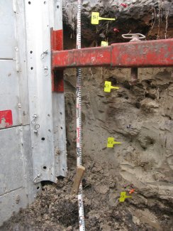
D03 DSNY megapit soil profile 39-140 cm
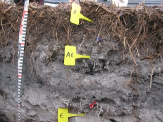
D03 DSNY megapit soil profile 0-35 cm
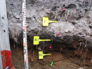
D03 DSNY megapit soil profile 24-65 cm
D03 DSNY megapit soil profile 70-96 cm
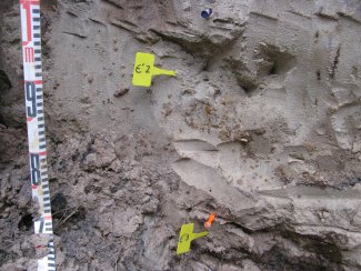
D03 DSNY megapit soil profile 100-135 cm
Megapit Pedon Description
| Print Date | Apr 8 2015 |
|---|---|
| Description Date | Feb 4 2013 |
| Describer | R. Robbins |
| Site ID | 13FL097001 |
| Site Note | This pedon is within the range of the Smyrna series. The Bh horizon begins at 43 centimeters. It has a bisequum with a E' and B'h horizons beginning at 69 centimeters. |
| Pedon ID | S2013FL097001 |
| Pedon Note | pH was not performed since this pedon will be analyzed in the lab. |
| Lab Source ID | SSL |
| Lab Pedon # | 13N0610 |
| Soil Name as Described/Sampled | Smyrna |
| Classification | Sandy, siliceous, hyperthermic Aeric Alaquods |
| Soil Name as Correlated | Smyrna |
| Pedon Type | correlates to named soil |
| Pedon Purpose | research site |
| Taxon Kind | series |
| Associated Soils | Basinger fine sand, depressional, Immokalee fine sand, Myakka fine sand |
| Geomorphic Setting | on toeslope of talf flatwoods on marine terrace on coastal plain |
| Upslope Shape | linear |
| Cross Slope Shape | linear |
| Particle Size Control Section | 25 to 100 cm. |
| Description origin | NASIS |
| Map Unit | 42 -- Smyrna fine sand, 0 to 2 percent slopes |
| Quad Name | Lake Hatchineha, Florida |
| Std Latitude | 28.1291889 |
| Std Longitude | -81.4339194 |
| Latitude | 28 degrees 7 minutes 45.08 seconds north |
| Longitude | 81 degrees 26 minutes 2.11 seconds west |
| Datum | NAD83 |
| UTM Zone | 17 |
| Primary Earth Cover | Grass/herbaceous cover |
| Parent Material | sandy marine deposits |
| Description database | KSSL |
| Diagnostic Features | spodic horizon 43 to 69 cm. spodic horizon 152 to 204 cm. |
| Slope (%) | 0.0 |
| Elevation (meters) | 20.1 |
| MAAT (C) | 22.7 |
| MAP (mm) | 1,186 |
| Frost-Free Days | 345 |
| Drainage Class | poorly |
| Slope Length (meters) | 47 |
| Horizon Details |
Ap--0 to 9 centimeters (0.0 to 3.5 inches); very dark gray (10YR 3/1) interior fine sand, dark gray (10YR 4/1) interior, dry; 92 percent sand; 5 percent silt; 3 percent clay; weak fine granular, and weak very fine granular structure; very friable, nonsticky, nonplastic; low excavation difficulty; common medium roots throughout and many fine roots throughout; clear smooth boundary. Lab sample # 13N02896. Uncoated sand grains (10YR 7/1) comprise about 5% of the individual sand grains. AE--9 to 26 centimeters (3.5 to 10.2 inches); dark gray (10YR 4/1) interior fine sand; 95 percent sand; 3 percent silt; 2 percent clay; weak medium subangular blocky, and weak coarse subangular blocky structure; very friable, nonsticky, nonplastic; low excavation difficulty; common medium roots throughout and many fine roots throughout; gradual wavy boundary. Lab sample # 13N02897. Uncoated sand grains (10YR 7/1) comprise about 25% of the individual sand grains. E--26 to 43 centimeters (10.2 to 16.9 inches); gray (10YR 5/1) interior fine sand; 96 percent sand; 2 percent silt; 2 percent clay; structureless single grain; loose, nonsticky, nonplastic; low excavation difficulty; common medium roots throughout and common fine roots throughout; 3 percent faint 10YR 4/2), moist, organic stains on surfaces along root channels; abrupt wavy boundary. Lab sample # 13N02898 Bh1--43 to 55 centimeters (16.9 to 21.7 inches); black (10YR 2/1) interior fine sand; 93 percent sand; 3 percent silt; 4 percent clay; weak fine subangular blocky, and weak medium subangular blocky structure; very friable, slightly sticky, nonplastic; low excavation difficulty; common medium roots throughout and common fine roots throughout; gradual wavy boundary. Lab sample # 13N02899 Bh2--55 to 69 centimeters (21.7 to 27.2 inches); 80 percent dark reddish brown (5YR 3/4) interior and 20 percent dark brown (7.5YR 3/2) interior fine sand; 94 percent sand; 3 percent silt; 3 percent clay; weak medium subangular blocky, and weak coarse subangular blocky structure; very friable, slightly sticky, nonplastic; low excavation difficulty; common medium roots throughout and common fine roots throughout; and 4 percent distinct 7.5YR 2.5/1), moist, organic stains on surfaces along root channels; clear wavy boundary. Lab sample # 13N02900. 5% pale brown (10YR 6/3) uncoated sand grains E'1--69 to 99 centimeters (27.2 to 39.0 inches); brown (10YR 5/3) interior fine sand; 96 percent sand; 2 percent silt; 2 percent clay; structureless single grain; loose, nonsticky, nonplastic; low excavation difficulty; common medium roots throughout and common fine roots throughout; 5 percent distinct 7.5YR 3/3), moist, organic stains on surfaces along root channels; 10 percent medium faint 10YR 7/2), moist, iron depletions with diffuse boundaries in matrix; 2 percent nonflat rounded moderately cemented 10 to 30-millimeter iron-manganese nodules; gradual wavy boundary. Lab sample # 13N02901 E'2--99 to 136 centimeters (39.0 to 53.5 inches); light brownish gray (10YR 6/2) interior fine sand; 96 percent sand; 2 percent silt; 2 percent clay; structureless single grain; loose, nonsticky, nonplastic; low excavation difficulty; common fine roots throughout; 2 percent distinct 7.5YR 3/3), moist, organic stains on surfaces along root channels; and 2 percent fine distinct irregular 7.5YR 4/4), moist, iron-manganese masses with sharp boundaries in matrix and 10 percent medium faint irregular 10YR 7/2), moist, iron depletions with diffuse boundaries in matrix; 1 percent nonflat rounded moderately cemented 10 to 30-millimeter iron-manganese nodules; gradual wavy boundary. Lab sample # 13N02902 E'3--136 to 152 centimeters (53.5 to 59.8 inches); brown (10YR 5/3) interior fine sand; 96 percent sand; 2 percent silt; 2 percent clay; structureless single grain; loose, nonsticky, nonplastic; low excavation difficulty; 2 percent fine distinct irregular 7.5YR 5/6), moist, iron-manganese masses with sharp boundaries in matrix and 5 percent medium faint irregular 10YR 6/2), moist, iron depletions in matrix; abrupt wavy boundary. B'h--152 to 204 centimeters (59.8 to 80.3 inches); very dark brown (7.5YR 2.5/2) interior fine sand; 91 percent sand; 5 percent silt; 4 percent clay; weak medium subangular blocky structure; very friable, slightly sticky, nonplastic; low excavation difficulty; 2 percent fine distinct irregular 7.5YR 5/6), moist, iron-manganese masses with sharp boundaries in matrix. Lab sample # 13N02904. Horizon color grades from 7.5YR 2.5/2 to 10YR 3/2. With saturation, it is difficult to obtain a correct depth measurement. |
Credits: This megapit soil pedon description was generously created by USDA Natural Resource Conservation Service staff, with particular thanks to Larry West, Jon Hempel, and numerous field staff.