NSF NEON, Operated by Battelle

Main navigation

  • About Us
    • Overview
      • Spatial and Temporal Design
      • History
    • Vision and Management
    • Advisory Groups
      • Science, Technology & Education Advisory Committee
      • Technical Working Groups (TWGs)
    • FAQ
    • Contact Us
      • Contact NEON Biorepository
      • Field Offices
    • User Accounts
    • Staff
    • Code of Conduct

    About Us

  • Data & Samples
    • Data Portal
      • Explore Data Products
      • Data Availability Charts
      • Spatial Data & Maps
      • Document Library
      • API & GraphQL
      • Prototype Data
      • External Lab Data Ingest (restricted)
    • Data Themes
      • Biogeochemistry
      • Ecohydrology
      • Land Cover and Processes
      • Organisms, Populations, and Communities
    • Samples & Specimens
      • Discover and Use NEON Samples
        • Sample Types
        • Sample Repositories
        • Sample Explorer
        • Megapit and Distributed Initial Characterization Soil Archives
      • Sample Processing
      • Sample Quality
      • Taxonomic Lists
    • Collection Methods
      • Protocols & Standardized Methods
      • Airborne Remote Sensing
        • Flight Box Design
        • Flight Schedules and Coverage
        • Daily Flight Reports
          • AOP Flight Report Sign Up
        • Camera
        • Imaging Spectrometer
        • Lidar
      • Automated Instruments
        • Site Level Sampling Design
        • Sensor Collection Frequency
        • Instrumented Collection Types
          • Meteorology
          • Phenocams
          • Soil Sensors
          • Ground Water
          • Surface Water
      • Observational Sampling
        • Site Level Sampling Design
        • Sampling Schedules
        • Observation Types
          • Aquatic Organisms
            • Aquatic Microbes
            • Fish
            • Macroinvertebrates & Zooplankton
            • Periphyton, Phytoplankton, and Aquatic Plants
          • Terrestrial Organisms
            • Birds
            • Ground Beetles
            • Mosquitoes
            • Small Mammals
            • Soil Microbes
            • Terrestrial Plants
            • Ticks
          • Hydrology & Geomorphology
            • Discharge
            • Geomorphology
          • Biogeochemistry
          • DNA Sequences
          • Pathogens
          • Sediments
          • Soils
            • Soil Descriptions
        • Optimizing the Observational Sampling Designs
    • Data Notifications
    • Data Guidelines and Policies
      • Acknowledging and Citing NEON
      • Publishing Research Outputs
      • Usage Policies
    • Data Management
      • Data Availability
      • Data Formats and Conventions
      • Data Processing
      • Data Quality
      • Data Product Bundles
      • Data Product Revisions and Releases
        • Release 2021
        • Release 2022
        • Release 2023
        • Release 2024
        • Release-2025
      • NEON and Google
      • Externally Hosted Data

    Data & Samples

  • Field Sites
    • About Field Sites and Domains
    • Explore Field Sites
    • Site Management Data Product

    Field Sites

  • Impact
    • Observatory Blog
    • Case Studies
    • Papers & Publications
    • Newsroom
      • NEON in the News
      • Newsletter Archive
      • Newsletter Sign Up

    Impact

  • Resources
    • Getting Started with NEON Data & Resources
    • Documents and Communication Resources
      • Papers & Publications
      • Document Library
      • Outreach Materials
    • Code Hub
      • Code Resources Guidelines
      • Code Resources Submission
      • NEON's GitHub Organization Homepage
    • Learning Hub
      • Science Videos
      • Tutorials
      • Workshops & Courses
      • Teaching Modules
    • Research Support Services
      • Field Site Coordination
      • Letters of Support
      • Mobile Deployment Platforms
      • Permits and Permissions
      • AOP Flight Campaigns
      • Research Support FAQs
      • Research Support Projects
    • Funding Opportunities

    Resources

  • Get Involved
    • Advisory Groups
      • Science, Technology & Education Advisory Committee
      • Technical Working Groups
    • Upcoming Events
    • NEON Ambassador Program
      • Exploring NEON-Derived Data Products Workshop Series
    • Research and Collaborations
      • Environmental Data Science Innovation and Inclusion Lab
      • Collaboration with DOE BER User Facilities and Programs
      • EFI-NEON Ecological Forecasting Challenge
      • NEON Great Lakes User Group
      • NEON Science Summit
      • NCAR-NEON-Community Collaborations
        • NCAR-NEON Community Steering Committee
    • Community Engagement
      • How Community Feedback Impacts NEON Operations
    • Science Seminars and Data Skills Webinars
      • Past Years
    • Work Opportunities
      • Careers
      • Seasonal Fieldwork
      • Internships
        • Intern Alumni
    • Partners

    Get Involved

  • My Account
  • Search

Search

Breadcrumb

  1. Data Collection Methods
  2. Soils
  3. Soil Descriptions
  4. Dead Lake NEON (DELA) Soil Descriptions

Dead Lake NEON (DELA) Soil Descriptions

Distributed Soils Reports

Pedon Descriptions

Pit‐level observations and field measurements reported using the standard NRCS format. They contain volume estimates for coarse fragments > 20 mm where applicable.

Download

Site Level Plot Summary

A narrative summary that places the sampled soil pedons in the broader context of soils and geomorphology for the entire NEON site.

Download

Megapit Images

soil profile

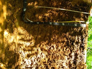
D08 DELA megapit soil profile 0-100 cm

soil profile

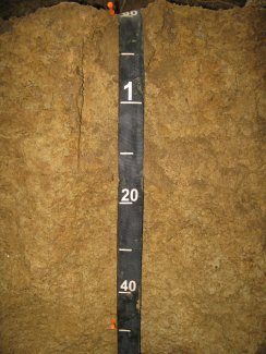
D08 DELA megapit soil profile 80-155 cm

soil profile

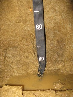
D08 DELA megapit soil profile 145-191 cm

Download All Images

Megapit Pedon Description

Print Date Jul 22 2015
Description Date Apr 29 2013
Describer Lawrence McGhee
Site ID S2013AL063001
Pedon ID S2013AL063001
Lab Source ID SSL
Lab Pedon # 13N49390
Soil Name as Described/Sampled Angie
Classification Fine, mixed, semiactive, thermic Aquic Paleudults
Pedon Type confirmation description
Pedon Purpose research site
Taxon Kind series
Geomorphic Setting microhigh on toeslope of tread of flood plain
Upslope Shape linear
Cross Slope Shape linear
Particle Size Control Section 27 to 77 cm.
Description origin NASIS
Country United States
State Alabama
County Greene
MLRA 133A -- Southern Coastal Plain
Soil Survey Area AL063 -- Greene County, Alabama
Quad Name Demopolis, Alabama
Std Latitude 32.5410000
Std Longitude -87.8031667
Latitude 32 degrees 32 minutes 27.60 seconds north
Longitude 87 degrees 48 minutes 11.40 seconds west
Datum NAD83
UTM Zone 16
UTM Easting 424584 meters
UTM Northing 3600688 meters
Primary Earth Cover Tree cover
Parent Material Fine textured alluvium and marine sediments
Description database KSSL
Diagnostic Features argillic horizon 27 to 200 cm.
Slope (%) 0.5
Elevation (meters) 22.8
MAAT (C) 18.1
MAP (mm) 1,440
Frost-Free Days 236
Drainage Class moderately well
Horizon Details

Oi--0 to 2 centimeters (0.0 to 0.8 inches); herbaceous; . Lab sample # 13N04852

A1--2 to 15 centimeters (0.8 to 5.9 inches); dark grayish brown (10YR 4/2) loam; weak coarse subangular blocky structure; firm; medium roots throughout and coarse roots throughout; noneffervescent; slightly acid, pH 6.5, pH indicator solutions; clear smooth boundary. Lab sample # 13N04853

A2--15 to 27 centimeters (5.9 to 10.6 inches); very dark grayish brown (10YR 3/2) broken face loam; moderate medium granular structure; friable; medium roots throughout and coarse roots throughout; noneffervescent; slightly acid, pH 6.5, pH indicator solutions; clear wavy boundary. Lab sample # 13N04854

Bt1--27 to 58 centimeters (10.6 to 22.8 inches); dark yellowish brown (10YR 4/6) broken face silty clay loam; weak fine subangular blocky structure; friable; medium roots throughout and fine roots between peds; faint clay films on all faces of peds; 10 percent fine distinct iron depletions with diffuse boundaries in cracks; 15 percent fine distinct cylindrical weakly cemented ferromagnesian minerals with clear boundaries in matrix; noneffervescent; very strongly acid, pH 5.0, pH indicator solutions; gradual wavy boundary. Lab sample # 13N04855

Bt2--58 to 79 centimeters (22.8 to 31.1 inches); yellowish brown (10YR 5/6) broken face silty clay loam; moderate fine subangular blocky structure; firm; medium roots between peds and fine roots between peds; faint clay films on all faces of peds; 10 percent medium distinct iron depletions with clear boundaries between peds; 15 percent medium distinct cylindrical weakly cemented ferromagnesian minerals with clear boundaries in matrix; noneffervescent; very strongly acid, pH 5.0, pH indicator solutions; gradual wavy boundary. Lab sample # 13N04856

Bt3--79 to 150 centimeters (31.1 to 59.1 inches); dark yellowish brown (10YR 4/6) broken face silty clay loam; moderate medium subangular blocky, and weak fine subangular blocky structure; firm; medium roots between peds and fine roots between peds; distinct clay films on all faces of peds; 20 percent medium distinct iron depletions with clear boundaries infused into matrix along faces of peds; 5 percent fine distinct cylindrical moderately cemented ferromagnesian minerals with clear boundaries in matrix and 30 percent medium distinct irregular weakly cemented ferromagnesian minerals with clear boundaries in matrix; noneffervescent; very strongly acid, pH 5.0, pH indicator solutions; gradual wavy boundary. Lab sample # 13N04857

Bt4--150 to 200 centimeters (59.1 to 78.7 inches); 40 percent yellowish brown (10YR 5/6) broken face silty clay loam; weak coarse subangular blocky structure; firm; fine roots between peds; distinct clay films on vertical faces of peds; 8 percent medium distinct cylindrical weakly cemented plinthite nodules with clear boundaries throughout and 25 percent fine distinct iron depletions with clear boundaries throughout and 25 percent fine distinct masses of oxidized iron; 15 percent medium distinct cylindrical weakly cemented ferromagnesian minerals with sharp boundaries in matrix; noneffervescent; very strongly acid, pH 5.0, pH indicator solutions. Lab sample # 13N04858

Credits: This megapit soil pedon description was generously created by USDA Natural Resource Conservation Service staff, with particular thanks to Larry West, Jon Hempel, and numerous field staff.

NSF NEON, Operated by Battelle

Follow Us:

Join Our Newsletter

Get updates on events, opportunities, and how NEON is being used today.

Subscribe Now

Footer

  • About Us
  • Newsroom
  • Contact Us
  • Terms & Conditions
  • Careers
  • Code of Conduct

Copyright © Battelle, 2025

The National Ecological Observatory Network is a major facility fully funded by the U.S. National Science Foundation.

Any opinions, findings and conclusions or recommendations expressed in this material do not necessarily reflect the views of the U.S. National Science Foundation.