Delta Junction NEON (DEJU) Soil Descriptions
Distributed Soils Reports
Pedon Descriptions
Pit‐level observations and field measurements reported using the standard NRCS format. They contain volume estimates for coarse fragments > 20 mm where applicable.
Site Level Plot Summary
A narrative summary that places the sampled soil pedons in the broader context of soils and geomorphology for the entire NEON site.
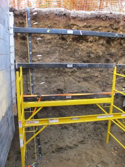
Megapit Images
D19 DEJU megapit soil profile 0-300 cm
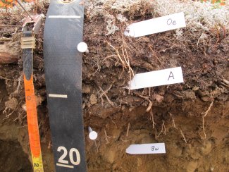
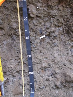
D19 DEJU megapit soil profile 0-20 cm
D19 DEJU megapit soil profile 14-33 cm
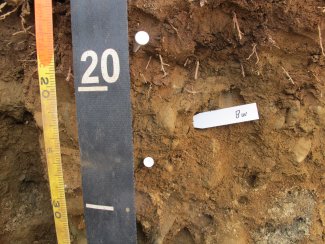
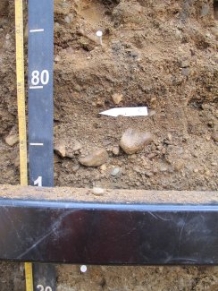
D19 DEJU megapit soil profile 23-69 cm
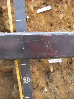
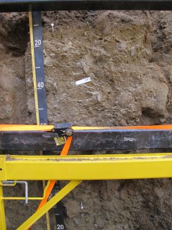
D19 DEJU megapit soil profile 66-117 cm
D19 DEJU megapit soil profile 94-214 cm
D19 DEJU megapit soil profile 199-300 cm
Megapit Pedon Description
| Print Date | Feb 18 2016 |
|---|---|
| Description Date | Jul 30 2015 |
| Describer | J Paul |
| Site ID | S2015AK240001 |
| Pedon ID | S2015AK240001 |
| Lab Source ID | KSSL |
| Lab Pedon # | 15N0739 |
| Soil Name as Described/Sampled | SND |
| Classification | Coarse-loamy, mixed, superactive Typic Haplocryepts |
| Taxon Kind | taxon above family |
| Geomorphic Setting | upper alluvial fan |
| Upslope Shape | linear |
| Cross Slope Shape | convex |
| Description origin | NASIS |
| State | Alaska |
| County | Southeast Fairbanks Census Area |
| MLRA | 229 -- Interior Alaska Lowlands |
| Soil Survey Area | AK683 -- Fort Greely and Donnelly Training Area, Alaska |
| Std Latitude | 63.8797130 |
| Std Longitude | -145.4746630 |
| Datum | WGS84 |
| Description database | KSSL |
| Diagnostic Features | ochric epipedon 0 to 16 cm. cambic horizon 16 to 40 cm. lithologic discontinuity 125 to 300 cm. |
| Slope (%) | 3.0 |
| Elevation (meters) | 505.0 |
| Drainage Class | well |
| Horizon Details |
Oe--0 to 5 centimeters (0.0 to 2.0 inches); black (10YR 2/1) broken face moderately decomposed plant material; very friable; common very fine roots and very few very coarse roots and common medium roots and common fine roots and common coarse roots; 0 percent unspecified fragments; noneffervescent, by HCl, 1 normal; clear wavy boundary. Lab sample # 15N03790 A--5 to 16 centimeters (2.0 to 6.3 inches); dark brown (7.5YR 3/3) broken face fine sandy loam; 60 percent sand; 38 percent silt; 2 percent clay; weak medium subangular blocky structure; very friable, nonsticky, nonplastic; common very fine roots and common very coarse roots and common medium roots and common fine roots and common coarse roots; 0 percent nonflat subrounded indurated 75 to 250-millimeter unspecified fragments and 0 percent nonflat subrounded indurated 250 to 600-millimeter unspecified fragments and 1 percent nonflat subrounded indurated 5 to 75-millimeter unspecified fragments and 4 percent nonflat subrounded indurated 2 to 5-millimeter unspecified fragments; noneffervescent, by HCl, 1 normal; clear wavy boundary. Lab sample # 15N03791 Bw--16 to 30 centimeters (6.3 to 11.8 inches); dark yellowish brown (10YR 4/4) broken face very fine sandy loam; 65 percent sand; 34 percent silt; 1 percent clay; weak coarse subangular blocky parts to weak medium platy structure; friable, nonsticky, nonplastic; very few very fine roots and very few very coarse roots and common medium roots and common fine roots and very few coarse roots; 0 percent nonflat subrounded indurated 75 to 250-millimeter unspecified fragments and 0 percent nonflat subrounded indurated 250 to 600-millimeter unspecified fragments and 1 percent nonflat subrounded indurated 2 to 5-millimeter unspecified fragments and 10 percent nonflat subrounded indurated 5 to 75-millimeter unspecified fragments; noneffervescent, by HCl, 1 normal; gradual wavy boundary. Lab sample # 15N03792. Measurement is 1cm short of minimum thickness for cambic horizon, but the lower boundary is defined as being "gradual and wavy". Since the horizon below did show altered colors and horizon depths are variable across pit face, the horizon is interpreted to be "cambic". BC--30 to 72 centimeters (11.8 to 28.3 inches); dark yellowish brown (10YR 3/4) broken face extremely gravelly sandy loam; 75 percent sand; 24 percent silt; 1 percent clay; structureless single grain; loose, nonsticky, nonplastic; very few very fine roots and very few very coarse roots and very few medium roots and few fine roots and very few coarse roots; 0 percent nonflat subrounded indurated 250 to 600-millimeter unspecified fragments and 2 percent nonflat subrounded indurated 75 to 250-millimeter unspecified fragments and 25 percent nonflat subrounded indurated 2 to 5-millimeter unspecified fragments and 50 percent nonflat subrounded indurated 5 to 75-millimeter unspecified fragments; noneffervescent, by HCl, 1 normal; clear smooth boundary. Lab sample # 15N03793. "BC" designation based on color of horizon and not pedogenic structure. C--72 to 125 centimeters (28.3 to 49.2 inches); stratified extremely gravelly coarse sand to gravel; 95 percent sand; 5 percent silt; structureless single grain; loose, nonsticky, nonplastic; 0 percent nonflat subrounded indurated 250 to 600-millimeter unspecified fragments and 10 percent nonflat subrounded indurated 75 to 250-millimeter unspecified fragments and 35 percent nonflat subrounded indurated 5 to 75-millimeter unspecified fragments and 45 percent nonflat subrounded indurated 2 to 5-millimeter unspecified fragments; noneffervescent, by HCl, 1 normal; clear wavy boundary. Lab sample # 15N03794 2BC1--125 to 210 centimeters (49.2 to 82.7 inches); 95 percent olive brown (2.5Y 4/3) broken face very gravelly sandy loam; 70 percent sand; 28 percent silt; 2 percent clay; 5 percent very coarse distinct irregular (2.5Y 3/2) mottles; moderate medium subangular blocky, and moderate coarse subangular blocky structure; friable, nonsticky, nonplastic; 0 percent nonflat subrounded indurated 250 to 600-millimeter unspecified fragments and 2 percent nonflat subrounded indurated 75 to 250-millimeter unspecified fragments and 15 percent nonflat subrounded indurated 2 to 5-millimeter unspecified fragments and 20 percent nonflat subrounded indurated 5 to 75-millimeter unspecified fragments; noneffervescent, by HCl, 1 normal; gradual wavy boundary. Lab sample # 15N03795. Top Depth of horizon is uneven, sloping down to the right of the pit face. Measurement of this depth taken at center of pit face. 2BC2--210 to 300 centimeters (82.7 to 118.1 inches); dark grayish brown (2.5Y 4/2) broken face very gravelly sandy loam; 60 percent sand; 32 percent silt; 8 percent clay; 5 percent very coarse prominent irregular (7.5YR 4/4) mottles; weak fine subangular blocky, and weak medium subangular blocky structure; friable, nonsticky, nonplastic; 1 percent nonflat subrounded indurated 250 to 600-millimeter unspecified fragments and 1 percent moderately cemented charcoal fragments and 15 percent nonflat subrounded indurated 2 to 5-millimeter unspecified fragments and 15 percent nonflat subrounded indurated 75 to 250-millimeter unspecified fragments and 20 percent nonflat subrounded indurated 5 to 75-millimeter unspecified fragments; noneffervescent, by HCl, 1 normal. Lab sample # 15N03796 |
Credits: This megapit soil pedon description was generously created by USDA Natural Resource Conservation Service staff, with particular thanks to Larry West, Jon Hempel, and numerous field staff.