Central Plains Experimental Range NEON (CPER) Soil Descriptions
Distributed Soils Reports
Pedon Descriptions
Pit‐level observations and field measurements reported using the standard NRCS format. They contain volume estimates for coarse fragments > 20 mm where applicable.
Site Level Plot Summary
A narrative summary that places the sampled soil pedons in the broader context of soils and geomorphology for the entire NEON site.
Megapit Images
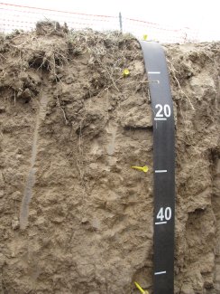
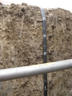
D10 CPER megapit soil profile 0-52 cm
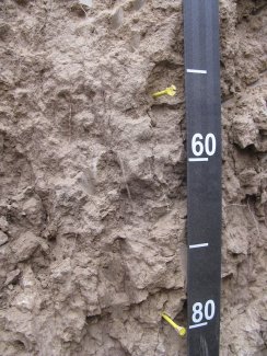
D10 CPER megapit soil profile 42-82 cm
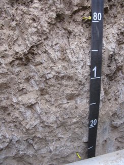
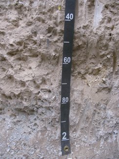
D10 CPER megapit soil profile 75-130 cm
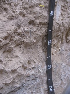
D10 CPER megapit soil profile 132-200 cm
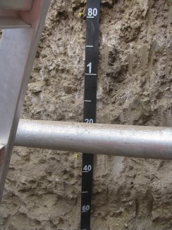
D10 CPER megapit soil profile 0-105 cm
D10 CPER megapit soil profile 75-170 cm
D10 CPER megapit soil profile 132-200 cm
Megapit Pedon Description
| Print Date | Apr 1 2015 |
|---|---|
| Description Date | Aug 13 2012 |
| Describer | Andy Steinert |
| Site ID | S12CO123001 |
| Site Note | Central Plains Experimental Range NEON Site |
| Pedon ID | S2012CO123001 |
| Lab Source ID | SSL |
| Lab Pedon # | 12N8293 |
| Soil Name as Described/Sampled | Ascalon |
| Classification | Fine-loamy, mixed, superactive, mesic Aridic Argiustolls |
| Pedon Type | correlates to named soil |
| Pedon Purpose | research site |
| Taxon Kind | series |
| Physiographic Division | Interior Plains |
| Physiographic Province | Great Plains Province |
| Physiographic Section | Colorado Piedmont |
| Geomorphic Setting | on backslope of hill |
| Upslope Shape | convex |
| Cross Slope Shape | concave |
| Particle Size Control Section | 30 to 80 cm. |
| Description origin | Pedon PC 5.0 |
| State | Colorado |
| County | Weld |
| MLRA | 67B -- Central High Plains, Southern Part |
| Soil Survey Area | CO617 -- Weld County, Colorado, Northern Part 5-FTM -- Fort Morgan, Colorado |
| Map Unit | 4 -- Ascalon fine sandy loam, 0 to 6 percent slopes |
| Quad Name | Eastman Creek South, Colorado |
| Std Latitude | 40.8131111 |
| Std Longitude | -104.7443889 |
| Latitude | 40 degrees 48 minutes 47.20 seconds north |
| Longitude | 104 degrees 44 minutes 39.80 seconds west |
| Datum | WGS84 |
| UTM Zone | 13 |
| UTM Easting | 521558 meters |
| UTM Northing | 4518042 meters |
| Primary Earth Cover | Grass/herbaceous cover |
| Secondary Earth Cover | Grassland rangeland |
| Existing Vegetation | blue grama, needle and thread, plains pricklypear, rabbitbrush, sand sagebrush |
| Parent Material | eolian deposits over residuum weathered from sandstone |
| Description database | KSSL |
| Diagnostic Features | mollic epipedon 0 to 30 cm. argillic horizon 30 to 81 cm. |
| Slope (%) | 2.0 |
| Elevation (meters) | 1,682.5 |
| Aspect (deg) | 265 |
| Drainage Class | well |
| Horizon Details |
A--0 to 10 centimeters (0.0 to 3.9 inches); brown (10YR 5/3) broken face fine sandy loam, dark brown (10YR 3/3) broken face, moist; 75 percent sand; 11 percent silt; 14 percent clay; single grain, and weak fine subangular blocky; moderately hard, very friable, nonsticky, nonplastic; common very fine roots throughout and common medium roots throughout and common fine roots throughout; noneffervescent, by HCl, 1 normal; slightly acid, pH 6.2, pH meter; clear smooth boundary. Lab sample # 12N04726 BA--10 to 30 centimeters (3.9 to 11.8 inches); brown (10YR 5/3) broken face fine sandy loam, dark brown (10YR 3/3) broken face, moist; 75 percent sand; 9 percent silt; 16 percent clay; moderate coarse subangular blocky structure; hard, very friable, nonsticky, nonplastic; common very fine roots throughout and common medium roots throughout and common fine roots throughout; noneffervescent, by HCl, 1 normal; neutral, pH 6.6, pH meter; gradual smooth boundary. Lab sample # 12N04727 Bt1--30 to 54 centimeters (11.8 to 21.3 inches); brown (10YR 5/3) broken face sandy clay loam, dark yellowish brown (10YR 4/4) broken face, moist; 60 percent sand; 16 percent silt; 24 percent clay; moderate medium prismatic parts to moderate medium angular blocky, and moderate medium prismatic parts to moderate coarse angular blocky, and moderate coarse prismatic parts to moderate medium angular blocky, and moderate coarse prismatic parts to moderate coarse angular blocky structure; very hard, friable, slightly sticky, slightly plastic; common very fine roots throughout and common fine roots throughout; 5 percent distinct clay films on all faces of peds; noneffervescent, by HCl, 1 normal; neutral, pH 7.3, pH meter; clear wavy boundary. Lab sample # 12N04728, 12N04733 Bt2--54 to 81 centimeters (21.3 to 31.9 inches); brown (10YR 5/3) broken face sandy clay loam, dark brown (10YR 3/3) broken face, moist; 55 percent sand; 14 percent silt; 31 percent clay; strong coarse prismatic parts to strong coarse angular blocky, and strong coarse prismatic parts to strong medium angular blocky, and strong medium prismatic parts to strong coarse angular blocky, and strong medium prismatic parts to strong medium angular blocky structure; extremely hard, friable, slightly sticky, moderately plastic; common very fine roots throughout and common fine roots throughout and ; 20 percent distinct clay films on all faces of peds; noneffervescent, by HCl, 1 normal; slightly alkaline, pH 7.7, pH meter; clear wavy boundary. Lab sample # 12N04729 Bk1--81 to 137 centimeters (31.9 to 53.9 inches); brown (10YR 5/3) broken face sandy clay loam, dark yellowish brown (10YR 4/6) broken face, moist; 50 percent sand; 20 percent silt; 30 percent clay; weak coarse prismatic parts to moderate coarse subangular blocky, and weak coarse prismatic parts to moderate medium subangular blocky structure; hard, very friable, moderately sticky, moderately plastic; common very fine roots throughout and common fine roots throughout; 2 percent coarse irregular carbonate masses on faces of peds and 2 percent fine threadlike carbonate masses on faces of peds and 1 percent medium irregular carbonate masses on faces of peds; strong effervescence, by HCl, 1 normal; moderately alkaline, pH 8.1, pH meter; clear wavy boundary. Lab sample # 12N04730 Bk2--137 to 181 centimeters (53.9 to 71.3 inches); brown (10YR 5/3) broken face sandy clay loam, dark yellowish brown (10YR 4/6) broken face, moist; 55 percent sand; 23 percent silt; 22 percent clay; moderate coarse subangular blocky, and moderate medium subangular blocky, and moderate fine subangular blocky structure; hard, very friable, slightly sticky, moderately plastic; common very fine roots throughout; 2 percent fine threadlike carbonate masses on faces of peds; strong effervescence, by HCl, 1 normal; moderately alkaline, pH 8.1, pH meter; abrupt broken boundary. Lab sample # 12N04731 2C--181 to 210 centimeters (71.3 to 82.7 inches); light gray (10YR 7/2) broken face silty clay loam, light gray (10YR 7/1) broken face, moist; 18 percent sand; 50 percent silt; 32 percent clay; structureless massive; loose, loose, moderately sticky, moderately plastic; common very fine roots throughout; 2 percent fine threadlike carbonate masses on faces of peds and 1 percent fine irregular carbonate masses on faces of peds; 6 percent nonflat angular very strongly cemented 5 to 20-millimeter sandstone fragments; strong effervescence, by HCl, 1 normal; moderately alkaline, pH 7.9, pH meter. Lab sample # 12N04737, 12N04732 |
Credits: This megapit soil pedon description was generously created by USDA Natural Resource Conservation Service staff, with particular thanks to Larry West, Jon Hempel, and numerous field staff.