Lyndon B. Johnson National Grassland NEON (CLBJ) Soil Descriptions
Distributed Soils Reports
Pedon Descriptions
Pit‐level observations and field measurements reported using the standard NRCS format. They contain volume estimates for coarse fragments > 20 mm where applicable.
Site Level Plot Summary
A narrative summary that places the sampled soil pedons in the broader context of soils and geomorphology for the entire NEON site.
Megapit Images
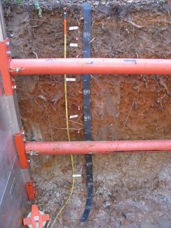
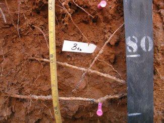
D11 CLBJ megapit soil profile 0-140 cm
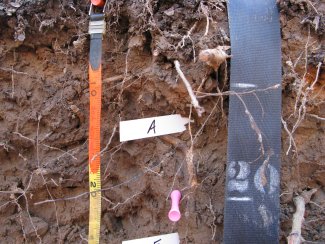
D11 CLBJ megapit soil profile 0-25 cm
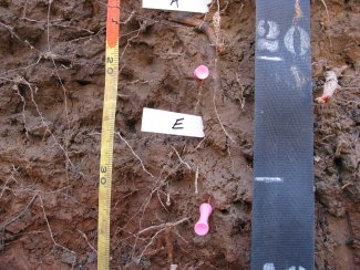
D11 CLBJ megapit soil profile 15-38 cm
D11 CLBJ megapit soil profile 38-83 cm
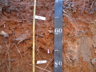
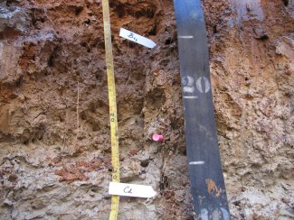
D11 CLBJ megapit soil profile 69-92 cm
D11 CLBJ megapit soil profile 90-119 cm
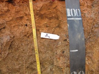
D11 CLBJ megapit soil profile 97-137 cm
Megapit Pedon Description
| Print Date | Feb 7 2018 |
|---|---|
| Description Date | May 9 2016 |
| Describer | Sidney Paulson |
| Site ID | S2016TX497001_MP |
| Site Note | Site of NEON Megapit at the LBJ National Grasslands. |
| Pedon ID | S2016TX497001 |
| Lab Source ID | KSSL |
| Lab Pedon # | 16N0686 |
| Soil Name as Described/Sampled | Windthorst |
| Classification | Fine, mixed, active, thermic Udic Paleustalfs |
| Pedon Type | correlates to named soil |
| Pedon Purpose | research site |
| Taxon Kind | series |
| Physiographic Division | Interior Plains |
| Physiographic Province | Central Lowland Province |
| Geomorphic Setting | on backslope of side slope of ridge on hill |
| Upslope Shape | linear |
| Cross Slope Shape | linear |
| Particle Size Control Section | 34 to 84 cm. |
| Description origin | NASIS |
| State | Texas |
| County | Wise |
| MLRA | 84B -- West Cross Timbers |
| Soil Survey Area | TX497 -- Wise County, Texas |
| Map Unit | WeC -- Duffau-Windthorst complex, 1 to 5 percent slopes, moderately eroded |
| Quad Name | New Harp, Texas |
| Std Latitude | 33.4014300 |
| Std Longitude | -97.5672500 |
| Latitude | 33 degrees 24 minutes 5.14 seconds north |
| Longitude | 97 degrees 34 minutes 2.10 seconds west |
| Datum | WGS84 |
| UTM Zone | 14 |
| UTM Easting | 633238 meters |
| UTM Northing | 3696708 meters |
| Primary Earth Cover | Grass/herbaceous cover |
| Secondary Earth Cover | Savanna rangeland |
| Existing Vegetation | cedar elm, eastern redcedar, post oak, saw greenbrier |
| Parent Material | loamy and/or clayey residuum weathered from sandstone |
| Bedrock Kind | sandstone |
| Bedrock Depth | 122 centimeters |
| Bedrock Hardness | noncemented |
| Bedrock Fracture Interval | 10 to less than 45 centimeters |
| Description database | KSSL |
| Diagnostic Features | ochric epipedon 0 to 34 cm. argillic horizon 34 to 122 cm. densic contact 122 to cm. densic materials 122 to 152 cm. |
| Top Depth (cm) | 122 |
| Bottom Depth (cm) | 152 |
| Restriction Kind | bedrock, densic |
| Restriction Hardness | noncemented |
| Slope (%) | 4.0 |
| Elevation (meters) | 274.3 |
| Aspect (deg) | 150 |
| Drainage Class | moderately well |
| Horizon Details |
A--0 to 21 centimeters (0.0 to 8.3 inches); brown (7.5YR 5/3) fine sandy loam, brown (7.5YR 4/3), moist; 15 percent clay; moderate fine subangular blocky, and moderate medium subangular blocky structure; slightly hard, very friable, noncemented, nonsticky, nonplastic; many very fine roots throughout and common medium roots throughout and many fine roots throughout and common coarse roots throughout; common fine high-continuity irregular pores; noneffervescent, by HCl, 1 normal; clear smooth boundary. Lab sample # 16N03043 E--21 to 34 centimeters (8.3 to 13.4 inches); pink (7.5YR 7/3) fine sandy loam, light brown (7.5YR 6/3), moist; 10 percent clay; moderate fine subangular blocky, and moderate medium subangular blocky structure; slightly hard, very friable, noncemented, nonsticky, nonplastic; common very fine roots throughout and common medium roots throughout and many fine roots throughout; common fine high-continuity irregular pores; noneffervescent, by HCl, 1 normal; clear smooth boundary. Lab sample # 16N03044 Bt1--34 to 71 centimeters (13.4 to 28.0 inches); red (2.5YR 5/8) clay, red (2.5YR 4/8), moist; 44 percent clay; moderate medium prismatic parts to moderate medium angular blocky structure; very hard, firm, noncemented, moderately sticky, moderately plastic; common very fine roots throughout and common medium roots throughout and many fine roots throughout; common fine high-continuity dendritic tubular pores; 80 percent distinct clay films on all faces of peds; noneffervescent, by HCl, 1 normal; gradual smooth boundary. Lab sample # 16N03045 Bt2--71 to 89 centimeters (28.0 to 35.0 inches); red (2.5YR 5/8) sandy clay, red (2.5YR 4/8), moist; 37 percent clay; moderate medium prismatic parts to moderate medium angular blocky structure; very hard, firm, noncemented, moderately sticky, moderately plastic; common very fine roots throughout and common medium roots throughout and common fine roots throughout; 60 percent distinct clay films on all faces of peds; 1 percent very fine distinct irregular extremely weakly cemented 7.5YR 2.5/1), moist, iron-manganese concretions with clear boundaries throughout; noneffervescent, by HCl, 1 normal; clear smooth boundary. Lab sample # 16N03046 Bt3--89 to 122 centimeters (35.0 to 48.0 inches); pale brown (10YR 6/3) sandy clay loam, pale brown (10YR 6/3), moist; 32 percent clay; weak medium prismatic parts to moderate medium angular blocky structure; hard, firm, noncemented, slightly sticky, slightly plastic; common medium roots throughout and common fine roots throughout; 20 percent distinct clay films on all faces of peds; 1 percent very fine distinct irregular extremely weakly cemented 7.5YR 2.5/1), moist, iron-manganese concretions with clear boundaries throughout and 40 percent medium prominent irregular 5YR 6/8), moist, masses of oxidized iron with clear boundaries throughout; noneffervescent, by HCl, 1 normal; abrupt smooth boundary. Lab sample # 16N03047 Cd--122 to 152 centimeters (48.0 to 59.8 inches); very pale brown (10YR 8/2) loamy very fine sand, light gray (10YR 7/2), moist; 6 percent clay; massive; noncemented; common medium roots in cracks; noneffervescent, by HCl, 1 normal; Dark organic stains are present along root channels in the cracks and fracture planes of the lower part of this layer. Lab sample # 16N03048. |
Credits: This megapit soil pedon description was generously created by USDA Natural Resource Conservation Service staff, with particular thanks to Larry West, Jon Hempel, and numerous field staff.