Blandy Experimental Farm NEON (BLAN) Soil Descriptions
Distributed Soils Reports
Pedon Descriptions
Pit‐level observations and field measurements reported using the standard NRCS format. They contain volume estimates for coarse fragments > 20 mm where applicable.
Site Level Plot Summary
A narrative summary that places the sampled soil pedons in the broader context of soils and geomorphology for the entire NEON site.
Megapit Images
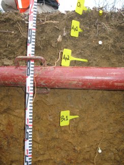
D02 BLAN megapit soil profile 0-53 cm
D02 BLAN megapit soil profile 14-90 cm
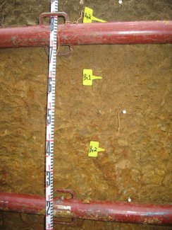
D02 BLAN megapit soil profile 50-140 cm
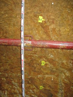
D02 BLAN megapit soil profile 113-200 cm
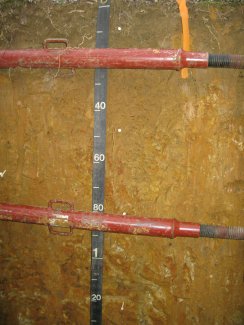
D02 BLAN megapit soil profile 0-135 cm
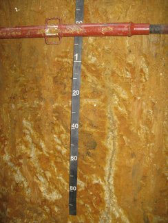
D02 BLAN megapit soil profile 63-200 cm
Megapit Pedon Description
| Print Date | Jul 22 2015 |
|---|---|
| Description Date | Jan 14 2013 |
| Describer | Don Flegel |
| Site ID | S13VA-043-1 |
| Pedon Note | This pedon is named Poplimento-like due to the fact that the solum thickness does not meet the required range of 40 to 70 inches (102-178 cm) and the drainage class is moderately well drained.; The C1 and C2 horizons gray colors are dominantly clay, the redder colors are dominantly silt loam and the brownish colors are dominantly silty clay.; The C1 and C2 horizons consist of very highly weathered shale, siltstone and fine-grained sandstone fragments. The gray colors in the C1 and C2 horizons follow root channels vertically from a depth of 33-inches (84cm) to the bottom of the profile. This same situation has been observed in areas mapped Poplimento by other soil scientists but a moderately well drained counterpart has not been established due to the olimited acreage.; The seven horizons have been sampled by the NEON staff and will be sent to the NRCAS Kellogg Lab. |
| Pedon ID | S2013VA043001 |
| Lab Source ID | SSL |
| Lab Pedon # | 13N0377 |
| Soil Name as Described/Sampled | Poplimento |
| Classification | Fine, mixed, subactive, mesic Ultic Hapludalfs |
| Soil Name as Correlated | Poplimento |
| Pedon Purpose | laboratory sampling site |
| Taxon Kind | series |
| Geomorphic Setting | None Assigned |
| Description origin | NASIS |
| Soil Survey Area | VA043 -- Clarke County, Virginia |
| Std Latitude | 39.0601300 |
| Std Longitude | -78.0713500 |
| Latitude | 39 degrees 3 minutes 36.47 seconds north |
| Longitude | 78 degrees 4 minutes 16.86 seconds west |
| Datum | WGS84 |
| Description database | KSSL |
| Diagnostic Features | agric horizon to cm. |
| Drainage Class | well |
| Horizon Details |
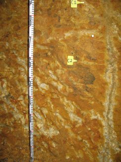
O--0 to 2 centimeters (0.0 to 0.8 inches); slightly decomposed plant material; very abrupt smooth boundary. Ap1--2 to 14 centimeters (0.8 to 5.5 inches); dark yellowish brown (10YR 3/6) broken face silt loam; moderate medium granular, and moderate coarse granular structure; friable, slightly sticky, slightly plastic; many very fine roots throughout and many medium roots throughout; 5 percent sandstone fragments; clear smooth boundary. Lab sample # 13N01586, 13N01592 Ap2--14 to 23 centimeters (5.5 to 9.1 inches); silt loam; moderate fine subangular blocky, and moderate medium subangular blocky structure; friable, slightly sticky, slightly plastic; common very fine roots throughout and common medium roots throughout; 5YR 2.5/1) manganese masses; 5 percent sandstone fragments; abrupt smooth boundary. Lab sample # 13N01587 Bt1--23 to 51 centimeters (9.1 to 20.1 inches); silty clay loam; moderate medium subangular blocky structure; firm, moderately sticky, moderately plastic; common very fine roots between peds and common medium roots between peds; 35 percent distinct clay films on surfaces along pores; 5YR 2.5/1) manganese masses; 5 percent sandstone fragments; gradual wavy boundary. Lab sample # 13N01588 Bt2--51 to 84 centimeters (20.1 to 33.1 inches); silty clay; 10 percent coarse prominent (10YR 4/8) and 10 percent medium faint (10YR 7/8) mottles; weak medium subangular blocky structure; firm, very sticky, very plastic; few very fine roots between peds and few medium roots between peds; 35 percent distinct clay films on surfaces along pores and 35 percent distinct clay films on top faces of peds; 5YR 2.5/1) manganese masses; 2 percent sandstone fragments; gradual wavy boundary. Lab sample # 13N01589 C1--84 to 128 centimeters (33.1 to 50.4 inches); brownish yellow (10YR 6/8) broken face and red (2.5YR 4/8) broken face silty clay; massive; friable, very sticky, very plastic; few very fine roots in cracks and few coarse roots in cracks; 10YR 7/1) reduced matrix and 10YR 3/1) manganese masses; 35 percent unspecified fragments; abrupt wavy boundary. Lab sample # 13N01590 C2--128 to 206 centimeters (50.4 to 81.1 inches); silty clay; massive; friable; few fine roots in cracks and few fine roots in cracks; 2.5Y 8/2) reduced matrix and 2.5Y 2.5/1) manganese masses. Lab sample # 13N01591. |
Credits: This megapit soil pedon description was generously created by USDA Natural Resource Conservation Service staff, with particular thanks to Larry West, Jon Hempel, and numerous field staff.