Bartlett Experimental Forest NEON (BART) Soil Descriptions
Distributed Soils Reports
Pedon Descriptions
Pit‐level observations and field measurements reported using the standard NRCS format. They contain volume estimates for coarse fragments > 20 mm where applicable.
Site Level Plot Summary
A narrative summary that places the sampled soil pedons in the broader context of soils and geomorphology for the entire NEON site.
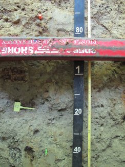
Megapit Images
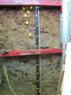
D01 BART megapit soil profile 0-195 cm
D01 BART megapit soil profile 0-25 cm
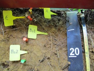
D01 BART megapit soil profile 18-51 cm
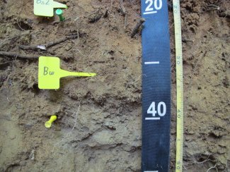
D01 BART megapit soil profile 37-80 cm
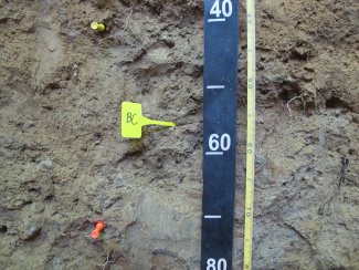
D01 BART megapit soil profile 64-149 cm

D01 BART megapit soil profile 138-200 cm
Megapit Pedon Description
| Print Date | Jul 22 2015 |
|---|---|
| Description Date | Aug 19 2013 |
| Describer | Karen Dudley |
| Site ID | S2013NH003001 |
| Pedon ID | S2013NH003001 |
| Lab Source ID | KSSL |
| Lab Pedon # | 13N97267 |
| Pedon Type | undefined observation |
| State | New Hampshire |
| MLRA | 143 -- Northeastern Mountains |
| Soil Survey Area | NH605 -- White Mountain National Forest, New Hampshire and Maine 12-STJ -- Saint Johnsbury, Vermont |
| Latitude | 44 degrees 3 minutes 54.58 seconds north |
| Longitude | 71 degrees 17 minutes 18.02 seconds west |
| Datum | WGS84 |
| Physiographic Division | Appalachian Highlands |
| Physiographic Province | New England Province |
| Physiographic Section | White Mountain section |
| Geomorphic Setting | on footslope of upland |
| Description origin | Pedon PC 6.1B |
| Primary Earth Cover | Tree cover |
| Secondary Earth Cover | Hardwoods |
| Existing Vegetation | American beech, paper birch, red maple, yellow birch |
| Parent Material | till |
| Description database | KSSL |
| Cont. Site ID | S2013NH003001 |
| Drainage Class | moderately well |
| Horizon Details |
Oe--0 to 3 centimeters (0.0 to 1.2 inches); black (10YR 2/1) moderately decomposed plant material; many very fine roots and many medium roots and many fine roots; clear wavy boundary. Lab sample # 13N12243 A--3 to 5 centimeters (1.2 to 2.0 inches); black (7.5YR 2.5/1) very fine sandy loam; weak fine granular structure; very friable; many very fine roots and common medium roots and many fine roots; 1 percent 2 to 75-millimeter unspecified fragments; clear wavy boundary. Lab sample # 13N12244 E--5 to 9 centimeters (2.0 to 3.5 inches); brown (7.5YR 5/2) sandy loam; weak fine granular structure; very friable; many very fine roots and common medium roots and many fine roots; 2 percent 2 to 75-millimeter unspecified fragments; clear wavy boundary. Lab sample # 13N12245 Bs1--9 to 15 centimeters (3.5 to 5.9 inches); brown (7.5YR 4/4) very fine sandy loam; weak fine granular structure; very friable; many very fine roots and many medium roots and many fine roots; 2 percent 75 to 250-millimeter unspecified fragments and 5 percent 2 to 75-millimeter unspecified fragments; clear wavy boundary. Lab sample # 13N12246 Bs2--15 to 22 centimeters (5.9 to 8.7 inches); dark yellowish brown (10YR 4/6) very fine sandy loam; moderate very fine granular structure; friable; many very fine roots and many medium roots and many fine roots and common coarse roots; 5 percent 2 to 75-millimeter unspecified fragments; clear wavy boundary. Lab sample # 13N12247 Bw--22 to 40 centimeters (8.7 to 15.7 inches); yellowish brown (10YR 5/6) sandy loam; weak fine subangular blocky, and weak medium subangular blocky structure; friable; many very fine roots and common medium roots and many fine roots; 5 percent 2 to 75-millimeter unspecified fragments; clear smooth boundary. Lab sample # 13N12248 BC--40 to 73 centimeters (15.7 to 28.7 inches); light yellowish brown (2.5Y 6/3) loamy sand; weak medium subangular blocky structure; friable; common very fine roots and common fine roots; 5 percent 10YR 4/6); 5 percent 2 to 250-millimeter unspecified fragments; clear smooth boundary. Lab sample # 13N12249C1--73 to 140 centimeters (28.7 to 55.1 inches); light olive brown (2.5Y 5/3) loamy sand; massive; friable; 2 percent 2.5Y 7/2) iron depletions and 10 percent 10YR 5/6); 5 percent 2 to 250-millimeter unspecified fragments; clear smooth boundary. Lab sample # 13N12250. firm consistence parting to friable C2--140 to 200 centimeters (55.1 to 78.7 inches); olive (5Y 5/4) loamy sand; friable; 7 percent 250 to 600-millimeter unspecified fragments and 10 percent 2 to 250-millimeter unspecified fragments. Lab sample # 13N12251 |
Credits: This megapit soil pedon description was generously created by USDA Natural Resource Conservation Service staff, with particular thanks to Larry West, Jon Hempel, and numerous field staff.