KU Field Station NEON (UKFS) Soil Descriptions
Distributed Soils Reports
Pedon Descriptions
Pit‐level observations and field measurements reported using the standard NRCS format. They contain volume estimates for coarse fragments > 20 mm where applicable.
Site Level Plot Summary
A narrative summary that places the sampled soil pedons in the broader context of soils and geomorphology for the entire NEON site.
Megapit Images
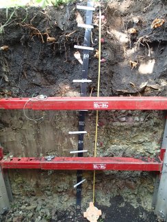
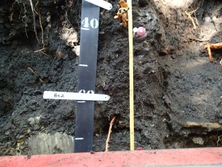
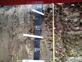
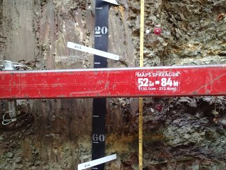
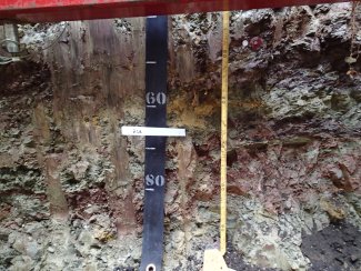
D06 UKFS megapit soil profile 0-195 cm
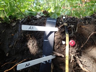
D06 UKFS megapit soil profile 0-25 cm
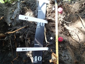
D06 UKFS megapit soil profile 8-42 cm
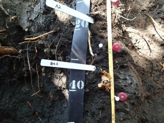
D06 UKFS megapit soil profile 13-51 cm
D06 UKFS megapit soil profile 35-75 cm
D06 UKFS megapit soil profile 79-130 cm
D06 UKFS megapit soil profile 110-170 cm
D06 UKFS megapit soil profile 142-195 cm
Megapit Pedon Description
| Print Date | Jul 22 2015 |
|---|---|
| Description Date | Jul 21 2014 |
| Describer | D. Kohake, J. Hellerich, A. Baldwin, C. Remley, J. Anderson |
| Site ID | S2014KS045001 |
| Site Note | Sampled the shale residual component of a 7550 Rosendale-Bendena map unit. |
| Pedon ID | S2014KS045001 |
| Pedon Note | This profile is a taxadjunct to the Rosendale series. It is similar to Rosendale being a residual soil in the lower half of the profile, but it has a thicker dark mollic surface and an argillic horizon that Rosendale doesn't have. |
| Lab Source ID | KSSL |
| Lab Pedon # | 14N0941 |
| Soil Name as Described/Sampled | Rosendale |
| Classification | Fine, smectitic, mesic Pachic Argiudolls |
| Pedon Type | taxadjunct to the series |
| Pedon Purpose | laboratory sampling site |
| Taxon Kind | taxadjunct |
| Physiographic Division | Interior Plains |
| Physiographic Province | Central Lowland Province |
| Physiographic Section | Dissected till plains |
| State Physiographic Area | Glaciated Region |
| Geomorphic Setting | on footslope of side slope of hillslope on upland |
| Upslope Shape | concave |
| Cross Slope Shape | linear |
| Particle Size Control Section | 28 to 78 cm. |
| Description origin | NASIS |
| State | Kansas |
| County | Douglas |
| MLRA | 106 -- Nebraska and Kansas Loess-Drift Hills |
| Soil Survey Area | KS045 -- Douglas County, Kansas 5-LIN -- Lincoln, Nebraska |
| Map Unit | 7550 -- Rosendale-Bendena silty clay loams, 3 to 40 percent slopes |
| Quad Name | Midland, Kansas |
| Std Latitude | 39.0417500 |
| Std Longitude | -95.2043889 |
| Latitude | 39 degrees 2 minutes 30.30 seconds north |
| Longitude | 95 degrees 12 minutes 15.80 seconds west |
| Datum | WGS84 |
| UTM Zone | 15 |
| UTM Easting | 309221 meters |
| UTM Northing | 4323722 meters |
| Primary Earth Cover | Tree cover |
| Secondary Earth Cover | Other tree cover |
| Parent Material | colluvium over residuum weathered from shale |
| Description database | KSSL |
| Diagnostic Features | mollic epipedon 0 to 76 cm. argillic horizon 28 to 121 cm. lithologic discontinuity 76 to 76 cm. secondary carbonates 101 to 121 cm. |
| Slope (%) | 3.0 |
| Elevation (meters) | 304.0 |
| Aspect (deg) | 270 |
| Drainage Class | moderately well |
| Horizon Details |
A1--0 to 13 centimeters (0.0 to 5.1 inches); black (10YR 2/1) broken face silty clay loam; 30 percent clay; moderate medium granular structure; slightly hard, friable; many very fine roots throughout and common fine roots throughout and common coarse roots throughout; 1 percent flat angular indurated 5 to 20-millimeter limestone fragments; noneffervescent, by HCl, 1 normal; abrupt wavy boundary. Lab sample # 14N04657. 3 bulk density clods sampled A2--13 to 28 centimeters (5.1 to 11.0 inches); black (10YR 2/1) broken face silty clay loam; 34 percent clay; moderate very fine subangular blocky structure; slightly hard, friable; many very fine roots throughout and common fine roots throughout and common coarse roots throughout; 1 percent flat angular indurated 5 to 20-millimeter limestone fragments; noneffervescent, by HCl, 1 normal; abrupt wavy boundary. Lab sample # 14N04658. 3 bulk density clods sampled Bt1--28 to 43 centimeters (11.0 to 16.9 inches); very dark brown (10YR 2/2) broken face silty clay; 40 percent clay; moderate fine subangular blocky structure; hard, firm; many very fine roots throughout and common fine roots throughout; 10 percent faint clay films on all faces of peds; 2 percent nonflat subrounded strongly cemented 5 to 20-millimeter limestone fragments; noneffervescent, by HCl, 1 normal; clear wavy boundary. Lab sample # 14N04659. 3 bulk density clods and 2 natural fabric clods sampled Bt2--43 to 76 centimeters (16.9 to 29.9 inches); very dark brown (10YR 2/2) broken face silty clay; 42 percent clay; moderate medium subangular blocky structure; hard, firm; common very fine roots throughout and few very coarse roots throughout; 15 percent distinct clay films on all faces of peds; 3 percent nonflat subangular indurated 20 to 76-millimeter limestone fragments; noneffervescent, by HCl, 1 normal; abrupt wavy boundary. Lab sample # 14N04660. line of flagstone sized limestone fragments found at the bottom of this horizon, 3 bulk density clods and 2 natural fabric clods sampled 2Bt3--76 to 101 centimeters (29.9 to 39.8 inches); 50 percent dark grayish brown (10YR 4/2) broken face and 50 percent reddish brown (5YR 4/3) broken face clay; weak medium subangular blocky structure; very hard, very firm; common very fine roots throughout and common fine roots throughout; 5 percent distinct slickensides (geogenic) and 10 percent distinct clay films on all faces of peds; 1 percent flat subangular very strongly cemented 20 to 76-millimeter limestone fragments and 2 percent flat subangular very strongly cemented 2 to 5-millimeter limestone fragments and 2 percent flat subangular very strongly cemented 5 to 20-millimeter limestone fragments; strong effervescence, by HCl, 1 normal; clear wavy boundary. Lab sample # 14N04661. the multiple colors are from the variegated weathered shale, 3 bulk density clods and 2 natural fabric clods sampled 2Btk--101 to 121 centimeters (39.8 to 47.6 inches); 80 percent light olive brown (2.5Y 5/3) broken face and 20 percent reddish brown (2.5YR 4/3) broken face clay; weak medium subangular blocky structure; very hard, very firm; common very fine roots throughout; 5 percent distinct slickensides (geogenic) and 10 percent faint clay films on all faces of peds; 2 percent medium distinct spherical very strongly cemented carbonate concretions throughout; 1 percent flat subangular very strongly cemented 5 to 20-millimeter limestone fragments and 1 percent flat subangular very strongly cemented 20 to 76-millimeter limestone fragments; strong effervescence, by HCl, 1 normal; clear wavy boundary. Lab sample # 14N04662. the multiple colors are from the variegated weathered shale, 3 bulk density clods and 2 natural fabric clods sampled 2C1--121 to 148 centimeters (47.6 to 58.3 inches); 50 percent reddish brown (2.5YR 4/3) broken face and 40 percent light yellowish brown (2.5Y 6/3) broken face and 10 percent olive yellow (2.5Y 6/8) broken face clay; structureless massive; very hard, very firm; common very fine roots throughout and common medium roots throughout; 5 percent distinct slickensides (geogenic); 1 percent flat subangular very strongly cemented 20 to 76-millimeter limestone fragments and 2 percent flat subangular very strongly cemented 5 to 20-millimeter limestone fragments; strong effervescence, by HCl, 1 normal; gradual wavy boundary. Lab sample # 14N04663. the multiple colors are from the variegated weathered shale, there was some geologic platy structure from the shale still evident, 3 bulk density clods and 2 natural fabric clods sampled 2C2--148 to 200 centimeters (58.3 to 78.7 inches); 60 percent light brownish gray (2.5Y 6/2) broken face and 40 percent reddish brown (2.5YR 4/4) broken face clay; structureless massive; very hard, extremely firm; common very fine roots in cracks; 5 percent distinct slickensides (geogenic); 3 percent nonflat subrounded weakly cemented 5 to 20-millimeter mudstone fragments and 4 percent nonflat subrounded very strongly cemented 20 to 76-millimeter limestone fragments and 7 percent nonflat subrounded weakly cemented 20 to 76-millimeter mudstone fragments; strong effervescence, by HCl, 1 normal. Lab sample # 14N04664. the multiple colors are from the variegated weathered shale, there was some geologic platy structure from the shale still evident, 3 bulk density clods and 2 natural fabric clods sampled |
Credits: This megapit soil pedon description was generously created by USDA Natural Resource Conservation Service staff, with particular thanks to Larry West, Jon Hempel, and numerous field staff.