Santa Rita Experimental Range NEON (SRER) Soil Descriptions
Distributed Soils Reports
Pedon Descriptions
Pit‐level observations and field measurements reported using the standard NRCS format. They contain volume estimates for coarse fragments > 20 mm where applicable.
Site Level Plot Summary
A narrative summary that places the sampled soil pedons in the broader context of soils and geomorphology for the entire NEON site.
Megapit Images
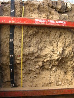
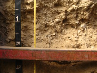
D14 SRER megapit soil profile 0-122 cm
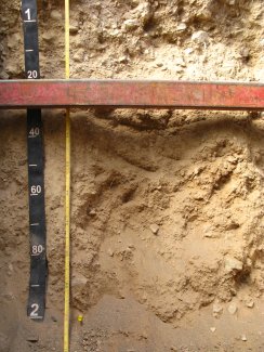
D14 SRER megapit soil profile 94-200 cm
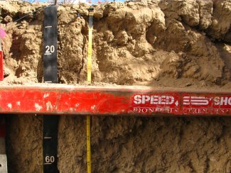
D14 SRER megapit soil profile 0-63 cm
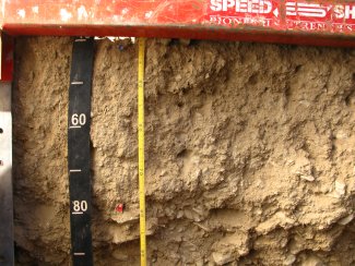
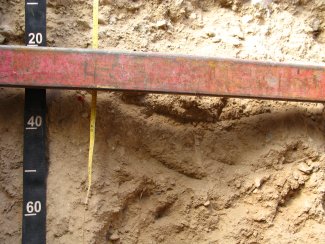
D14 SRER megapit soil profile 39-93 cm
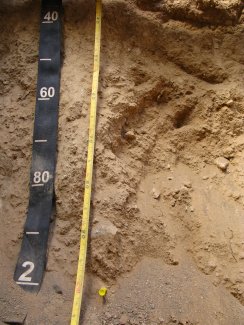
D14 SRER megapit soil profile 82-143 cm
D14 SRER megapit soil profile 109-168 cm
D14 SRER megapit soil profile 135-200 cm
Megapit Pedon Description
| Print Date | Apr 8 2015 |
|---|---|
| Description Date | Nov 6 2013 |
| Describer | Svetlik and McGuire |
| Site ID | S2013AZ0193000 |
| Pedon ID | S2013AZ0193000 |
| Lab Source ID | KSSL |
| Lab Pedon # | 14N0143 |
| Soil Name as Described/Sampled | Rillino |
| Classification | Coarse-loamy, mixed, superactive, thermic Typic Haplocalcids |
| Soil Name as Described/Sampled | Anthony |
| Classification | Coarse-loamy, mixed, calcareous, thermic Typic Torrifluvents |
| Pedon Type | TUD pedon |
| Pedon Purpose | research site |
| Taxon Kind | series |
| Geomorphic Setting | on tread of None Assigned |
| Upslope Shape | linear |
| Cross Slope Shape | linear |
| Particle Size Control Section | 25 to 100 cm. |
| Description origin | NASIS |
| State | Arizona |
| County | Pima |
| MLRA | 42 -- Southern Desertic Basins, Plains, and Mountains |
| Soil Survey Area | 40 -- Sonoran Basin and Range 8-LAS -- Las Cruces, New Mexico |
| Std Latitude | 31.9086667 |
| Std Longitude | -110.8377778 |
| Latitude | 31 degrees 54 minutes 31.20 seconds north |
| Longitude | 110 degrees 50 minutes 16.00 seconds west |
| Datum | WGS84 |
| Primary Earth Cover | Shrub cover |
| Secondary Earth Cover | Shrubby rangeland |
| Existing Vegetation | Arizona pencil cholla, barrel cactus, bush muhly, creosote bush, pricklypear, saguaro |
| Parent Material | mixed alluvium |
| Surface Fragments | 5.0 percent nonflat subrounded indurated 2- to 75-millimeter |
| Description database | KSSL |
| Diagnostic Features | ochric epipedon 0 to 5 cm. cambic horizon 5 to 41 cm. calcic horizon 41 to 203 cm. |
| Slope (%) | 2.0 |
| Elevation (meters) | 996.0 |
| Aspect (deg) | 270 |
| MAAT (C) | 19.4 |
| MAP (mm) | 280 |
| Frost-Free Days | 250 |
| Drainage Class | well |
| Horizon Details |
A--0 to 5 centimeters (0.0 to 2.0 inches); brown (7.5YR 5/4) sandy loam, brown (7.5YR 4/4), moist; 75 percent sand; 18 percent silt; 7 percent clay; moderate medium platy, and moderate thick platy structure; soft, very friable, nonsticky, nonplastic; low excavation difficulty; few very fine roots; common very fine tubular and common fine vesicular pores; 7.0 percent calcium carbonate equivalent; violent effervescence, by HCl, 1 normal; slightly alkaline, pH 7.8, pH indicator solutions; abrupt smooth boundary. Lab sample # 14N00454 Bw--5 to 41 centimeters (2.0 to 16.1 inches); brown (7.5YR 5/4) sandy loam, brown (7.5YR 4/3), moist; 80 percent sand; 8 percent silt; 12 percent clay; moderate fine subangular blocky, and moderate medium subangular blocky structure; slightly hard, very friable, nonsticky, nonplastic; low excavation difficulty; common very fine roots and common fine roots; many very fine tubular and many very fine interstitial pores; carbonate, finely disseminated; 2 percent nonflat subrounded indurated 2 to 75-millimeter unspecified fragments; 16.0 percent calcium carbonate equivalent; violent effervescence, by HCl, 1 normal; moderately alkaline, pH 8.0, pH indicator solutions; clear smooth boundary. Lab sample # 14N00455 Bk1--41 to 79 centimeters (16.1 to 31.1 inches); light brown (7.5YR 6/3) sandy loam, brown (7.5YR 4/3), moist; 80 percent sand; 8 percent silt; 12 percent clay; moderate fine subangular blocky, and moderate medium subangular blocky structure; slightly hard, very friable, nonsticky, nonplastic; low excavation difficulty; many very fine roots; many very fine tubular pores; 30 percent distinct carbonate coats on rock fragments; 2 percent very fine distinct carbonate masses; 10 percent nonflat subrounded indurated 2 to 75-millimeter unspecified fragments; 26.0 percent calcium carbonate equivalent; violent effervescence, by HCl, 1 normal; moderately alkaline, pH 8.0, pH indicator solutions; abrupt smooth boundary. Lab sample # 14N00456 Bk2--79 to 132 centimeters (31.1 to 52.0 inches); light brown (7.5YR 6/4) very gravelly sandy loam, brown (7.5YR 5/4), moist; 80 percent sand; 10 percent silt; 10 percent clay; structureless massive; soft, very friable, nonsticky, nonplastic; low excavation difficulty; many very fine roots; many very fine interstitial pores; 60 percent distinct carbonate coats on rock fragments; 45 percent nonflat subrounded indurated 2 to 75-millimeter unspecified fragments; 17.0 percent calcium carbonate equivalent; violent effervescence, by HCl, 1 normal; moderately alkaline, pH 8.0, pH indicator solutions; abrupt smooth boundary. Lab sample # 14N00457 2Bk--132 to 203 centimeters (52.0 to 79.9 inches); strong brown (7.5YR 5/6) loam, brown (7.5YR 4/4), moist; 50 percent sand; 32 percent silt; 18 percent clay; moderate fine subangular blocky, and moderate medium subangular blocky structure; slightly hard, friable, slightly sticky, slightly plastic; low excavation difficulty; common very fine roots; many very fine tubular pores; 30 percent distinct carbonate coats on rock fragments; 25 percent very fine carbonate masses; 5 percent nonflat subrounded indurated 2 to 75-millimeter unspecified fragments; 12.0 percent calcium carbonate equivalent; violent effervescence, by HCl, 1 normal; moderately alkaline, pH 8.0, pH indicator solutions. Lab sample # 14N00458 |
Credits: This megapit soil pedon description was generously created by USDA Natural Resource Conservation Service staff, with particular thanks to Larry West, Jon Hempel, and numerous field staff.