Onaqui NEON (ONAQ) Soil Descriptions
Distributed Soils Reports
Pedon Descriptions
Pit‐level observations and field measurements reported using the standard NRCS format. They contain volume estimates for coarse fragments > 20 mm where applicable.
Site Level Plot Summary
A narrative summary that places the sampled soil pedons in the broader context of soils and geomorphology for the entire NEON site.
Megapit Images
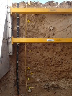
D15 ONAQ megapit soil profile 0-200 cm
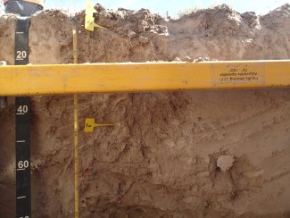
D15 ONAQ megapit soil profile 0-81 cm
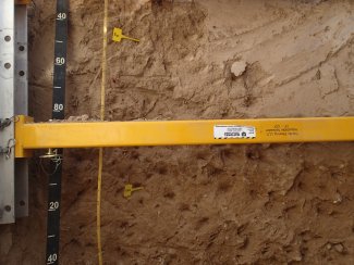
D15 ONAQ megapit soil profile 34-146 cm
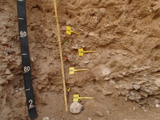
D15 ONAQ megapit soil profile 140-200 cm
Megapit Pedon Description
| Print Date | Jul 22 2015 |
|---|---|
| Description Date | Jun 2 2014 |
| Describer | Randy Lewis; Ray Grow |
| Site ID | 14UT611001RJL |
| Pedon ID | S2014UT045001 |
| Lab Source ID | KSSL |
| Lab Pedon # | 14N0856 |
| Soil Name as Described/Sampled | Taylorsflat |
| Classification | Fine-loamy, mixed, superactive, mesic Xeric Haplocalcids |
| Pedon Type | correlates to named soil |
| Pedon Purpose | research site |
| Taxon Kind | series |
| Geomorphic Setting | fan remnant |
| Upslope Shape | concave |
| Cross Slope Shape | convex |
| Particle Size Control Section | 25 to 100 cm. |
| Description origin | NASIS |
| State | Utah |
| County | Tooele |
| MLRA | 28A -- Great Salt Lake Area |
| Soil Survey Area | UT611 -- Tooele Area, Utah - Tooele County and Parts of Box Elder, Davis and Juab Counties 8-LAS -- Las Cruces, New Mexico |
| Map Unit | 64 -- Taylorsflat loam, 1 to 5 percent slopes |
| Quad Name | Faust, Utah |
| Std Latitude | 40.1783389 |
| Std Longitude | -112.4538139 |
| Latitude | 40 degrees 10 minutes 42.02 seconds north |
| Longitude | 112 degrees 27 minutes 13.73 seconds west |
| Datum | WGS84 |
| UTM Zone | 12 |
| UTM Easting | 376224 meters |
| UTM Northing | 4448565 meters |
| Primary Earth Cover | Grass/herbaceous cover |
| Secondary Earth Cover | Shrubby rangeland |
| Existing Vegetation | cheatgrass, mountain big sagebrush, mustard, rabbitbrush, scarlet globemallow, squirreltail |
| Parent Material | eolian deposits over slope alluvium derived from limestone and sandstone |
| Description database | KSSL |
| Diagnostic Features | ochric epipedon 0 to 12 cm. cambic horizon 12 to 66 cm. calcic horizon 66 to 178 cm. petrocalcic horizon 178 to 196 cm. |
| Top Depth (cm) | 178 |
| Bottom Depth (cm) | 196 |
| Restriction Kind | petrocalcic |
| Restriction Hardness | strongly cemented |
| Slope (%) | 3.0 |
| Elevation (meters) | 1,664.0 |
| Aspect (deg) | 100 |
| MAAT (C) | 9.5 |
| MAP (mm) | 254 |
| Frost-Free Days | 125 |
| Drainage Class | well |
| Horizon Details |
A1--0 to 4 centimeters (0.0 to 1.6 inches); brown (10YR 5/3) fine sandy loam, brown (10YR 4/3), moist; 10 percent clay; moderate thin platy parts to weak fine subangular blocky structure; soft, very friable, nonsticky, nonplastic; many very fine roots and common medium roots and common fine roots; many very fine low-continuity vesicular and many fine low-continuity vesicular pores; strong effervescence; moderately alkaline, pH 8.0, pH indicator solutions; clear smooth boundary. Lab sample # 14N04366 A2--4 to 12 centimeters (1.6 to 4.7 inches); brown (10YR 5/3) fine sandy loam, brown (10YR 4/3), moist; 15 percent clay; weak medium platy parts to weak medium subangular blocky, and weak medium platy parts to weak fine subangular blocky structure; slightly hard, friable, slightly sticky, nonplastic; many very fine roots and common medium roots and common fine roots; many very fine moderate-continuity tubular and few fine moderate-continuity tubular pores; strong effervescence; moderately alkaline, pH 8.0, pH indicator solutions; clear wavy boundary. Lab sample # 14N04367 Bw--12 to 66 centimeters (4.7 to 26.0 inches); pale brown (10YR 6/3) loam, brown (10YR 4/3), moist; 21 percent clay; weak medium subangular blocky parts to moderate fine subangular blocky, and weak medium subangular blocky parts to moderate very fine subangular blocky structure; slightly hard, friable, slightly sticky, slightly plastic; many very fine roots and few medium roots and few fine roots; many very fine moderate-continuity tubular and common fine moderate-continuity tubular and few coarse moderate-continuity tubular pores; 2 percent nonflat subangular indurated 2 to 75-millimeter mixed rock fragments; violent effervescence; strongly alkaline, pH 8.6, pH indicator solutions; gradual wavy boundary. Lab sample # 14N04368 Bk--66 to 156 centimeters (26.0 to 61.4 inches); yellowish brown (10YR 5/4) loam, dark yellowish brown (10YR 4/4), moist; 20 percent clay; weak medium subangular blocky, and weak fine subangular blocky structure; slightly hard, friable, slightly sticky, slightly plastic; few very fine roots and few medium roots and few fine roots; few very fine moderate-continuity tubular and common fine moderate-continuity tubular and pores; carbonate, finely disseminated in matrix and 1 percent fine pendular strongly cemented carbonate concretions on bottom of rock fragments; 5 percent nonflat subangular indurated 2 to 75-millimeter mixed rock fragments; violent effervescence; very strongly alkaline, pH 9.2, pH indicator solutions; gradual wavy boundary. Lab sample # 14N04369 2CBk1--156 to 165 centimeters (61.4 to 65.0 inches); pale brown (10YR 6/3) gravelly loam, dark yellowish brown (10YR 4/4), moist; 18 percent clay; massive; hard, friable, slightly sticky, slightly plastic; few very fine roots and few fine roots; few very fine moderate-continuity tubular pores; carbonate, finely disseminated in matrix and 1 percent fine pendular strongly cemented carbonate concretions around rock fragments and 1 percent very fine irregular carbonate masses in matrix; 5 percent nonflat subangular indurated 2 to 75-millimeter mixed rock fragments and 15 percent nonflat subangular indurated 75 to 250-millimeter mixed rock fragments; violent effervescence; strongly alkaline, pH 8.8, pH indicator solutions; gradual wavy boundary. Lab sample # 14N04370 2CBk2--165 to 178 centimeters (65.0 to 70.1 inches); pale brown (10YR 6/3) extremely gravelly loam, brown (10YR 5/3), moist; 18 percent clay; moderate fine angular blocky, and moderate medium angular blocky structure; hard, friable, slightly sticky, slightly plastic; few very fine roots and few fine roots; few very fine moderate-continuity tubular pores; carbonate, finely disseminated in matrix and 10 percent fine pendular strongly cemented carbonate concretions around rock fragments and 2 percent very fine irregular carbonate masses in matrix; 5 percent nonflat subangular indurated 75 to 250-millimeter mixed rock fragments and 65 percent nonflat subangular indurated 2 to 75-millimeter mixed rock fragments; violent effervescence; strongly alkaline, pH 9.0, pH indicator solutions; abrupt wavy boundary. Lab sample # 14N04371 2Bkm--178 to 196 centimeters (70.1 to 77.2 inches); very pale brown (10YR 8/2) material, pale brown (10YR 6/3), moist; strongly cemented by carbonates; 5 percent medium pendular strongly cemented carbonate laminae with sharp boundaries at top of horizon and 75 percent very coarse pendular strongly cemented carbonate concretions around rock fragments; 5 percent nonflat subangular indurated 75 to 250-millimeter mixed rock fragments and 65 percent nonflat subangular indurated 2 to 75-millimeter mixed rock fragments; gradual wavy boundary. Lab sample # 14N04372 3CBk3--196 to 200 centimeters (77.2 to 78.7 inches); pale brown (10YR 6/3) extremely gravelly loamy sand, brown (10YR 5/3), moist; 5 percent clay; single grain; soft, very friable, nonsticky, nonplastic; common very fine low-continuity interstitial pores; carbonate, finely disseminated in matrix and 2 percent fine pendular strongly cemented carbonate concretions on bottom of rock fragments and 2 percent very fine irregular carbonate masses in matrix; 5 percent nonflat subangular indurated 75 to 250-millimeter mixed rock fragments and 65 percent nonflat subangular indurated 2 to 75-millimeter mixed rock fragments; violent effervescence; strongly alkaline, pH 8.8, pH indicator solutions. Lab sample # 14N04373 |
Credits: This megapit soil pedon description was generously created by USDA Natural Resource Conservation Service staff, with particular thanks to Larry West, Jon Hempel, and numerous field staff.