Harvard Forest & Quabbin Watershed NEON (HARV) Soil Descriptions
Distributed Soils Reports
Pedon Descriptions
Pit‐level observations and field measurements reported using the standard NRCS format. They contain volume estimates for coarse fragments > 20 mm where applicable.
Site Level Plot Summary
A narrative summary that places the sampled soil pedons in the broader context of soils and geomorphology for the entire NEON site.
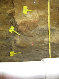
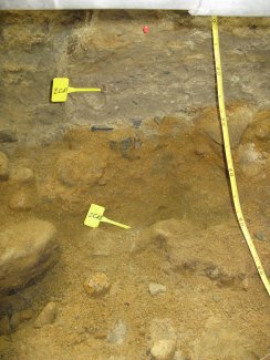
Megapit Images
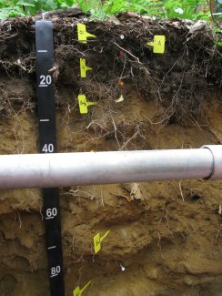
D01 HARV megapit soil profile 0-90 cm
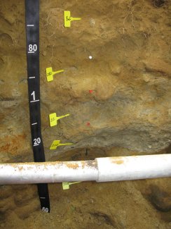
D01 HARV megapit soil profile 60-160 cm
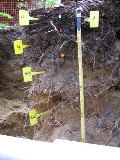
D01 HARV megapit soil profile 0-51 cm
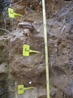
D01 HARV megapit soil profile 46-88 cm
D01 HARV megapit soil profile 79-122 cm
D01 HARV megapit soil profile 110-160 cm
Megapit Pedon Description
| Print Date | Apr 8 2015 |
|---|---|
| Description Date | Jul 17 2012 |
| Describer | Glenn Stanisewsky, Jacob Isleib, Marissa Theve |
| Site ID | S2012MA027001 |
| Pedon ID | S2012MA027001 |
| Lab Pedon # | 12N8063 |
| Soil Name as Described/Sampled | Henniker, taxadjunct |
| Soil Name as Correlated | Henniker, taxadjunct |
| Classification | Coarse-loamy over sandy or sandy-skeletal, mixed, semiactive, frigid Oxyaquic Dystrudepts |
| Pedon Type | taxadjunct to the series |
| Pedon Purpose | full pedon description |
| Taxon Kind | taxadjunct |
| State | Massachusetts |
| County | Worcester |
| MLRA | 144B -- New England and Eastern New York Upland, Northern Part |
| Soil Survey Area | MA614 -- Worcester County, Massachusetts, Northwestern Part 12-STJ -- Saint Johnsbury, Vermont |
| Map Unit | 908C -- Becket-Skerry association, 3 to 15 percent slopes, extremely stony |
| Std Latitude | 42.5356111 |
| Std Longitude | -72.1755556 |
| Latitude | 42 degrees 32 minutes 8.20 seconds north |
| Longitude | 72 degrees 10 minutes 32.00 seconds west |
| Datum | WGS84 |
| Physiographic Division | Appalachian Highlands |
| Physiographic Province | New England Province |
| Physiographic Section | New England upland section |
| Geomorphic Setting | on backslope of side slope of drumlin on upland |
| Upslope Shape | concave |
| Cross Slope Shape | linear |
| Particle Size Control Section | 29 to 104 cm. |
| Description origin | PedonPC |
| Diagnostic Features | ochric epipedon 0 to 17 cm. cambic horizon 17 to 82 cm. strongly contrasting particle size class 82 to cm. redox concentrations 96 to 113 cm. densic contact 113 to cm. densic materials 113 to 160 cm. |
| Primary Earth Cover | Tree cover |
| Secondary Earth Cover | Hardwoods |
| Existing Vegetation | lowbush blueberry, northern red oak, red maple, striped maple |
| Parent Material | lodgment till |
| Description database | KSSL |
| Cont. Site ID | S2012MA027001 |
| Top Depth (cm) | 113 |
| Bottom Depth (cm) | 160 |
| Restriction Kind | densic material |
| Restriction Hardness | noncemented |
| Slope (%) | 5.0 |
| Aspect (deg) | 82 |
| Drainage Class | well |
| Elevation (meters) | 365.8 |
| Horizon Details |
Oi--0 to 4 centimeters (0.0 to 1.6 inches); very dark brown (7.5YR 2.5/2) slightly decomposed plant material; many very fine roots throughout and many medium roots throughout and many fine roots throughout; strongly acid, pH 5.2, Bromcresol green; abrupt smooth boundary. Lab sample # 12N03205 A--4 to 9 centimeters (1.6 to 3.5 inches); very dark brown (10YR 2/2) highly organic fine sandy loam; weak fine granular, and weak medium granular structure; very friable; many very fine roots throughout and many medium roots throughout and many fine roots throughout and many coarse roots throughout; 5 percent nonflat subangular 2 to 75-millimeter unspecified fragments and 5 percent nonflat subangular 75 to 250-millimeter unspecified fragments; strongly acid, pH 5.4, Bromcresol green; clear wavy boundary. Lab sample # 12N03206 Ap--9 to 17 centimeters (3.5 to 6.7 inches); dark brown (10YR 3/3) gravelly fine sandy loam; weak fine subangular blocky, and weak medium subangular blocky structure; very friable; many very fine roots throughout and many medium roots throughout and many fine roots throughout and many coarse roots throughout; 5 percent nonflat subangular 75 to 250-millimeter unspecified fragments and 12 percent nonflat subangular 2 to 75-millimeter unspecified fragments; strongly acid, pH 5.4, Bromcresol green; clear wavy boundary. Lab sample # 12N03207 B/E--17 to 32 centimeters (6.7 to 12.6 inches); 90 percent brownish yellow (10YR 6/8) and 10 percent yellowish brown (10YR 5/6) fine sandy loam; weak fine subangular blocky, and weak medium subangular blocky structure; friable; many medium roots throughout and common fine roots throughout and few coarse roots throughout; few medium tubular and few fine dendritic tubular and few fine tubular pores; 5 percent nonflat subangular 75 to 250-millimeter unspecified fragments and 7 percent nonflat subangular 2 to 75-millimeter unspecified fragments; strongly acid, pH 5.4, Bromcresol green; gradual wavy boundary. Lab sample # 12N03208 Bw1--32 to 53 centimeters (12.6 to 20.9 inches); yellowish brown (10YR 5/6) fine sandy loam; weak coarse subangular blocky structure; friable; common medium roots throughout and common fine roots throughout and few coarse roots throughout; few medium tubular and few fine dendritic tubular and few fine tubular and few coarse tubular pores; 5 percent nonflat subangular 2 to 75-millimeter unspecified fragments and 7 percent nonflat subangular 75 to 250-millimeter unspecified fragments; strongly acid, pH 5.3, Bromcresol green; gradual wavy boundary. Lab sample # 12N03209 Bw2--53 to 82 centimeters (20.9 to 32.3 inches); dark yellowish brown (10YR 4/6) fine sandy loam; weak coarse subangular blocky structure; friable; few medium roots throughout and few fine roots throughout and few coarse roots throughout; few fine dendritic tubular and few fine tubular pores; 5 percent nonflat subangular 2 to 75-millimeter unspecified fragments and 7 percent nonflat subangular 75 to 250-millimeter unspecified fragments; strongly acid, pH 5.3, Bromcresol green; clear smooth boundary. Lab sample # 12N03210 2BC--82 to 96 centimeters (32.3 to 37.8 inches); dark yellowish brown (10YR 4/4) loamy sand; single grain; loose; few very fine roots throughout and few fine roots throughout; 5 percent nonflat subangular 75 to 250-millimeter unspecified fragments and 5 percent nonflat subangular 2 to 75-millimeter unspecified fragments; strongly acid, pH 5.3, Bromcresol green; clear smooth boundary. Lab sample # 12N03211 2C--96 to 113 centimeters (37.8 to 44.5 inches); 75 percent light olive brown (2.5Y 5/3) and 25 percent yellowish brown (10YR 5/6) sand; single grain; loose; very few medium roots throughout and very few fine roots throughout; 5 percent coarse prominent 5YR 4/6), moist, masses of oxidized iron; 12 percent nonflat subangular 2 to 75-millimeter unspecified fragments; moderately acid, pH 5.7, Chlorophenol red; abrupt smooth boundary. Lab sample # 12N03212 2Cd1--113 to 133 centimeters (44.5 to 52.4 inches); olive brown (2.5Y 4/3) gravelly coarse sandy loam; massive; firm; 3 percent nonflat subangular 75 to 250-millimeter unspecified fragments and 25 percent nonflat subangular 2 to 75-millimeter unspecified fragments; moderately acid, pH 5.7, Chlorophenol red; abrupt wavy boundary. Lab sample # 12N03213 2Cd2--133 to 160 centimeters (52.4 to 63.0 inches); 60 percent strong brown (7.5YR 4/6) and 40 percent brown (10YR 4/3) very gravelly coarse sand; massive; firm; 5 percent nonflat subangular 250 to 600-millimeter unspecified fragments and 10 percent nonflat subangular 75 to 250-millimeter unspecified fragments and 40 percent nonflat subangular 2 to 75-millimeter unspecified fragments; moderately acid, pH 5.7, Chlorophenol red. Lab sample # 12N03214. |
Credits: This megapit soil pedon description was generously created by USDA Natural Resource Conservation Service staff, with particular thanks to Larry West, Jon Hempel, and numerous field staff.