Great Smoky Mountains National Park NEON (GRSM) Soil Descriptions
Distributed Soils Reports
Pedon Descriptions
Pit‐level observations and field measurements reported using the standard NRCS format. They contain volume estimates for coarse fragments > 20 mm where applicable.
Site Level Plot Summary
A narrative summary that places the sampled soil pedons in the broader context of soils and geomorphology for the entire NEON site.
Megapit Images
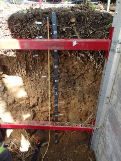
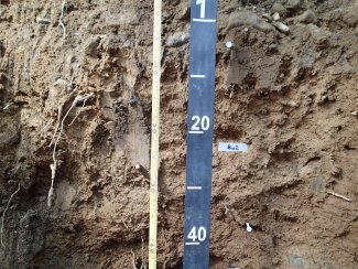
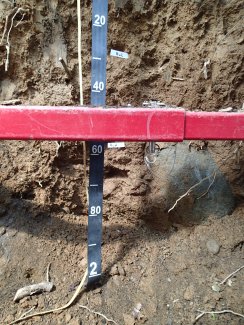
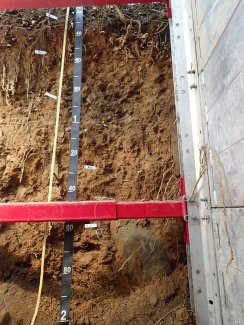
D07 GRSM megapit soil profile 0-200 cm
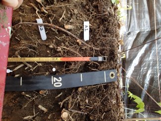
D07 GRSM megapit soil profile 0-34 cm
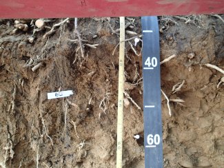
D07 GRSM megapit soil profile 28-64 cm
D07 GRSM megapit soil profile 55-103 cm
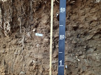
D07 GRSM megapit soil profile 99-143 cm
D07 GRSM megapit soil profile 115-200 cm
D07 GRSM megapit soil profile 25-200 cm
Megapit Pedon Description
| Print Date | Feb 18 2016 |
|---|---|
| Description Date | Apr 21 2015 |
| Describer | Anthony Khiel, Mark Hudson, Tiffany Smith |
| Site ID | S2015TN155400 |
| Pedon ID | S2015TN155001 |
| Pedon Note | Pedon sample area: No "O" horizons were described due to the lack of decomposed leaf litter. Last seasons' leafs are present, but no Oa,e, or i material is present at the sample location. ; Nutrient recycling in the upper layers. Roots are concentrated in the Surface horizons (A1 & A2) and all root size categories are described as many; roots decrease quickly with depth. Roots are in the surface layers due to higher organic matter, more than adequate rainfall (>50"/year), and low nutrients in the subsoil (Thunderhead Sandstone). |
| Lab Source ID | KSSL |
| Lab Pedon # | 15N0538 |
| Soil Name as Described/Sampled | Spivey |
| Classification | Loamy-skeletal, isotic, mesic Typic Humudepts |
| Pedon Type | correlates to named soil |
| Pedon Purpose | laboratory sampling site |
| Taxon Kind | series |
| Associated Soils | Cheoah, Junaluska, Rubble Areas, Soco |
| Physiographic Division | Appalachian Highlands |
| Physiographic Province | Blue Ridge Province |
| Physiographic Section | Southern section |
| Local Physiographic Area | Blue Ridge; Qa--Surfical Deposits |
| Geomorphic Setting | on toeslope of base slope of mountainbase of 1 cove on toeslope of base slope of mountainbase of 2 mountains |
| Upslope Shape | linear |
| Cross Slope Shape | concave |
| Particle Size Control Section | 25 to 100 cm. |
| Description origin | NASIS |
| State | Tennessee |
| County | Sevier |
| MLRA | 130B -- Southern Blue Ridge |
| Soil Survey Area | TN155 -- Sevier County, Tennessee SS0130 -- Blue Ridge MLRA Soil Survey 6-WAY -- Waynesville, North Carolina |
| Map Unit | SsC -- Spivey-Santeetlah-Nowhere complex, 8 to 15 percent slopes, very stony |
| Quad Name | Gatlinburg, Tennessee |
| Std Latitude | 35.6883889 |
| Std Longitude | -83.5018333 |
| Latitude | 35 degrees 41 minutes 18.20 seconds north |
| Longitude | 83 degrees 30 minutes 6.60 seconds west |
| Datum | WGS84 |
| UTM Zone | 17 |
| UTM Easting | 273608 meters |
| UTM Northing | 3952271 meters |
| Primary Earth Cover | Tree cover |
| Secondary Earth Cover | Hardwoods |
| Parent Material | skeletal loamy colluvium derived from metasedimentary rock |
| Bedrock Kind | metasedimentary rock |
| Bedrock Hardness | very strongly cemented |
| Surface Fragments | 2.0 percent nonflat subrounded indurated 250- to 600-millimeter metasedimentary rock fragments and 0.5 percent nonflat subrounded indurated 600- to 2000-millimeter metasedimentary rock fragments |
| Description database | KSSL |
| Diagnostic Features | umbric epipedon 0 to 32 cm. cambic horizon 32 to 58 cm. |
| Slope (%) | 8.0 |
| Elevation (meters) | 599.0 |
| Aspect (deg) | 350 |
| MAAT (C) | 12.1 |
| MSAT (C) | 21.2 |
| MWAT (C) | 2.6 |
| MAP (mm) | 1,483 |
| Frost-Free Days | 128 |
| Drainage Class | well |
| Horizon Details |
A1--0 to 21 centimeters (0.0 to 8.3 inches); very dark brown (10YR 2/2) exterior loam; moderate fine granular structure; very friable, nonsticky, nonplastic; low excavation difficulty; many very fine roots throughout and many very coarse roots throughout and many medium roots throughout and many fine roots throughout and many coarse roots throughout; very fine irregular and fine irregular pores; distinct organic stains on all faces of peds; 1 percent flat subrounded very strongly cemented 2 to 75-millimeter metasedimentary rock fragments and 2 percent nonflat subrounded very strongly cemented 2 to 75-millimeter metasedimentary rock fragments; gradual smooth boundary. Lab sample # 15N02858, 15N02864 A2--21 to 32 centimeters (8.3 to 12.6 inches); dark brown (10YR 3/3) exterior loam; moderate medium granular, and weak medium subangular blocky structure; very friable, nonsticky, slightly plastic; low excavation difficulty; many very fine roots throughout and many very coarse roots throughout and many medium roots throughout and many fine roots throughout and many coarse roots throughout; very fine irregular and fine irregular pores; distinct organic stains on all faces of peds; 1 percent flat subrounded very strongly cemented 2 to 75-millimeter metasedimentary rock fragments and 2 percent nonflat subrounded very strongly cemented 2 to 75-millimeter metasedimentary rock fragments; abrupt smooth boundary. Lab sample # 15N02859, 15N02865 Bw--32 to 58 centimeters (12.6 to 22.8 inches); yellowish brown (10YR 5/6) crushed sandy clay loam; weak medium subangular blocky structure; friable, slightly sticky, slightly plastic; low excavation difficulty; common medium roots top of horizon and common fine roots top of horizon; very fine irregular and fine irregular pores; 1 percent nonflat subrounded very strongly cemented 75 to 250-millimeter metasedimentary rock fragments and 2 percent flat subrounded very strongly cemented 2 to 75-millimeter metasedimentary rock fragments and 5 percent nonflat subrounded very strongly cemented 2 to 75-millimeter metasedimentary rock fragments; abrupt smooth boundary. Lab sample # 15N02860, 15N02866 C--58 to 100 centimeters (22.8 to 39.4 inches); dark yellowish brown (10YR 3/4) exterior extremely gravelly loamy sand; structureless medium single grain; loose, nonsticky, nonplastic; moderate excavation difficulty; 10 percent flat subrounded very strongly cemented 2 to 75-millimeter metasedimentary rock fragments and 12 percent nonflat subrounded very strongly cemented 75 to 250-millimeter metasedimentary rock fragments and 45 percent nonflat subrounded very strongly cemented 2 to 75-millimeter metasedimentary rock fragments; abrupt wavy boundary. Lab sample # 15N02861, 15N02867 Bw1--100 to 140 centimeters (39.4 to 55.1 inches); yellowish brown (10YR 5/6) crushed clay loam; weak medium subangular blocky structure; friable, nonsticky, slightly plastic; low excavation difficulty; few medium roots throughout; fine irregular pores; 1 percent nonflat subrounded very strongly cemented 2 to 75-millimeter metasedimentary rock fragments and 1 percent flat subrounded very strongly cemented 2 to 75-millimeter metasedimentary rock fragments; abrupt smooth boundary. Lab sample # 15N02862, 15N02868 Bw2--140 to 206 centimeters (55.1 to 81.1 inches); dark yellowish brown (10YR 4/6) crushed extremely bouldery clay loam; weak coarse subangular blocky structure; friable, nonsticky, slightly plastic; high excavation difficulty; few fine roots around fragments; fine irregular pores; 2 percent flat subrounded strongly cemented 2 to 75-millimeter metasedimentary rock fragments and 3 percent nonflat subrounded very strongly cemented 2 to 75-millimeter metasedimentary rock fragments and 4 percent nonflat subrounded very strongly cemented 75 to 250-millimeter metasedimentary rock fragments and 12 percent nonflat subrounded very strongly cemented 250 to 600-millimeter metasedimentary rock fragments and 55 percent nonflat subrounded very strongly cemented 600 to 2000-millimeter metasedimentary rock fragments. Lab sample # 15N02863, 15N02869. |
Credits: This megapit soil pedon description was generously created by USDA Natural Resource Conservation Service staff, with particular thanks to Larry West, Jon Hempel, and numerous field staff.